Landsat Enhanced Thematic Mapper Plus (ETM+) Collection 2 (C2) Level 2 (L2) Data Format Control Book (DFCB)阅读记录
自己是GIS专业的学生,对遥感并不是很熟悉。但是为了完成遥感的大创,要加倍努力呀,前几天读了Landsat4-7、8-9C2L2SP的Guide,今天开始学习一下Data Format Control Book(DFCB)
ETM+
Executive Summary
1.C2L2产品由LPGS生成、以GeoTIFF格式存储
2.DPAS CCB对DFCB文档负责
Document History
……
Current Version 5.0 - September2020
一些专有名词解释
ETM+ ST Band Specifications(规格、技术指标)
Section1 Introduce
The Landsat mission is a joint mission formulated, implemented, and operated by the National Aeronautics and Space Administration (NASA) and the Department of the Interior (DOI) U.S. Geological Survey (USGS). Landsat is a remote-sensing satellite mission providing coverage of the Earth’s land surfaces. The Landsat series of satellites continue the 40+ years of global data collection and distribution
陆地卫星任务由NASA和DOI制定、实施和操作……
1.1 Background(背景)
The goal of Landsat is to continue the collection, archival(归档), and distribution of multispectral imagery affording global, synoptic(同步的), and repetitive coverage of the Earth’s land surfaces at a scale where natural and human-induced(人为的) changes can be detected, differentiated, characterized, and monitored over time. The Landsat programmatic goals are stated in the United States Code, Title 15 Chapter 82 “Land Remote Sensing Policy” (derived from the Land Remote Sensing Policy Act of 1992). This policy requires that the Landsat Project provide data into the future that are sufficiently consistent with previous Landsat data to allow the detection and quantitative characterization of changes in or on the surface of the Earth. The highly successful Landsat series of missions have provided satellite coverage of the Earth’s continental surfaces since 1972. The data from these missions constitute the longest continuous record of Earth’s surface as seen from space.
1.2 Purpose and Scope(目标和范围)
This Data Format Control Book (DFCB) provides a high-level description of the Enhanced Thematic Mapper Plus (ETM+) L2 product distribution.
This document describes the formats and data contents of the C2 L2 output files. The output format generated by the LPGS for distribution is COG.
1.3 Document Organization(文档组织)
This document contains the following sections:
• Section 1 provides an introduction
• Section 2 provides an overview of C2 L2 product files
• Section 3 provides data format definitions of the L2 product files
• Appendix A provides a list of acronyms
• The References section provides a list of reference documents
1.4 Terminology(术语)
Level 2 Science Product (L2SP) — The L2SP includes Surface Reflectance (SR), Surface Temperature (ST), ST intermediate bands, an angle coefficients file, and Quality Assessment (QA) Bands. It is created by correcting a Level 1 Geometric(几何) Systematic (L1GS), Level 1 Systematic Terrain(地形) (Corrected) (L1GT), or Level 1 Precision Terrain (Corrected) (L1TP) product for atmospheric(大气) effects.
Level 2 Surface Reflectance (L2SR) — The L2SR includes Surface Reflectance (SR), an angle coefficients file, and Quality Assessment (QA) Bands. It is created by correcting a Level 1 Systematic Terrain (Corrected) (L1GT) or Level 1 Precision Terrain (Corrected) (L1TP) product for atmospheric effects.
Section2 Overview of L2 Product Files
This section provides an overview(概述) of the L2 product files
2.1 Level 2 Output Files Overview
The standard L2SP is a Digital Number (DN) product stored in a 16-bit unsigned integer(16位无符号整形) format.(数值范围:0 ~
SR bands approximate(近似) what a field spectroradiometer(光谱辐射计) sensor held just above the Earth’s surface would measure.Goddard Space Flight Center (GSFC)’s Total Ozone Mapping Spectrometer(光谱仪) (TOMS) data and National Centers for Environmental Prediction (NCEP)’s surface pressure, water vapor, and air temperature are used by Landsat Ecosystem Disturbance Adaptive Processing System (LEDAPS).SR bands require Top of Atmosphere (TOA) reflectance bands corrected for per-pixel sun angles. SR bands are generated only for scenes with the Solar Zenith Angle (SZA, 太阳天顶角) less than 76°. The SZA is 90° minus the sun elevation angle. Most L2 products are from scenes between 65 degrees north and 65 degrees south latitude. Table 2-2 lists specifications for the SR bands.(南北纬65°之间)
The ST band provides the temperature of the Earth’s surface in Kelvin (K). The Advanced Spaceborne Thermal Emission and Reflection Radiometer Global Emissivity Dataset (ASTER GED) by Land Processes Distributed Active Archive Center (LPDAAC) is used in the ST algorithm for ETM+. Goddard Earth Observing System Model, Version 5 (GEOS-5) Forward Process for Instrument Teams (FP-IT) data are used in the Single Channel algorithm for atmospheric correction. If GEOS data are unavailable NASA’s Modern-Era Retrospective analysis for Research and Application, Version 2 (MERRA-2) data are used in its place. The algorithm that generates the ST band requires L1’s Band 6 Virtual Channel Identifier (VCID) 1 and VCID 2 as inputs. Band 6 VCID 1 contains the low-gain (6L) data, while Band 6 VCID 2 contains the high-gain (6H) data. Band 6 VCID 2 is the default input to generate the ST band. If Band 6 VCID 2 has saturation for a pixel, then data from Band 6 VCID 1 is used in generating the ST band for that pixel instead. Table 2-3 lists specifications for the ST band. The ST band is scaled to Kelvin by multiplying the DN times the value for TEMPERATURE_MULT_BAND_ST_B6 and adding the value for TEMPERATURE_ADD_BAND_ST_B6. All values can be found in Table 3-4.
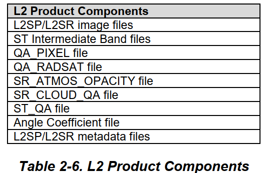
The L2SP image data are atmospherically corrected and available as COG files. Table 2-1 shows the band identification, while Table 2-6 lists the L2SP components. If ST cannot be produced, an SR-only product is attempted. Atmospheric auxiliary data used in processing a L1 product into the L2 product are described in LSDS-1329 Landsat Atmospheric Auxiliary Data Data Format Control Book (DFCB).
Seven ST intermediate bands are included in the L2SP when the Single Channel algorithm is used to generate ST. These ST intermediate bands consist of a thermal(热) band converted to radiance(辐射度), upwelled radiance(上涌辐射度), downwelled radiance(下涌辐射度), atmospheric- 4 - LSDS-1337 Version 5.0 transmittance(透射率), emissivity(发射率) estimated from ASTER GED, emissivity standard deviation, and pixel distance to cloud. Table 2-4 provides specifications for these bands.
Five QA Bands are included in the L2 product. These QA Bands consist of the L1 pixel, L1 radiometric saturation(饱和度), SR atmospheric opacity(不透明度), SR cloud, and ST. Table 2-5 lists specifications for these bands.


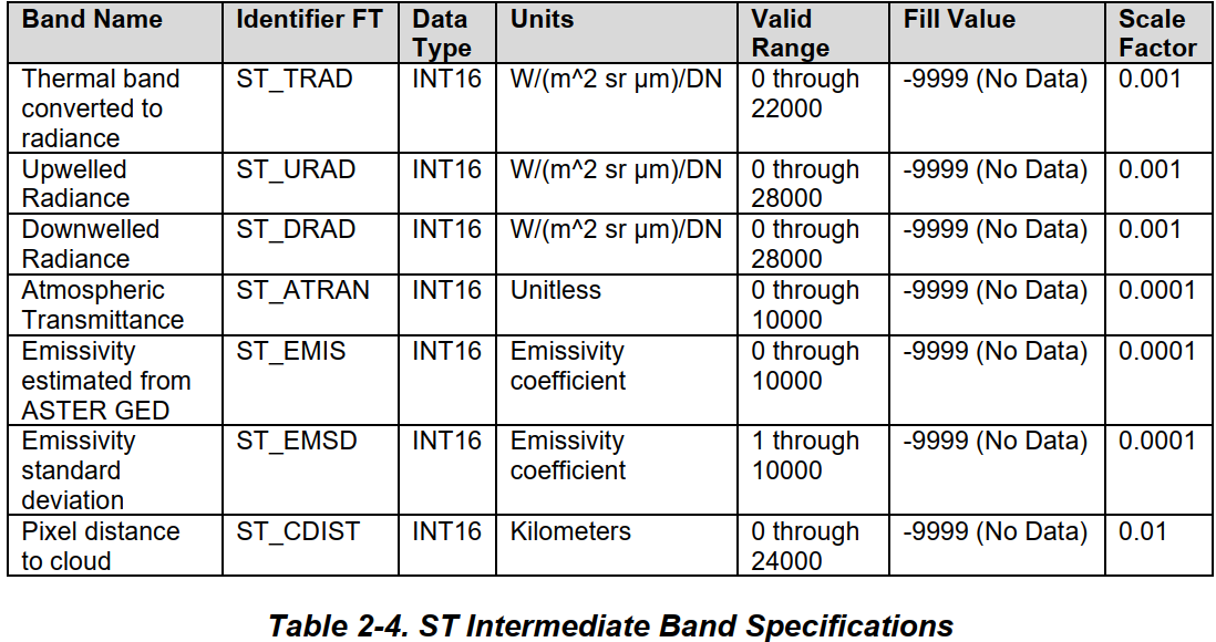
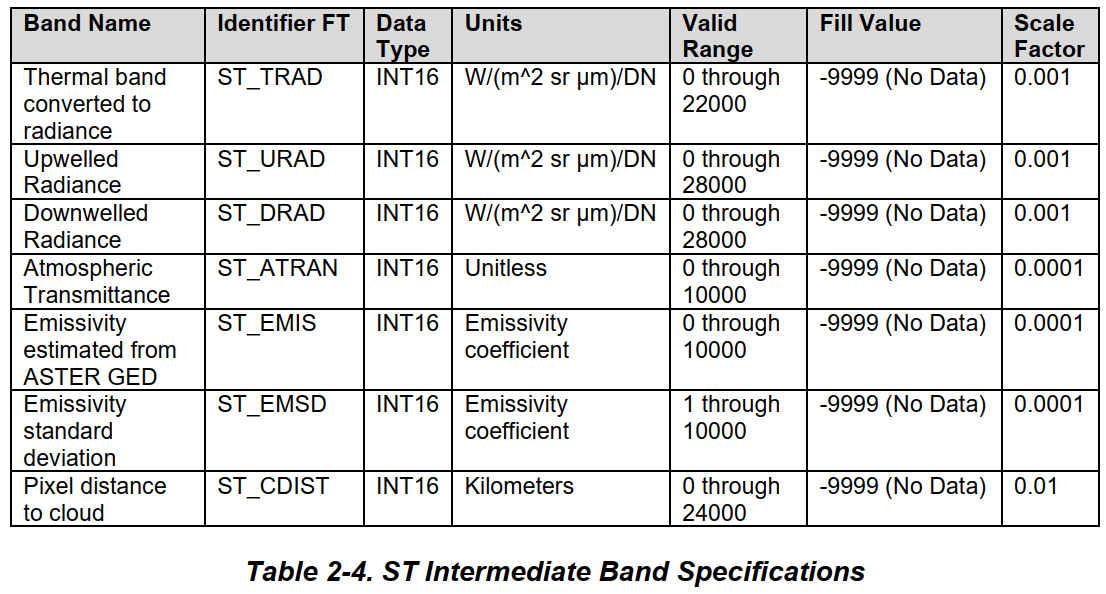
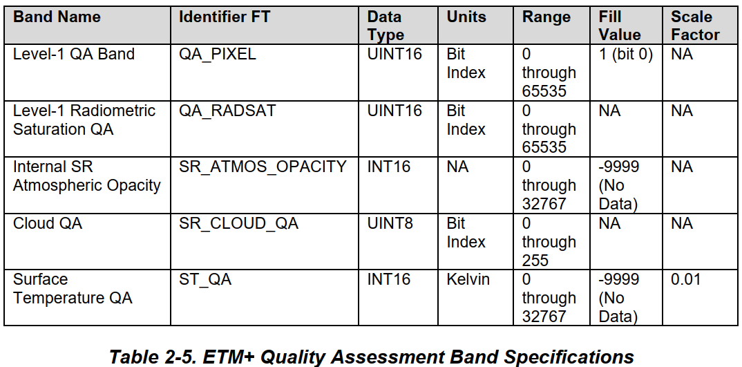
2.1.1 Product Files
The product consists of individual files that are listed in Table 2-6. The files are unbundled(无捆绑的) and can be downloaded individually.
2.1.2 Naming Convention(命名习惯)
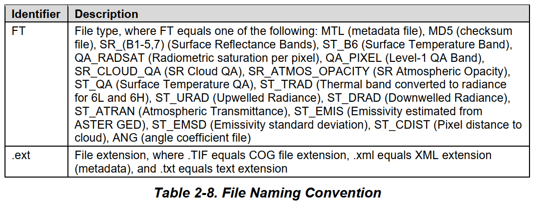
Table 2-7 describes the Landsat Product Identifier: LXSS_LLLL_PPPRRR_YYYYMMDD_yyyymmdd_CC_TX. Table 2-7 and Table 2-8 contain the file types and extensions for file names associated with the L2 products.
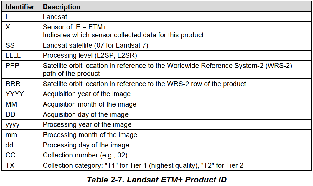
The Landsat Product ID described in Table 2-7 is the first part of the file name, the file type and extension components of the file name are described in Table 2-8.
The Landsat Product ID, file type, and extension make the file name: LXSS_LLLL_PPPRRR_YYYYMMDD_yyyymmdd_CC_TX_FT.ext
2.1.3 Example File Names
LE07_L2SP_222005_20140922_20140923_02_T1_SR_B1.TIF
LE07_L2SP_222005_20140922_20140923_02_T1_SR_B2.TIF
LE07_L2SP_222005_20140922_20140923_02_T1_SR_B3.TIF
LE07_L2SP_222005_20140922_20140923_02_T1_SR_B4.TIF
LE07_L2SP_222005_20140922_20140923_02_T1_SR_B5.TIF
LE07_L2SP_222005_20140922_20140923_02_T1_SR_B7.TIF
2.1.3.1 SR Image Files
LE07_L2SP_222005_20140922_20140923_02_T1_ST_B6.TIF
2.1.3.2 ST Image Files
LE07_L2SP_222005_20140922_20140923_02_T1_ST_B6.TIF
2.1.3.3 Radiometric Saturation
LE07_L2SP_222005_20140922_20140923_02_T1_QA_RADSAT.TIF
2.1.3.4 QA band
LE07_L2SP_222005_20140922_20140923_02_T1_QA_PIXEL.TIF
2.1.3.5 ST QA
LE07_L2SP_222005_20140922_20140923_02_T1_ST_QA.TIF
2.1.3.6 SR Atmosphere Opacity
LE07_L2SP_222005_20140922_20140923_02_T1_SR_ATMOS_OPACITY.TIF
2.1.3.7 SR Cloud QA
LE07_L2SP_222005_20140922_20140923_02_T1_SR_CLOUD_QA.TIF
2.1.3.8 Metadata(元数据)
LE07_L2SP_222005_20140922_20140923_02_T1_MTL.txt
LE07_L2SP_222005_20140922_20140923_02_T1_MTL.xml
2.1.3.9 Angle Coefficient File
LE07_L2SP_222005_20140922_20140923_02_T1_ANG.txt
2.1.3.10 ST Intermediate Band Files
LE07_L2SP_222005_20140922_20140923_02_T1_ST_TRAD.TIF
LE07_L2SP_222005_20140922_20140923_02_T1_ST_URAD.TIF
LE07_L2SP_222005_20140922_20140923_02_T1_ST_DRAD.TIF
LE07_L2SP_222005_20140922_20140923_02_T1_ST_ATRAN.TIF
LE07_L2SP_222005_20140922_20140923_02_T1_ST_EMIS.TIF
LE07_L2SP_222005_20140922_20140923_02_T1_ST_EMSD.TIF
LE07_L2SP_222005_20140922_20140923_02_T1_ST_CDIST.TIF
2.1.3.11 Checksum
LE07_L2SP_222005_20140922_20140923_02_T1_MD5.txt
Section3 Data Format Definition
This section describes the storage format for the data. Refer to LSDS-1414 Landsat 7 (L7) Enhanced Thematic Mapper Plus (ETM+) Collection 2 (C2) Level 1 (L1) Data Format Control Book (DFCB) for a more detailed description of the GeoTIFF format. Refer to LSDS-1414 for a more detailed description of TIFF. Refer to LSDS-1388 Landsat Cloud Optimized GeoTIFF (COG) Data Format Control Book (DFCB) for a more detailed description of COG. The Geospatial Data Abstraction Library (GDAL) NODATA tag is used to indicate, in conjunction with the value for the pixel, which pixel(s) have no data for applicable bands. If GDAL’s NODATA tag is included for the band, it is mentioned in this section.
3.1 L2 Image Files
3.1
3.3
3.4
3.5
3.6
3.7
3.8 L2 Metadata Files
The L2 metadata files are created during product generation and contain information specific to the product ordered. The L1 metadata is encapsulated in the L2 metadata. Some files listed in the L1 metadata are not contained in the L2 product; these files are highlighted in red in Table 3-4. Some of the fields listed in the L1 metadata do not apply to the files in the L2 product. These fields are for provenance and are highlighted in red in Table 3-4. Files and fields included for provenance also have an asterism symbol: ⁂ at the end of each row.
Table 3-4 lists the L2 metadata using Object Description Language (ODL). Table 3-5 shows the structure of the Extensible Markup Language (XML) metadata file. The XML file contains only parent elements and children elements. Table 3-5 does not show every possible value associated with each parameter name like Table 3-4 does.
The PRODUCT_CONTENTS group contains information about files in the product (e.g.,it includes file names and the data type for the GeoTIFF files). Most of the parameters and parameter values in PRODUCT_CONTENTS are duplicates of the same parameter and parameter values in LEVEL2_PROCESSING_RECORD.
Important fields from the L1 metadata apply to the L2 product. The number of lines in the file referenced by the FILE_NAME_QUALITY_L1_PIXEL are the same as the number of lines given by REFLECTIVE_LINES, found in the L1 metadata, in the metadata file.
3.9
3.10
3.10 Checksum File
A single checksum file is created for all the files in the product. The checksum file contains a Message-Digest Algorithm 5 (MD5) checksum for every file. The file is in plain text format and contains the output from md5sum for each file. The checksum file is not distributed with the final product.
太多了,先主要看Book吧,有时间再往博客上弄


【推荐】国内首个AI IDE,深度理解中文开发场景,立即下载体验Trae
【推荐】编程新体验,更懂你的AI,立即体验豆包MarsCode编程助手
【推荐】抖音旗下AI助手豆包,你的智能百科全书,全免费不限次数
【推荐】轻量又高性能的 SSH 工具 IShell:AI 加持,快人一步
· AI与.NET技术实操系列:向量存储与相似性搜索在 .NET 中的实现
· 基于Microsoft.Extensions.AI核心库实现RAG应用
· Linux系列:如何用heaptrack跟踪.NET程序的非托管内存泄露
· 开发者必知的日志记录最佳实践
· SQL Server 2025 AI相关能力初探
· winform 绘制太阳,地球,月球 运作规律
· 震惊!C++程序真的从main开始吗?99%的程序员都答错了
· AI与.NET技术实操系列(五):向量存储与相似性搜索在 .NET 中的实现
· 超详细:普通电脑也行Windows部署deepseek R1训练数据并当服务器共享给他人
· 【硬核科普】Trae如何「偷看」你的代码?零基础破解AI编程运行原理