Raster dataset statistics
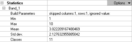
In Arcmap, The statistics for a raster dataset can be viewed on the Raster Dataset Properties dialog box. Below is an example showing the statistics for a thematic raster dataset such as a land-use dataset. Statistics are calculated for each band; if there is more than one band in the raster datasets, the statistics for each band are present. You can see that the parameters used to build the statistics are listed. The statistics that are calculated include the minimum and maximum pixel values as well as the mean and standard deviation of the calculated pixel values, and if the dataset is thematic, the number of classes is listed. If your dataset is continuous, there will be no classes.
Geoprocessing tool reference > Data Management toolbox > Raster toolset > Raster Properties toolset > Tools > Calculate Statistics