html5 image>usemap (attribute)
# html5 image>usemap (attribute)
https://caniuse.com/#search=usemap

http://www.w3.org/TR/html5/embedded-content-0.html#image-maps-0
4.7.1.1.12 Image maps
If an img element has a usemap attribute which references a map element containing area elements that have href attributes, the img is considered to be interactive content. In such cases, always provide a text alternative for the image using the alt attribute.
Consider the following image which is a map of Katoomba, it has 2 interactive regions corresponding to the areas of North and South Katoomba:
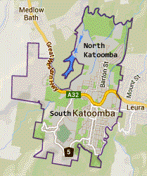
The text alternative is a brief description of the image. The alt attribute on each of the area elements provides text describing the content of the target page of each linked region:
<p>View houses for sale in North Katoomba or South Katoomba:</p>
 <p><img src="imagemap.png" width="209" alt="Map of Katoomba" height="249" usemap="#Map">

 <map name="Map">
 <area shape="poly" coords="78,124,124,10,189,29,173,93,168,132,136,151,110,130"
 href="north.html" alt="Houses in North Katoomba">
 <area shape="poly" coords="66,63,80,135,106,138,137,154,167,137,175,133,144,240,49,223,17,137,17,61"
 alt="Houses in South Katoomba" href="south.html">
 </map>

本文首发于博客园,作者:xgqfrms,原文链接:https://www.cnblogs.com/xgqfrms/p/4859608.html
未经授权禁止转载,违者必究!


【推荐】国内首个AI IDE,深度理解中文开发场景,立即下载体验Trae
【推荐】编程新体验,更懂你的AI,立即体验豆包MarsCode编程助手
【推荐】抖音旗下AI助手豆包,你的智能百科全书,全免费不限次数
【推荐】轻量又高性能的 SSH 工具 IShell:AI 加持,快人一步
· AI与.NET技术实操系列(二):开始使用ML.NET
· 记一次.NET内存居高不下排查解决与启示
· 探究高空视频全景AR技术的实现原理
· 理解Rust引用及其生命周期标识(上)
· 浏览器原生「磁吸」效果!Anchor Positioning 锚点定位神器解析
· DeepSeek 开源周回顾「GitHub 热点速览」
· 记一次.NET内存居高不下排查解决与启示
· 物流快递公司核心技术能力-地址解析分单基础技术分享
· .NET 10首个预览版发布:重大改进与新特性概览!
· .NET10 - 预览版1新功能体验(一)