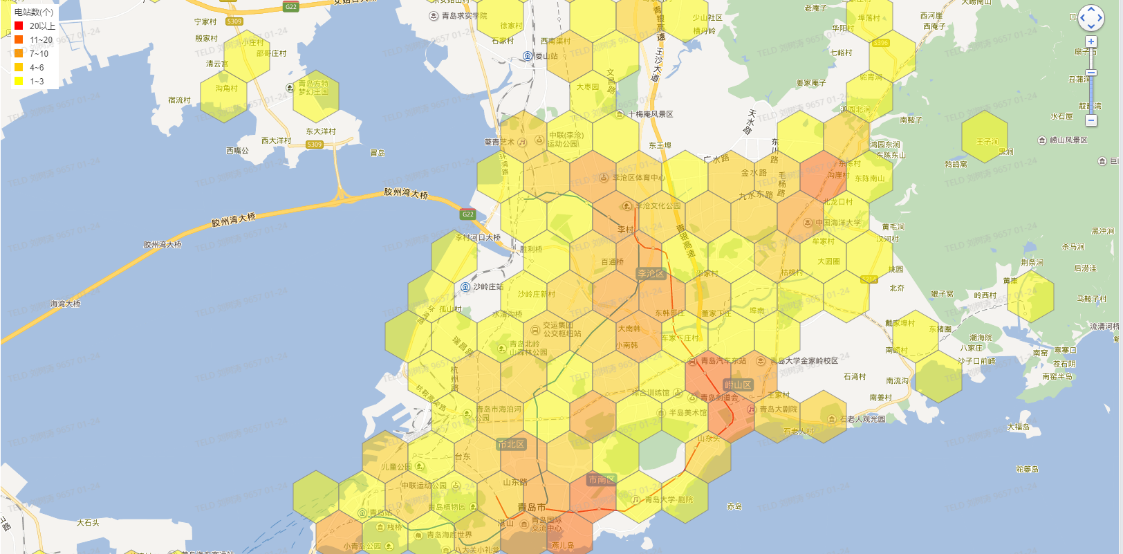
需求:计算不同区域范围,X公里半径内实体店或场站覆盖率。
实现思路:
- 为了便于理解,将地球看成一个基于经纬度线的坐标系。将经度和纬度看成二维坐标系中的两个纬度,横轴表示经度[-180o, 0o),(0o, 180o],纵轴表示纬度[-90o, 0o),(0o, 90o]。
- 以最小纬度和经度对应坐标为第一个六角形中心点,在经度方向循环计算六角形各顶点(顶点开始,顺时针,命名:Point1,Point2,Point3,Point4,Point5,Point6)及中心点(Point0)坐标,直至六角形中心点经度大于等于最大经度。 存储六角形标记为(0,0),(0,1),(0,2) ......., 表示六边形位于第0行第N列
- 第一行计算完成后,开始计算第2行,如下图,第2行(奇数行), 除第1个和最后一个点作特殊处理外,其它点的 Point3、Point4、Point5是重叠的,注意坐标的处理,否则会出现偏差

- 在维度方向上按上一步循环。完成整个区域范围内六角边分割,注意:为了快速定位,还需计算出每个六角形中心点对应的Geohash,根据半径不一致,可选择不同的Geohash级别
- 根据场站经纬度计算出30级 Cell ID 值 及 Geohash 码
- 根据 Geohash 码找出附近的六角形,通过六顶点坐标 构造 IRegion, 判断场站是否包含在六边形内,如果不包含,再次计算出当前Geohash码周边8个Geohash框,再次计算
- 至此完成此区域内场站命中的六角形。
关键代码
- 根据中心点坐标、边长、偏差角度(中心点至顶点开始)计算下一个点坐标
-
public const double Ea = 6378137; // 赤道半径(米) public const double Eb = 6356725; // 极半径 (米) /// <summary> /// /// </summary> /// <param name="lat"></param> /// <param name="lng"></param> /// <param name="distance"></param> /// <param name="angle"></param> /// <returns></returns> public static Point GetPoint(double lat, double lng, double distance, double angle) { double dx = distance * 1000 * Math.Sin(angle * Math.PI / 180.0); double dy = distance * 1000 * Math.Cos(angle * Math.PI / 180.0); double ec = Eb + (Ea - Eb) * (90.0 - lat) / 90.0; double ed = ec * Math.Cos(lat * Math.PI / 180.0); double newLon = (dx / ed + lng * Math.PI / 180.0) * 180.0 / Math.PI; double newLat = (dy / ec + lat * Math.PI / 180.0) * 180.0 / Math.PI; return new Point(newLat, newLon); } - 计算场站所属六边形
-
 View Code
/// <summary>
        ///
        /// </summary>
        /// <param name="destRows"></param>
        /// <param name="cell"></param>
        /// <param name="level"></param>
        /// <param name="staid"></param>
        /// <param name="hashMap"></param>
        /// <param name="geohashValue"></param>
        /// <returns></returns>
        private string GetPgID(DataTable dest, S2Cell cell,string geohashValue)
        {
            //先找当前geohash4的值
            string pgID = this.GetPGIDByHash(dest, cell, geohashValue);
            if (string.IsNullOrEmpty(pgID) == false)
                return pgID;


            //当前hash未命中时,找相邻8格
            List<string> hashLst = GeoHashService.Default.GetGeoHashExpand(geohashValue);
            foreach (string ghValue in hashLst)
            {
                pgID = this.GetPGIDByHash(dest, cell, ghValue);
                if (string.IsNullOrEmpty(pgID) == false)
                    return pgID;
            }

            return string.Empty;
        }

       /// <summary>
       ///
       /// </summary>
       /// <param name="dest"></param>
       /// <param name="cell"></param>
       /// <param name="geohashValue"></param>
       /// <returns></returns>
        private string GetPGIDByHash(DataTable dest, S2Cell cell, string geohashValue)
        {
            DataRow[] destRows = dest.Select(string.Format("{0} = '{1}'", M_GEOHASH, geohashValue));  //城市均分的网格

            foreach (DataRow dRow in destRows)
            {
                string pgID = Convert.ToString(dRow["ID"]);
                IS2Region cells = this.BuildPolygon(dRow);

                if (cells.Contains(cell) == true)
                {
                    return pgID;
                }
            }

            return string.Empty;
        }

        /// <summary>
        /// 构造容器
        /// </summary>
        /// <param name="row"></param>
        /// <returns></returns>
        private IS2Region BuildPolygon(DataRow row)
        {
            List<S2Point> lst = new List<S2Point>();
            lst.Add(this.GetPoint(Convert.ToDouble(row["lat1"]), Convert.ToDouble(row["lng1"])));
            lst.Add(this.GetPoint(Convert.ToDouble(row["lat2"]), Convert.ToDouble(row["lng2"])));
            lst.Add(this.GetPoint(Convert.ToDouble(row["lat3"]), Convert.ToDouble(row["lng3"])));
            lst.Add(this.GetPoint(Convert.ToDouble(row["lat4"]), Convert.ToDouble(row["lng4"])));
            lst.Add(this.GetPoint(Convert.ToDouble(row["lat5"]), Convert.ToDouble(row["lng5"])));
            lst.Add(this.GetPoint(Convert.ToDouble(row["lat6"]), Convert.ToDouble(row["lng6"])));

            S2Loop loop = new S2Loop(lst);
            loop.Normalize();
            return loop;
        }
示例效果
参考资料


