About Radio Telemetry
Drone Telemetry Data
Drone telemetry is data gathered about the aircraft and its surroundings that is sent back to the operator or ground control station (GCS). This information may be taken from the drone’s autopilot, sensors such as accelerometers, gyroscopes and GPS, or from subsystems such as the aircraft’s power source.
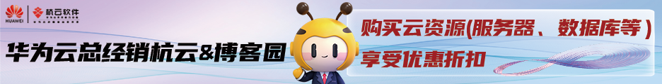
TMV Telemetry Transmitter by Meteksan
Telemetry data provides the ability to track UAV status in real time, allowing pilots to monitor position, attitude and altitude to ensure smooth and efficient flight. Depending on the sensors installed on board, it may also provide information on components and subsystems such as the RPM of the rotors and the voltage level of the batteries.
Drone telemetry data is transmitted via radio, often on a separate link to the drone control signals to provide increased safety. This requires the drone to have an onboard radio transmitter as well as a receiver, and appropriate antennas. Common drone radio telemetry frequencies include 433 MHz, 915 Mhz and the newer 2.4 GHz. Wireless telemetry data can also be transmitted via Wi-Fi and LTE networks such as 4G and 5G, which typically have a shorter range than other radio technologies but provides higher data rates.
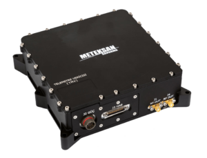
VU Telemetry Viewer by SkyHopper
FPV Telemetry
Another form of telemetry is FPV (first-person view), in which a video feed from an onboard camera is transmitted back to the drone pilot and displayed on a monitor or a pair of FPV goggles. This allows the pilot to see exactly what the drone “sees”, and in good communication environments, can provide a unique form of real-time situational awareness.
Marine & Subsea Telemetry
关于无线电遥测
无人机遥测数据
无人机遥测是收集有关飞机及其周围环境的数据,并将其发送回操作员或地面控制站(GCS)。这些信息可能来自无人机的自动驾驶仪,传感器,如加速度计,陀螺仪和GPS,或子系统,如飞机的电源。
跟踪遥测
TMV遥测发射机
TMV遥测发射器由Meteksan
遥测数据提供了实时跟踪无人机状态的能力,允许飞行员监控位置、姿态和高度,以确保平稳高效的飞行。根据安装在板上的传感器,它还可以提供关于组件和子系统的信息,如转子的RPM和电池的电压水平。
无人机遥测数据通过无线电传输,通常通过单独的连接到无人机控制信号,以提高安全性。这要求无人机有机载无线电发射器和接收器,以及适当的天线。常见的无人机无线电遥测频率包括433 MHz, 915 MHz和更新的2.4 GHz。无线遥测数据也可以通过Wi-Fi和LTE网络(如4G和5G)传输,这些网络通常比其他无线电技术的距离更短,但提供更高的数据速率。
SkyHopper-VU-Telemetry-viewer
SkyHopper的VU遥测查看器
废票遥测
另一种形式的遥测是FPV(第一人称视角),其中机载摄像头的视频反馈被传输回无人机飞行员,并显示在监视器或一副FPV护目镜上。这使得飞行员能够准确地看到无人机“看到”的东西,并且在良好的通信环境中,可以提供一种独特的实时态势感知形式。
海洋和海底遥测
遥测传输也可用于海洋和水下系统,如rov(远程操作车辆)和auv(自主水下航行器),由于无线电波无法在水下传播,通常通过声学方法传输。
本文来自博客园,作者:slowlydance2me,转载请注明原文链接:https://www.cnblogs.com/slowlydance2me/p/17159245.html