
Geometric aspects of mapping reference surfaces
Introduction
The surface of the Earth is anything but uniform. The oceans, can be treated as reasonably uniform, but the surface or topography of the land masses exhibits large vertical variations between mountains and valleys. These variations make it impossible to approximate the shape of the Earth with any reasonably simple mathematical model. Consequently, two main reference surfaces have been established to approximate the shape of the Earth. One reference surface is called the Geoid, the other reference surface is the ellipsoid. These are illustrated in the figure below.
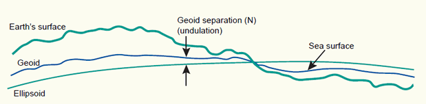
The Earth's surface, and two reference surfaces used to approximate it: the Geoid, and a reference ellipsoid. The deviation between the Geoid and a reference ellipsoid is called geoid separation (N).
1 The Geoid and the vertical datum
We can simplify matters by imagining that the entire Earth’s surface is covered by water. If we ignore tidal and current effects on this ‘global ocean’, the resultant water surface is affected only by gravity. This has an effect on the shape of this surface because the direction of gravity - more commonly known as plumb line - is dependent on the mass distribution inside the Earth. Due to irregularities or mass anomalies in this distribution the 'global ocean' results in an undulated surface. This surface is called the Geoid. The plumb line through any surface point is always perpendicular to it.
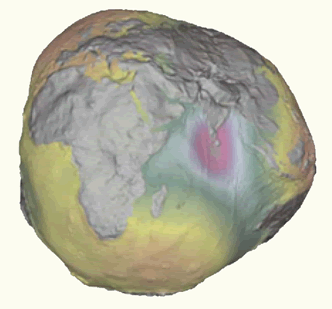
The Geoid, exaggerated to illustrate the complexity of its surface.
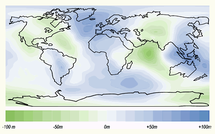
Where a mass deficiency exists, the Geoid will dip below the mean ellipsoid. Conversely, where a mass surplus exists, the Geoid will rise above the mean ellipsoid. These influences cause the Geoid to deviate from a mean ellipsoidal shape by up to +/- 100 meters. The deviation between the Geoid and an ellipsoid is called the geoid separation (N) or geoid undulation. The biggest presently known undulations are the minimum in the Indian Ocean with N = -100 meters and the maximum in the northern part of the Atlantic Ocean with N = +70 meters (figure below).

 浙公网安备 33010602011771号