

uniapp 引入腾讯地图并且进行定位
首先:https://lbs.qq.com/miniProgram/plugin/pluginGuide/routePlan 这是腾讯地图地址

安装一波( 这是为了防止出现腾讯地图跨域问题 )
npm i --save vue-jsonp
在 main.js 文件
1 2 3 | // 引入腾讯地图import {VueJsonp} from 'vue-jsonp'Vue.use(VueJsonp) |
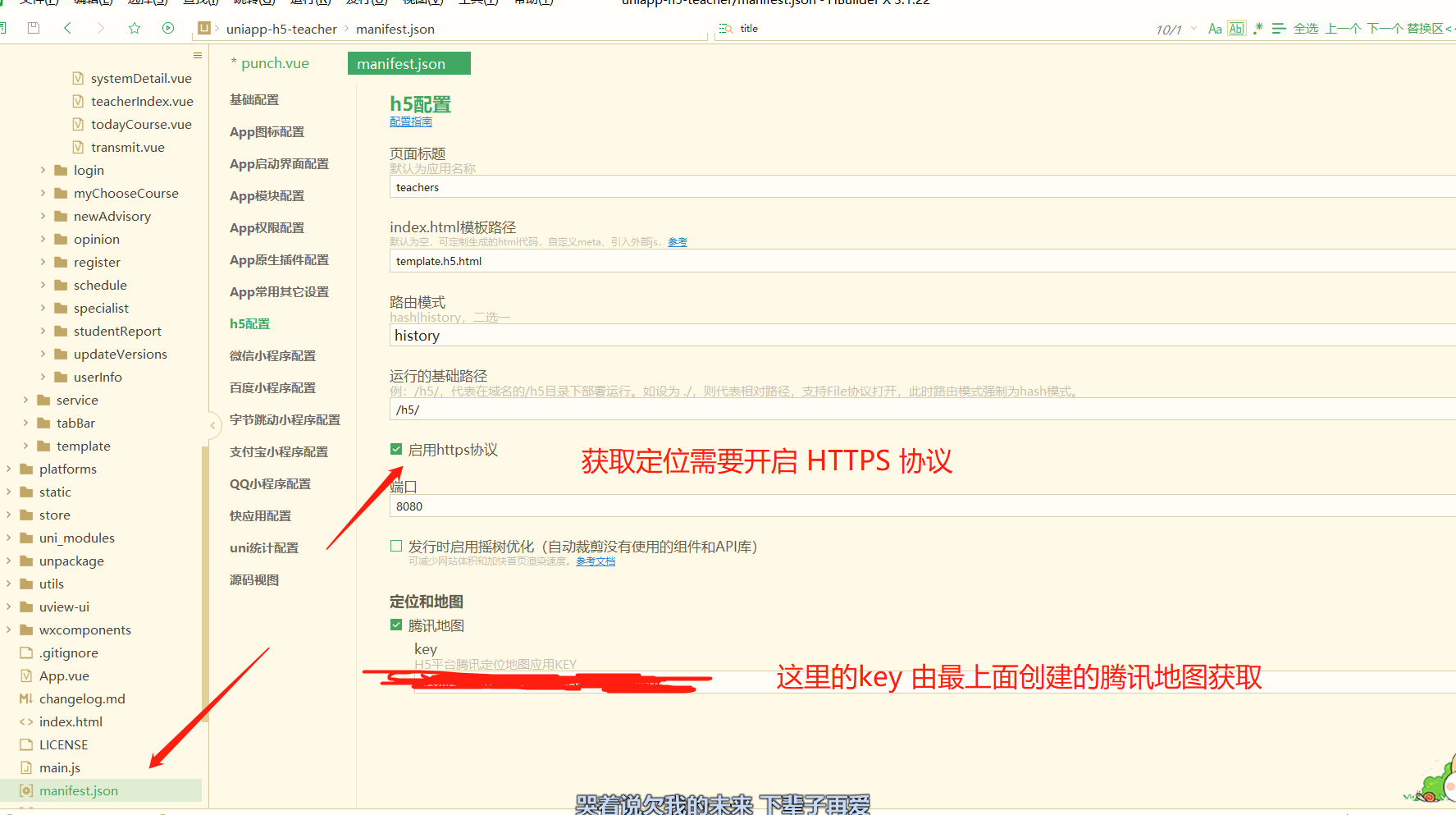
manifest.json 文件开始配置
复制进去就行

搜索:usingComponents

"plugins": {
            "routePlan": {
            "version": "1.0.12",
            "provider": " 小程序的APPID "
            }
        },
        "permission": {
            "scope.userLocation": {
                "desc": "位置信息效果展示"
            }
        }
配置上自己的小程序appid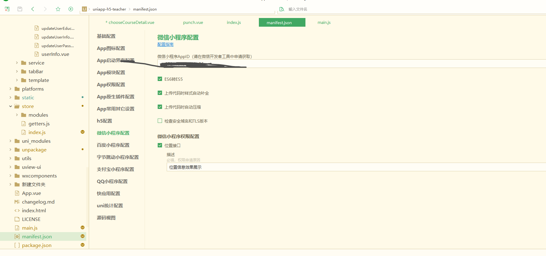
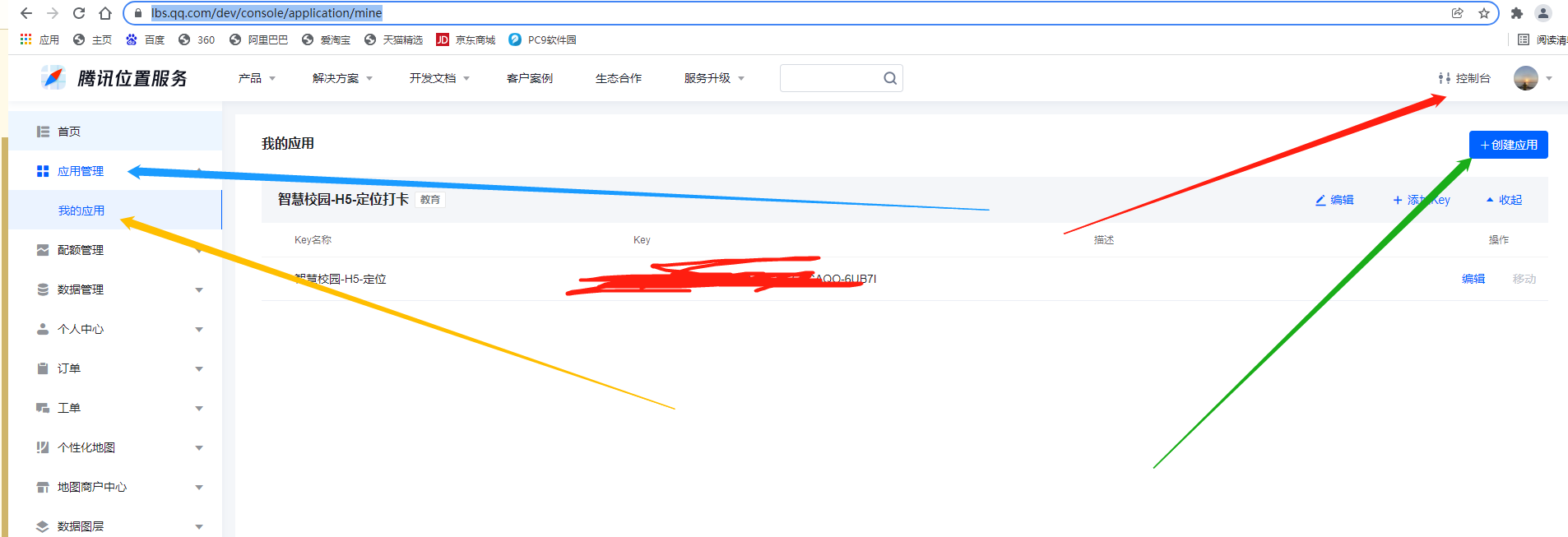
配置上去腾讯地图创建的key
最后,在应用的文件
1 2 3 4 5 | <!-- :polyline="polyline" --> //点 连城线,需要的可以自己配置 <map style="width: 100%; height: 300px;" :circles="circles" :scale="scale" :latitude="latitude" :longitude="longitude" :markers="covers"> <!-- <cover-view class="cover-view" @click="onControltap"></cover-view> --> </map> |
data定义 显示默认定位
1 2 3 4 5 6 7 8 9 10 11 12 13 14 15 16 17 18 19 20 21 22 23 24 25 26 27 28 29 30 31 32 33 34 35 36 37 38 39 40 41 42 43 44 45 46 47 48 49 50 51 52 53 54 55 56 57 58 59 60 61 62 63 64 65 66 67 68 69 70 71 72 73 74 75 76 77 78 79 80 81 82 83 84 85 86 87 88 89 90 91 92 | // title: 'map', latitude: 22.571164, // 默认的经纬度 longitude: 113.926937, covers: [{ // 开始的经纬度 latitude: 22.573164, //纬度 longitude: 113.926937, //经度 // #ifdef APP-PLUS iconPath: '../../../static/image/location@3x.png', //显示的图标 // #endif // #ifndef APP-PLUS iconPath: '../../../static/location.png', //显示的图标 // #endif // title: '阿打算', //标注点名 label: { //为标记点旁边增加标签 // content: '文本1', //文本 color: '#F76350', //文本颜色 // anchorX: 0, //label的坐标,原点是 marker 对应的经纬度 // anchorY: -80, //label的坐标,原点是 marker 对应的经纬度 bgColor: '#fff', //背景色 padding: 5, //文本边缘留白 borderWidth: 1, //边框宽度 borderColor: '#D84C29', //边框颜色 textAlign: 'right' //文本对齐方式。 }, callout: { content: '当前所在', color: '#F76350', fontSize: 12 } }, { // 圆圈所在的点 =》 终点 latitude: 22.57147, longitude: 113.92663, // #ifdef APP-PLUS iconPath: '../../../static/image/location@3x.png', //显示的图标 // #endif // #ifndef APP-PLUS iconPath: '../../../static/location.png', //显示的图标 // #endif // iconPath: '../../static/image/personal_center.png', // title: '阿迪达斯', // x: 39.9, // y: 116.399, label: { // content: '打卡范围', color: '#F76350', bgColor: '#fff', padding: 5, borderRadius: 4 }, callout: { content: '打卡范围', color: '#F76350', fontSize: 12 } } ], scale: 15, //地图层级 // controls: [{ // //在地图上显示控件,控件不随着地图移动 // id: 1, //控件id // // iconPath: '../../static/image/equipment_deployment_two.png', //显示的图标 // position: { // //控件在地图的位置 // left: 15, // top: 15, // width: 50, // height: 50 // } // }], //在地图上显示圆 circles: [{ latitude: 22.57147, longitude: 113.92663, fillColor: '#AACCEE32', //填充颜色 color: '#AACCEE', //描边的颜色 radius: 100, //半径 strokeWidth: 2 //描边的宽度 }], // polyline: [{ //根据点画线 // //指定一系列坐标点,从数组第一项连线至最后一项 => 第一个输入开始点, 第二个输入结束点 // // points: [{ latitude: 22.57147, longitude: 113.92663 }, { latitude: 22.57091694019413, longitude: 113.9270532131195 }], // points: [], // color: '#0000AA', //线的颜色 // width: 2, //线的宽度 // dottedLine: true, //是否虚线 // arrowLine: true //带箭头的线 开发者工具暂不支持该属性 // }] |
methods 方法 /=
1 2 3 4 5 6 7 8 9 10 11 12 13 14 15 16 17 18 19 20 21 22 23 24 25 26 27 28 29 30 31 32 33 34 35 36 37 38 39 40 41 42 43 44 45 46 47 48 49 50 51 52 53 54 55 56 57 58 59 60 61 62 63 64 65 66 | //坐标转腾讯地图坐标 bMapTransQQMap(lng, lat) { let locationObj = lat + ',' + lng; let url = 'https://apis.map.qq.com/ws/coord/v1/translate'; var that = this this.$jsonp(url, { key: 'KKSBZ-53WRP-GBSD7-LE373-SGAQO-6UB7I', locations: locationObj, type: 1, output: 'jsonp' }).then(res => { that.latitude = res.locations[0].lat that.longitude = res.locations[0].lng that.covers[0].latitude = res.locations[0].lat that.covers[0].longitude = res.locations[0].lng //判断是否在规定打卡距离以内 that.GetDistance(that.covers[0].latitude, that.covers[0].longitude, that.covers[1].latitude, that.covers[1].longitude) }) }, //获取当前位置 =》 由于腾讯地图获取定位会飘,因此采用原生获取定位的方法。目前项目应用中属于最准确的一个,没有之一。 getAddress() { if (navigator.geolocation) { var that = this var timer = navigator.geolocation.watchPosition( function(ev) { //step3:用经纬度描述具体位置 // alert(parseFloat(ev.coords.longitude)); // alert(parseFloat(ev.coords.latitude)); that.bMapTransQQMap(parseFloat(ev.coords.longitude), parseFloat(ev.coords.latitude)) }, function(err) { alert('定位超时,请稍后再试!') // alert(err.code) // alert(err.message) //清除多次地理位置定位 navigator.geolocation.clearWatch(timer); }, { /*数据收集 : json的形式 enableHighAcuracy : 更精确的查找,默认false timeout :指定获取地理位置的超时时间,默认不限时,单位为毫秒 maximumAge :最长有效期,在重复获取地理位置时,此参数指定多久再次获取位置。 */ enableHighAccuracy: true, maximumAge: 2000 }) } else { alert('您的浏览器不支持geolocation定位!,请更换浏览器'); } }, // 方法定义 lat,lng 计算距离 GetDistance(lat1, lng1, lat2, lng2) { var radLat1 = lat1 * Math.PI / 180.0; var radLat2 = lat2 * Math.PI / 180.0; var a = radLat1 - radLat2; var b = lng1 * Math.PI / 180.0 - lng2 * Math.PI / 180.0; var s = 2 * Math.asin(Math.sqrt(Math.pow(Math.sin(a / 2), 2) + Math.cos(radLat1) * Math.cos(radLat2) * Math.pow(Math.sin(b / 2), 2))); s = s * 6378137.0; // EARTH_RADIUS; s = Math.round(s * 10000) / 10000; this.dakajuli = parseFloat(s) }, |
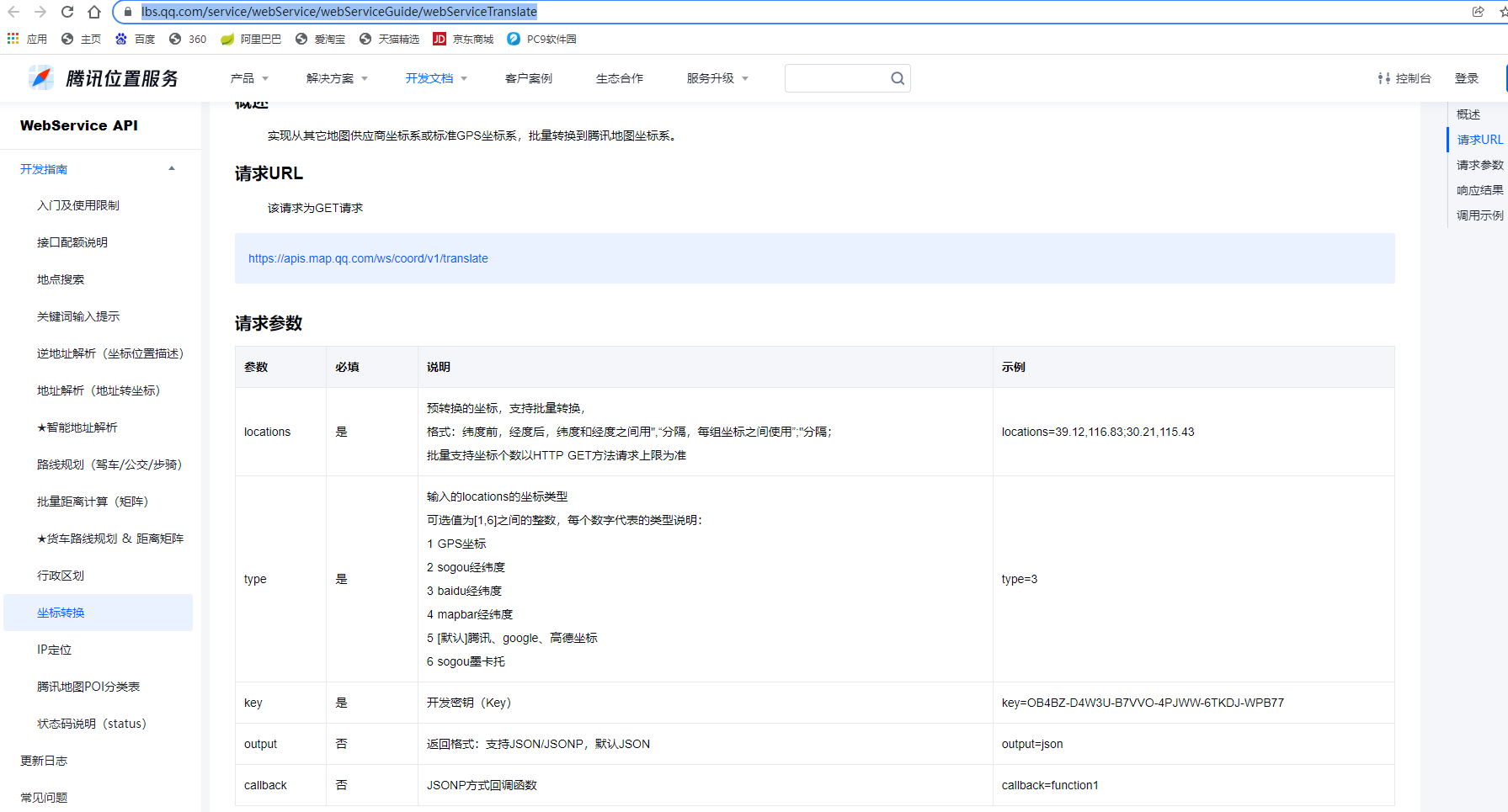
腾讯地图坐标转换API: https://lbs.qq.com/service/webService/webServiceGuide/webServiceTranslate


【推荐】国内首个AI IDE,深度理解中文开发场景,立即下载体验Trae
【推荐】编程新体验,更懂你的AI,立即体验豆包MarsCode编程助手
【推荐】抖音旗下AI助手豆包,你的智能百科全书,全免费不限次数
【推荐】轻量又高性能的 SSH 工具 IShell:AI 加持,快人一步
· 基于Microsoft.Extensions.AI核心库实现RAG应用
· Linux系列:如何用heaptrack跟踪.NET程序的非托管内存泄露
· 开发者必知的日志记录最佳实践
· SQL Server 2025 AI相关能力初探
· Linux系列:如何用 C#调用 C方法造成内存泄露
· 无需6万激活码!GitHub神秘组织3小时极速复刻Manus,手把手教你使用OpenManus搭建本
· Manus爆火,是硬核还是营销?
· 终于写完轮子一部分:tcp代理 了,记录一下
· 别再用vector<bool>了!Google高级工程师:这可能是STL最大的设计失误
· 单元测试从入门到精通