SpringBoot 使用 Redis Geo
本文转载自:https://www.imooc.com/article/280622?block_id=tuijian_wz
https://www.cnblogs.com/simibaba/p/7090350.html
Redis 官方对 Geo 的描述
Redis 3.2 contains significant changes to the API and implementation of Redis. A new set of commands for Geo indexing was added (GEOADD, GEORADIUS and related commands).
关于 Geo,需要知道
- Redis 的 Geo 是在 3.2 版本才有的
- 使用 geohash 保存地理位置的坐标
- 使用有序集合(zset)保存地理位置的集合
6个操作命令
- GEOADD:增加某个地理位置的坐标
- GEOPOS:获取某个地理位置的坐标
- GEODIST:获取两个地理位置的距离
- GEORADIUS:根据给定地理位置坐标获取指定范围内的地理位置集合
- GEORADIUSBYMEMBER:根据给定地理位置获取指定范围内的地理位置集合
- GEOHASH:获取某个地理位置的 geohash 值
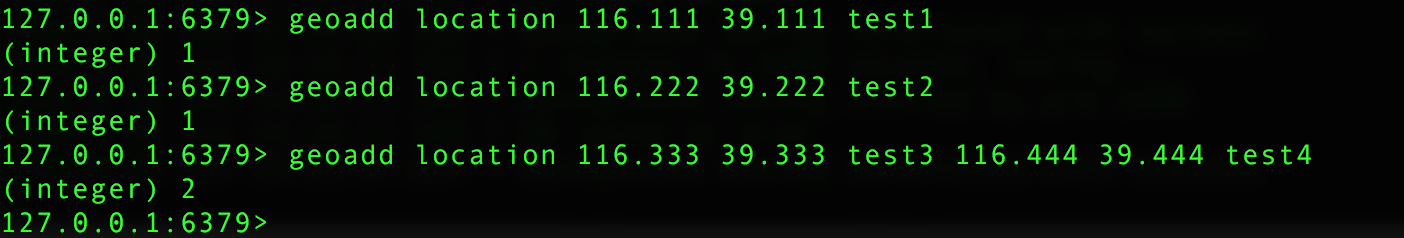
命令:GEOADD key longitude latitude member [longitude latitude member ...]
命令描述:将指定的地理空间位置(纬度、经度、名称)添加到指定的key中。
返回值:添加到sorted set元素的数目,但不包括已更新score的元素。
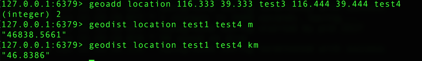
命令:GEODIST key member1 member2 [unit]
命令描述:
返回两个给定位置之间的距离。如果两个位置之间的其中一个不存在, 那么命令返回空值。指定单位的参数 unit 必须是以下单位的其中一个:
- m 表示单位为米。
- km 表示单位为千米。
- mi 表示单位为英里。
- ft 表示单位为英尺。
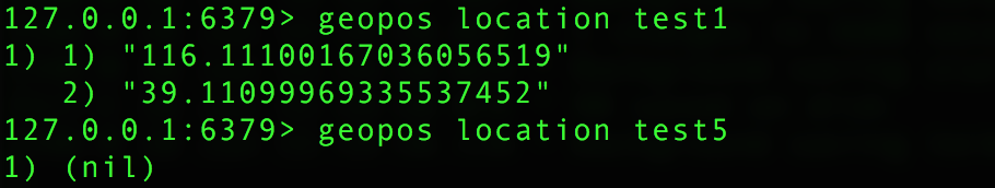
命令:GEOPOS key member [member ...]
命令描述:从key里返回所有给定位置元素的位置(经度和纬度)。
返回值:GEOPOS 命令返回一个数组, 数组中的每个项都由两个元素组成: 第一个元素为给定位置元素的经度, 而第二个元素则为给定位置元素的纬度。当给定的位置元素不存在时, 对应的数组项为空值。
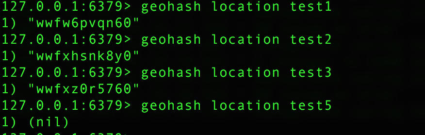
命令:GEOHASH key member [member ...]
命令描述:返回一个或多个位置元素的 Geohash 表示。通常使用表示位置的元素使用不同的技术,使用Geohash位置52点整数编码。由于编码和解码过程中所使用的初始最小和最大坐标不同,编码的编码也不同于标准。此命令返回一个标准的Geohash
返回值:一个数组, 数组的每个项都是一个 geohash 。 命令返回的 geohash 的位置与用户给定的位置元素的位置一一对应。
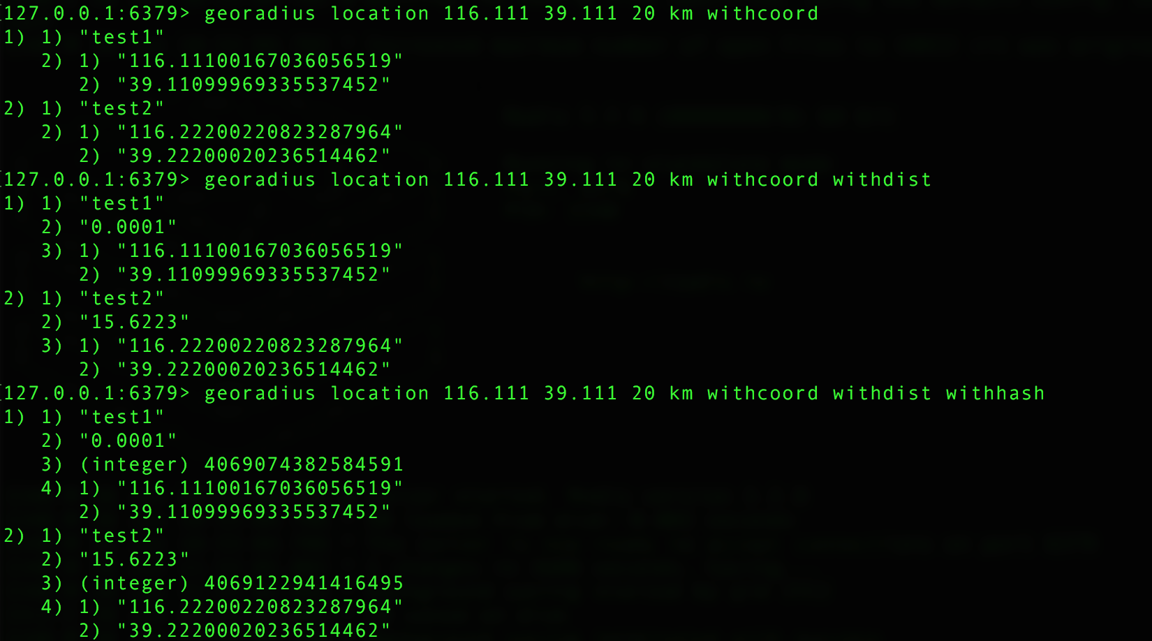
命令:GEORADIUS key longitude latitude radius m|km|ft|mi [WITHCOORD] [WITHDIST] [WITHHASH] [COUNT count]
命令描述:
以给定的经纬度为中心, 返回键包含的位置元素当中, 与中心的距离不超过给定最大距离的所有位置元素。
范围可以使用以下其中一个单位:
- m 表示单位为米。
- km 表示单位为千米。
- mi 表示单位为英里。
- ft 表示单位为英尺。
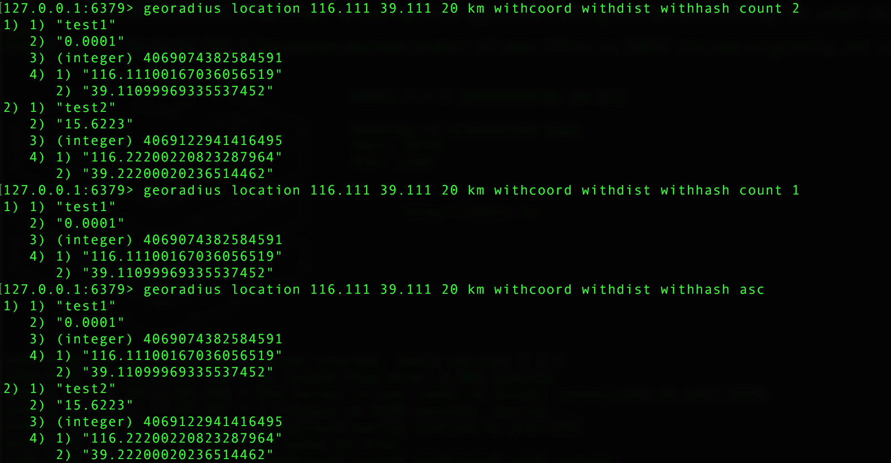
在给定以下可选项时, 命令会返回额外的信息:
WITHDIST: 在返回位置元素的同时, 将位置元素与中心之间的距离也一并返回。 距离的单位和用户给定的范围单位保持一致。WITHCOORD: 将位置元素的经度和维度也一并返回。WITHHASH: 以 52 位有符号整数的形式, 返回位置元素经过原始 geohash 编码的有序集合分值。 这个选项主要用于底层应用或者调试, 实际中的作用并不大。
命令默认返回未排序的位置元素。 通过以下两个参数, 用户可以指定被返回位置元素的排序方式:
ASC: 根据中心的位置, 按照从近到远的方式返回位置元素。DESC: 根据中心的位置, 按照从远到近的方式返回位置元素。
在默认情况下, GEORADIUS 命令会返回所有匹配的位置元素。 虽然用户可以使用 COUNT <count> 选项去获取前 N 个匹配元素, 但是因为命令在内部可能会需要对所有被匹配的元素进行处理, 所以在对一个非常大的区域进行搜索时, 即使只使用 COUNT 选项去获取少量元素, 命令的执行速度也可能会非常慢。 但是从另一方面来说, 使用 COUNT 选项去减少需要返回的元素数量, 对于减少带宽来说仍然是非常有用的。
返回值:
- 在没有给定任何
WITH选项的情况下, 命令只会返回一个像 [“New York”,”Milan”,”Paris”] 这样的线性(linear)列表。 - 在指定了
WITHCOORD、WITHDIST、WITHHASH等选项的情况下, 命令返回一个二层嵌套数组, 内层的每个子数组就表示一个元素。
在返回嵌套数组时, 子数组的第一个元素总是位置元素的名字。 至于额外的信息, 则会作为子数组的后续元素, 按照以下顺序被返回:
- 以浮点数格式返回的中心与位置元素之间的距离, 单位与用户指定范围时的单位一致。
- geohash 整数。
- 由两个元素组成的坐标,分别为经度和纬度。
命令:GEORADIUSBYMEMBER key member radius m|km|ft|mi [WITHCOORD] [WITHDIST] [WITHHASH] [COUNT count]
命令描述:这个命令和 GEORADIUS 命令一样, 都可以找出位于指定范围内的元素, 但是 GEORADIUSBYMEMBER 的中心点是由给定的位置元素决定的。
以下是java代码使用:
- vo 对象定义
import lombok.AllArgsConstructor;
import lombok.Builder;
import lombok.Data;
import lombok.NoArgsConstructor;

/**
 * <h1>城市信息</h1>
 * Created by Qinyi.
 */
@Data
@Builder
@NoArgsConstructor
@AllArgsConstructor
public class CityInfo {

    /** 城市 */
    private String city;

    /** 经度 */
    private Double longitude;

    /** 纬度 */
    private Double latitude;
}
- 服务接口定义
import com.imooc.ad.vo.CityInfo;
import org.springframework.data.geo.Circle;
import org.springframework.data.geo.Distance;
import org.springframework.data.geo.GeoResults;
import org.springframework.data.geo.Metric;
import org.springframework.data.geo.Point;
import org.springframework.data.redis.connection.RedisGeoCommands;

import java.util.Collection;
import java.util.List;

/**
 * <h1>Geo 服务接口定义</h1>
 * Created by Qinyi.
 */
public interface IGeoService {

    /**
     * <h2>把城市信息保存到 Redis 中</h2>
     * @param cityInfos {@link CityInfo}
     * @return 成功保存的个数
     * */
    Long saveCityInfoToRedis(Collection<CityInfo> cityInfos);

    /**
     * <h2>获取给定城市的坐标</h2>
     * @param cities 给定城市 key
     * @return {@link Point}s
     * */
    List<Point> getCityPos(String[] cities);

    /**
     * <h2>获取两个城市之间的距离</h2>
     * @param city1 第一个城市
     * @param city2 第二个城市
     * @param metric {@link Metric} 单位信息, 可以是 null
     * @return {@link Distance}
     * */
    Distance getTwoCityDistance(String city1, String city2, Metric metric);

    /**
     * <h2>根据给定地理位置坐标获取指定范围内的地理位置集合</h2>
     * @param within {@link Circle} 中心点和距离
     * @param args {@link RedisGeoCommands.GeoRadiusCommandArgs} 限制返回的个数和排序方式, 可以是 null
     * @return {@link RedisGeoCommands.GeoLocation}
     * */
    GeoResults<RedisGeoCommands.GeoLocation<String>> getPointRadius(
            Circle within, RedisGeoCommands.GeoRadiusCommandArgs args);

    /**
     * <h2>根据给定地理位置获取指定范围内的地理位置集合</h2>
     * */
    GeoResults<RedisGeoCommands.GeoLocation<String>> getMemberRadius(
            String member, Distance distance, RedisGeoCommands.GeoRadiusCommandArgs args);

    /**
     * <h2>获取某个地理位置的 geohash 值</h2>
     * @param cities 给定城市 key
     * @return city geohashs
     * */
    List<String> getCityGeoHash(String[] cities);
}
- 服务接口实现
import com.alibaba.fastjson.JSON;
import com.imooc.ad.service.IGeoService;
import com.imooc.ad.vo.CityInfo;
import lombok.extern.slf4j.Slf4j;
import org.springframework.beans.factory.annotation.Autowired;
import org.springframework.data.geo.Circle;
import org.springframework.data.geo.Distance;
import org.springframework.data.geo.GeoResults;
import org.springframework.data.geo.Metric;
import org.springframework.data.geo.Point;
import org.springframework.data.redis.connection.RedisGeoCommands;
import org.springframework.data.redis.core.GeoOperations;
import org.springframework.data.redis.core.StringRedisTemplate;
import org.springframework.stereotype.Service;

import java.util.Collection;
import java.util.HashSet;
import java.util.List;
import java.util.Set;

/**
 * <h1>Geo 服务接口实现</h1>
 * Created by Qinyi.
 */
@Slf4j
@Service
public class GeoServiceImpl implements IGeoService {

    private final String GEO_KEY = "ah-cities";

    /** redis 客户端 */
    private final StringRedisTemplate redisTemplate;

    @Autowired
    public GeoServiceImpl(StringRedisTemplate redisTemplate) {
        this.redisTemplate = redisTemplate;
    }

    @Override
    public Long saveCityInfoToRedis(Collection<CityInfo> cityInfos) {

        log.info("start to save city info: {}.", JSON.toJSONString(cityInfos));

        GeoOperations<String, String> ops = redisTemplate.opsForGeo();

        Set<RedisGeoCommands.GeoLocation<String>> locations = new HashSet<>();
        cityInfos.forEach(ci -> locations.add(new RedisGeoCommands.GeoLocation<String>(
                ci.getCity(), new Point(ci.getLongitude(), ci.getLatitude())
        )));

        log.info("done to save city info.");

        return ops.add(GEO_KEY, locations);
    }

    @Override
    public List<Point> getCityPos(String[] cities) {

        GeoOperations<String, String> ops = redisTemplate.opsForGeo();

        return ops.position(GEO_KEY, cities);
    }

    @Override
    public Distance getTwoCityDistance(String city1, String city2, Metric metric) {

        GeoOperations<String, String> ops = redisTemplate.opsForGeo();

        return metric == null ?
            ops.distance(GEO_KEY, city1, city2) : ops.distance(GEO_KEY, city1, city2, metric);
    }

    @Override
    public GeoResults<RedisGeoCommands.GeoLocation<String>> getPointRadius(
            Circle within, RedisGeoCommands.GeoRadiusCommandArgs args
    ) {

        GeoOperations<String, String> ops = redisTemplate.opsForGeo();

        return args == null ?
                ops.radius(GEO_KEY, within) : ops.radius(GEO_KEY, within, args);
    }

    @Override
    public GeoResults<RedisGeoCommands.GeoLocation<String>> getMemberRadius(
            String member, Distance distance, RedisGeoCommands.GeoRadiusCommandArgs args
    ) {

        GeoOperations<String, String> ops = redisTemplate.opsForGeo();

        return args == null ?
                ops.radius(GEO_KEY, member, distance) : ops.radius(GEO_KEY, member, distance, args);
    }

    @Override
    public List<String> getCityGeoHash(String[] cities) {

        GeoOperations<String, String> ops = redisTemplate.opsForGeo();

        return ops.hash(GEO_KEY, cities);
    }
}
- 测试用例
import com.alibaba.fastjson.JSON;
import com.imooc.ad.Application;
import com.imooc.ad.vo.CityInfo;
import org.junit.Before;
import org.junit.Test;
import org.junit.runner.RunWith;
import org.springframework.beans.factory.annotation.Autowired;
import org.springframework.boot.test.context.SpringBootTest;
import org.springframework.data.geo.Circle;
import org.springframework.data.geo.Distance;
import org.springframework.data.geo.Metrics;
import org.springframework.data.geo.Point;
import org.springframework.data.redis.connection.RedisGeoCommands;
import org.springframework.test.context.junit4.SpringRunner;

import java.util.ArrayList;
import java.util.Arrays;
import java.util.List;

/**
 * <h1>GeoService 测试用例</h1>
 * Created by Qinyi.
 */
@RunWith(SpringRunner.class)
@SpringBootTest(classes = {Application.class}, webEnvironment = SpringBootTest.WebEnvironment.NONE)
public class GeoServiceTest {

    /** fake some cityInfos */
    private List<CityInfo> cityInfos;

    @Autowired
    private IGeoService geoService;

    @Before
    public void init() {

        cityInfos = new ArrayList<>();

        cityInfos.add(new CityInfo("hefei", 117.17, 31.52));
        cityInfos.add(new CityInfo("anqing", 117.02, 30.31));
        cityInfos.add(new CityInfo("huaibei", 116.47, 33.57));
        cityInfos.add(new CityInfo("suzhou", 116.58, 33.38));
        cityInfos.add(new CityInfo("fuyang", 115.48, 32.54));
        cityInfos.add(new CityInfo("bengbu", 117.21, 32.56));
        cityInfos.add(new CityInfo("huangshan", 118.18, 29.43));
    }

    /**
     * <h2>测试 saveCityInfoToRedis 方法</h2>
     * */
    @Test
    public void testSaveCityInfoToRedis() {

        System.out.println(geoService.saveCityInfoToRedis(cityInfos));
    }

    /**
     * <h2>测试 getCityPos 方法</h2>
     * 如果传递的 city 在 Redis 中没有记录, 会返回什么呢 ? 例如, 这里传递的 xxx
     * */
    @Test
    public void testGetCityPos() {

        System.out.println(JSON.toJSONString(geoService.getCityPos(
                Arrays.asList("anqing", "suzhou", "xxx").toArray(new String[3])
        )));
    }

    /**
     * <h2>测试 getTwoCityDistance 方法</h2>
     * */
    @Test
    public void testGetTwoCityDistance() {

        System.out.println(geoService.getTwoCityDistance("anqing", "suzhou", null).getValue());
        System.out.println(geoService.getTwoCityDistance("anqing", "suzhou", Metrics.KILOMETERS).getValue());
    }

    /**
     * <h2>测试 getPointRadius 方法</h2>
     * */
    @Test
    public void testGetPointRadius() {

        Point center = new Point(cityInfos.get(0).getLongitude(), cityInfos.get(0).getLatitude());
        Distance radius = new Distance(200, Metrics.KILOMETERS);
        Circle within = new Circle(center, radius);

        System.out.println(JSON.toJSONString(geoService.getPointRadius(within, null)));

        // order by 距离 limit 2, 同时返回距离中心点的距离
        RedisGeoCommands.GeoRadiusCommandArgs args =
                RedisGeoCommands.GeoRadiusCommandArgs.newGeoRadiusArgs().includeDistance().limit(2).sortAscending();
        System.out.println(JSON.toJSONString(geoService.getPointRadius(within, args)));
    }

    /**
     * <h2>测试 getMemberRadius 方法</h2>
     * */
    @Test
    public void testGetMemberRadius() {

        Distance radius = new Distance(200, Metrics.KILOMETERS);

        System.out.println(JSON.toJSONString(geoService.getMemberRadius("suzhou", radius, null)));

        // order by 距离 limit 2, 同时返回距离中心点的距离
        RedisGeoCommands.GeoRadiusCommandArgs args =
                RedisGeoCommands.GeoRadiusCommandArgs.newGeoRadiusArgs().includeDistance().limit(2).sortAscending();
        System.out.println(JSON.toJSONString(geoService.getMemberRadius("suzhou", radius, args)));
    }

    /**
     * <h2>测试 getCityGeoHash 方法</h2>
     * */
    @Test
    public void testGetCityGeoHash() {

        System.out.println(JSON.toJSONString(geoService.getCityGeoHash(
                Arrays.asList("anqing", "suzhou", "xxx").toArray(new String[3])
        )));
    }
}

 浙公网安备 33010602011771号