学习在 ArcEngine 中使用 Geoprocessing
过去我们可以在ArcToolbox中新建Model,或是写python脚本、AML来构建新的模型,现在ArcEngine 9.2单独提供了com.esri.arcgis.geoprocessing.tools工具包,使得在二次开发中通过Geoprocessing构建应用模型,将ArcGIS众多分析工具集成到我们的应用中成为现实。
我们就在ArcEngine 9.2 for Java环境中看看如何使用Geoprocessing。
 import com.esri.arcgis.geoprocessing.GeoProcessor;import com.esri.arcgis.geoprocessing.tools.analysistools.Clip;// Initialize the GeoProcessor GeoProcessor gp = new GeoProcessor();Clip clip= new Clip("c:/data/mjrroads.shp", "c:/data/coasts.shp", "c:/output/clipOutput.shp");
设置参数
Clip clip = new Clip();clip.setInFeatures = "c:/data/mjrroads.shp";clip.setClipFeatures = "c:/data/coasts.shp";clip.setOutFeatureClass = "c:/output/clipOutput.shp";
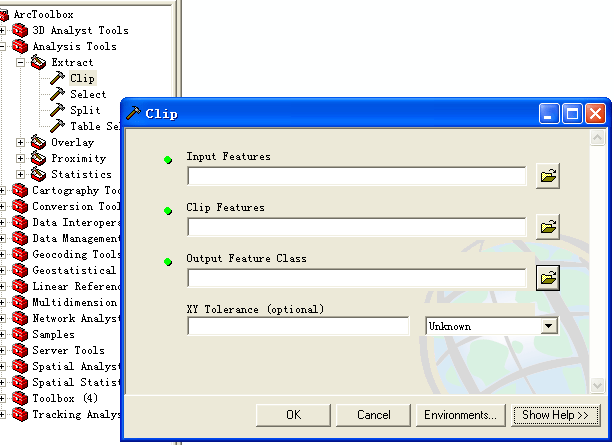
代码中Clip构造方法,以及clip对象参数的设置,均和ArcToolbox-->Clip工具相对应。
Geoprocessor类用来执行Geoprocessing相关工具的操作,geoprocessor的角色是一种helper对象,它的重载方法execute用来运行之前所定义的操作集。
GP.execute(clip, null);
com.esri.arcgis.geoprocessing.IGeoProcessorResult接口的对象可以捕获execute执行后的结果。
// Intialize the GeoprocessorGeoProcessor gp = new GeoProcessor();// 使用web service中的toolboxgp.addToolbox("http://flame7:8399/arcgis/services;GP/Bestpathtoolbox");// 导入本地的shape文件 ArrayList parameters = new ArrayList;parameters.add("C:\\sandiego\\source.shp"); parameters.add("C:\\sandiego\\destination.shp");// 捕获execute执行结果IGeoProcessorResult result;result = gp.execute("CalculateBestPath", parameters, null);
名字冲突
和OO语言处理名字冲突一样,当可能出现名字冲突时,可以使用全名来唯一指定所使用的工具:
ArcToolbox-->Analysis Tools-->Extract-->Clip
ArcToolbox-->Data Management-->Raster-->Clip
com.esri.arcgis.geoprocessing.tools.analysistools.Clipcom.esri.arcgis.geoprocessing.tools.datamanagementtools.Clip
Geoprocessing编程的时候,还可以使用AO作为输入的工具
// Initialize the Geoprocessor GPUtilities gpUtilities = new GPUtilities();IFeatureClass inputFeatureClass = gpUtilities.openFeatureClassFromString(inputData+"/canada/mjrroads.shp");IFeatureClass clipFeatureClass = gpUtilities.openFeatureClassFromString(inputData+"/canada/coasts.shp");Clip clip = new Clip(inputFeatureClass, clipFeatureClass, outputDirectory+"/clipOutput.shp");gp.execute(clip, null);
关于GPUtilities和Geoprocessor区别,可以看看这两段描述以及各自的类方法:
The GPUtilities object is mainly intended for developers building custom tools. For more information about building custom tools, refer to the technical document Building Geoprocessing Function Tools.
A geoprocessing tool is executed by a geoprocessor. The geoprocessor is a helper object that simplifies the task of executing tools. Toolboxes define the set of tools available for the geoprocessor. Toolboxes can be added and removed from the geoprocessor.
ArcToolbox工具都有自己的环境设置,一般情况下我们使用默认值,在AE中可以用setEnvironmentValue方法来设置环境变量的值
// Get the Cell Size environment valuegp.setEnvironmentValue("cellsize", Double.valueOf(10.0));String env = (String) gp.getEnvironmentValue("cellsize");// Set the output Coordinate System environment gp.setEnvironmentValue("outputCoordinateSystem", "c:/Program Files/ArcGIS/Coordinate Systems/Projected Coordinate Systems/UTM/Nad 1983/NAD 1983 UTM Zone 21N.prj");// Reset the environment values to their defaults.gp.resetEnvironments();
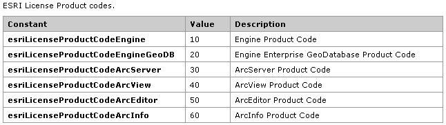
需要注意的是,在使用Geoprocessing建模进行各种空间操作时,我们需要相应的license授权来完成这些操作,如Spatial Join需要ArcInfo License,各种级别License描述可以参考下图:
Flyingis @ China
作者:Flyingis
ArcGIS使用者经常要面对大量的数据处理工作,如果要在自己的程序中使用Geoprocessing,更多的时候我们是要进行对数据进行批处理分析,Geoprocessing为我们提供了丰富的支持批处理的功能。
1.工作空间中查询所需数据
2.模型处理过程中各种输入、环境参数、字段映射的处理
3.枚举、循环执行
--------------------
1.工作空间中查询所需数据
要对数据进行批处理操作,首先需要知道工作空间中有哪些数据,怎么从工作空间大量数据中提取出我们所需要的数据。GeoProcessor类为我们提供了一些提取数据的方法。
listDatasets (string wildCard, string datasetType)
listFeatureClasses (string wildCard, string featureType, string dataset)
listRasters (string wildCard, string rasterType)
listTables (string wildCard, string tableType)
listToolboxes(string wildCard)
listWorkspaces (string wildCard, string workspaceType)
看看代码段怎么写:
//list all the featureClasses starting with cgp.setEnvironmentValue("workspace", inputWorkspace);IGpEnumList featureClasses = gp.listFeatureClasses("c*", "", "");String featureClass = featureClasses.next();System.out.println("-----------Feature Classes starting with c-----------"); while (! "".equals(featureClass)) {

 System.out.println(featureClass); featureClass = featureClasses.next();
 }
}
通过指定wildCard字符串,搜索所有"c"开头的feature class,将结果存放在com.esri.arcgis.geoprocessing.IGpEnumList枚举List中。看到IGpEnumList千万不要将它和Java数据结构中各种List相提并论,它仅仅具有顺序枚举next和重置查询指针reset的功能,可以被序列化。
再参考另外两个例子,相信对在工作空间中查询数据会有更多的认识。
返回所有面状要素
System.out.println("\n-----------Polygon Feature Classes-----------");gp.setEnvironmentValue("workspace", inputWorkspace);featureClasses = gp.listFeatureClasses("", "polygon", "");featureClass = featureClasses.next(); while (! "".equals(featureClass)) { System.out.println(featureClass); featureClass = featureClasses.next();}
返回所有TIF格式的Raster数据
// List all TIF files in the workspace and build pyramidsgp.setEnvironmentValue("workspace", inputWorkspace);IGpEnumList rasters = gp.listRasters("", "TIF");String raster = rasters.next(); BuildPyramids buildPyramids = new BuildPyramids(raster);while (! "".equals(raster)) { System.out.println("\n------------Building pyramids for: " + raster + "----------"); gp.execute(buildPyramids, null); raster = rasters.next();}
关于各种list方法TYPE类型,可以参考下表
| Method | Type Keywords |
| ListDatasets | All, Feature, Coverage, RasterCatalog, CAD, VPF, TIN, Topology |
| ListFeatureClasses | All, Point, Label, Node, Line, Arc, Route, Polygon, Region |
| ListFields | All, SmallInteger, Integer, Single, Double, String, Date, OID, Geometry, Blob |
| ListWorkspaces | All, Coverage, Access, SDE, Folder |
| ListTables | All, dBASE, INFO |
| ListRasters | All, ADRG, BIL, BIP, BSQ, BMP, CADRG, CIB, ERS, GIF, GIS, GRID, STACK, IMG, JPEG, LAN, SID, SDE, TIF, RAW, PNG, NITF |
2.模型处理过程中各种输入、环境参数的处理
Geoprocessing计算过程中会要求多个输入,通常可以用IGpEnumList来捕获。
 gp.setEnvironmentValue("workspace", multiWorkspace);IGpEnumList polygonFCs = gp.listFeatureClasses("", "polygon", "");String polygon = polygonFCs.next();String polygonsToUnion = "";
 while (! "".equals(polygon)){

 polygonsToUnion += polygon; polygon = polygonFCs.next();
 if (! "".equals(polygon)){
 polygonsToUnion += ";";
 }
} } Union union = new Union(polygonsToUnion,outputWorkspace+"/unioned.shp");gp.execute(union, null);
另外,可以使用表结构来保存每个输入的参数值,避免全部feature保存在一个字符串中。
// List all feature classes in the workspace.gp.setEnvironmentValue("workspace", multiWorkspace);IGpEnumList polygonFCs = gp.listFeatureClasses("", "polygon", ""); //make the value tableGPValueTable gpValueTable = new GPValueTable(); String polygon = polygonFCs.next();String row = null;while (! "".equals(polygon)){ if ("center".equals(polygon)){ row = polygon + " 1"; } else { row = polygon + " 2"; } gpValueTable.addRow(row); polygon = polygonFCs.next(); } Union union = new Union(gpValueTable, outputWorkspace+"/unionedValueTable.shp");gp.execute(union, null);
3.枚举、循环执行
前面两点都是针对一个Geoprocessing操作而言,如果需要多个操作,可以用基本程序语言来描述,这分为两种情况,一是多种Geoprocessing的数据处理,一种是同一Geoprocessing循环执行,相比ArcToolbox而言,这里体现的是程序代码带给我们的方便。
Flyingis @ China
ArcToolbox每个工具执行之后,都会向Geoprocessor返回消息,包括操作何时开始,使用哪些参数,操作的进度,以及可能出现的问题和错误。消息的种类包括常规消息、警告、错误,GPMessage类可以包含消息的文本及严重等级。
首先,Geoprocessor.getMessage()方法可以捕获最后一个工具执行后返回的错误消息
String messages = gp.getMessages(2);System.out.println(messages);如何使用GPMessage
//if there was an error then you want to loop the messages//returned by the geoprocessor to look for the errorGPMessages gpMessages = (GPMessages)gp.getReturnMessages();for(int i = 0; i gpMessages.getCount(); i++) { System.out.println(gpMessages.getMessage(i).getDescription());}可以看出,上面都是通过GeoProcessor的方法来获取消息,除此之外还可以使用IGeoProcessorResult接口,从功能上来说它们没有多少区别。
// Execute UnionIGeoProcessorResult pResult = gp.execute(uniontool, null); if (pResult.getMessageCount() > 0) { for(int i = 0; i <= pResult.getMessageCount() - 1; i++){ System.out.println(pResult.getMessageCount()); }}另外我们还可以自定义输出的方法,根据程序执行的过程,可以添加的方法有AddMessage、AddWarning、AddError。下面的示例将feature class从一个工作区复制到另外一个工作区,并跟踪显示每个文件复制的情况。
// Execute UnionIGeoProcessorResult pResult = gp.execute(uniontool, null); if (pResult.getMessageCount() > 0) { for(int i = 0; i <= pResult.getMessageCount() - 1; i++){ System.out.println(pResult.getMessageCount()); }}Flyingis @ China