
React,Echarts实现2D地图并且支持地图下钻
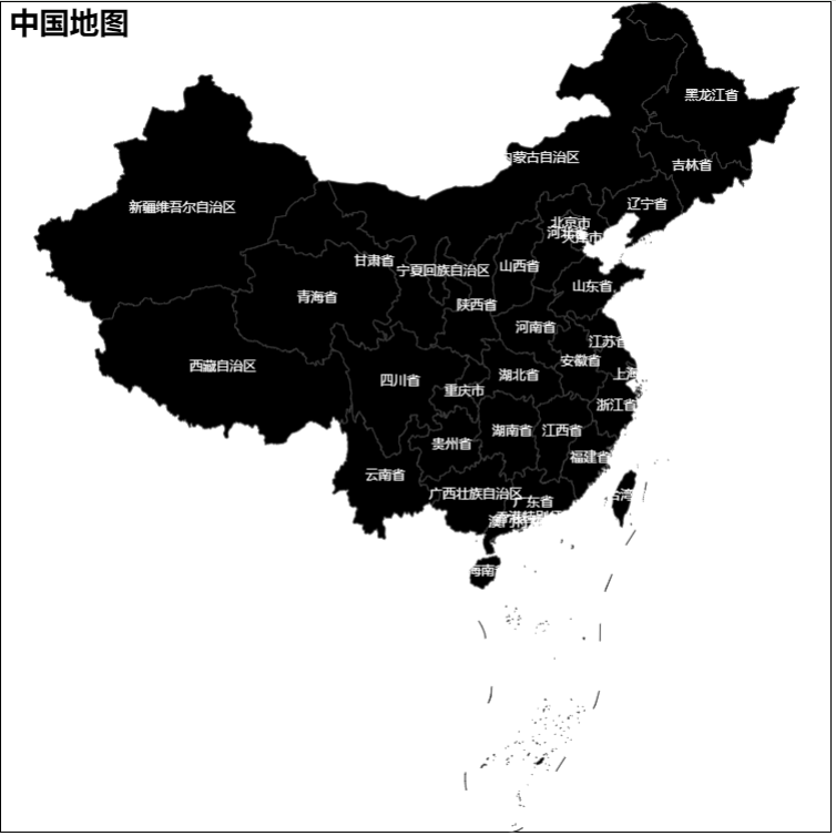
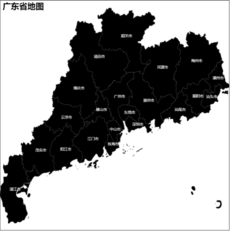
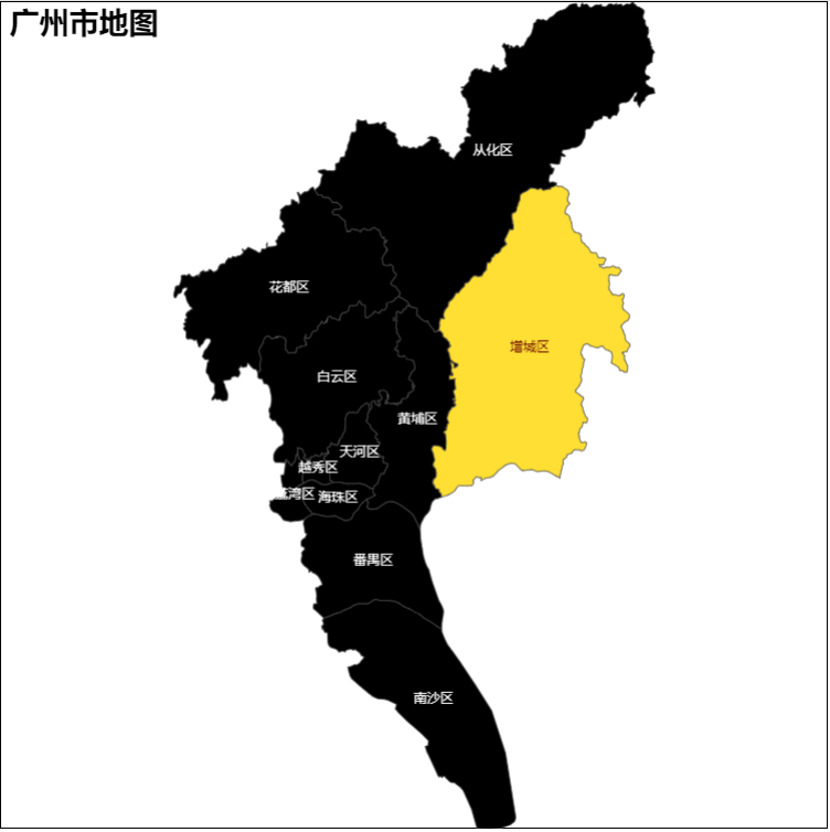
功能及效果图
- 渲染地图图表
- 点击某个地域,地图下钻,地图图像更新
- 支持全国,省及地市展示
实现过程
- 简去搭建react项目,引入echart库等步骤
- 收集地图数据
- 需要获取具体地点的GeoJson文件
- 通过https://datav.aliyun.com/portal/school/atlas/area_selector网站,免费下载相关数据的json文件
- 构建本地数据集
- ts 以广东省和广州市为例,最外层index.json为全国数据,每个文件夹内index.为省数据,具体命名文件夹为市数据
-
- 建立文件名映射表
geoMap.tstype stringKey = Record<string, string> export const provinceMap: stringKey = { 广东省: 'guangdong' } export const cityMap: stringKey = { 广州市: 'guangzhou' }
- ts 以广东省和广州市为例,最外层index.json为全国数据,每个文件夹内index.为省数据,具体命名文件夹为市数据
- 建立echart图表
- 除了最基础的图表建立过程,还需要用到echarts的
echarts.registerMap() - 配置图表option并建立
import geoJson from './geoJson.json'
const Map: React.FC = () => {
	const mapInstance = useRef<echarts.ECharts>()

	const option = {
		title: {
			text: '全国地图',
			textStyle: {
				color: '#000'
			},
			left: 'true'
		},
		series: [
			{
				name: '全国地图',
				type: 'map',
				mapType: 'map',
				scaleLimit: {
					min: 0.5,
					max: 10
				},
				label: {
					color: '#fff',
					show: true,
					position: [1, 100],
					fontSize: 8,
					offset: [2, 0],
					align: 'left'
				},
				itemStyle: {
					areaColor: '#000'
				},
				roam: true,
				zoom: 1.25,
				animation: true
			}
		]
	}

	useEffect(() => {
		echarts.registerMap('map', geoJson)
		mapInstance.current = echarts.init(document.getElementById('map') as HTMLDivElement)
		mapInstance.current?.setOption(option)
	},[])

	return <div id="map"></div>
}
- 除了最基础的图表建立过程,还需要用到echarts的
- 核心逻辑
- 设置一个数组存放地图路径,例如当前进入到广州市,则数组为
['中国','广东省','广州市']-
const [geoLevel, setGeoLevel] = useState<any>([])
const geoLevelRef = useRef<any>([])
-
- 建立响应式变量存放GeoJson文件的内容
-
const [geoData, setGeoData] = useState<any>()
const geoRef = useRef<any>(null)
-
- 编写获取对应GeoJson文件的路径方法
-
//通过路径数组的长度,判断当前节点属于国,省还是市
//通过之前建立的geoJsonMap表,进行中文和英文配对,获取文件名
const geoJsonPath = () => {
    const length = geoLevelRef.current?.length || 0
    const baseDir = '/src/config/mapData/'
    const province = provinceMap[geoLevelRef.current[1]]
    const city = cityMap[geoLevelRef.current[2]]
    switch (length) {
        case 1:
            return `${baseDir}index.json`
            case 2:
            return `${baseDir}${province}/index.json`
            case 3:
            return `${baseDir}${province}/${city}.json`
            default:
            return `${baseDir}index.json`
    }
}
-
- 编写获取GeoJson文件内容的方法
-
//childrenName:当前点击地图位置的名称(例:广东省) action:当前操作是下钻还是上行
//数据下钻则对level数组进行添加,数据上行则对level数组进行删除
//最后通过fetch获取文件内容
const updateGeoData = (
	childrenName: string = '中国',
	action: boolean = true
) => {
	if (action) {
		setGeoLevel((l: any) => {
			return [...l, childrenName]
		})
		geoLevelRef.current = [...geoLevelRef.current, childrenName]
	} else {
		setGeoLevel((l: any) => {
			return l.slice(0, -1)
		})
		geoLevelRef.current = geoLevelRef.current.slice(0, -1)
	}
	fetch(geoJsonPath())
		.then(res => res.json())
		.then(res => {
			setGeoData(res)
			geoRef.current = res
		})
}
-
- 设置一个数组存放地图路径,例如当前进入到广州市,则数组为
- 最后配置地图左右键点击事件
-
useEffect(() => {
	//阻止浏览器默认的右键事件
	document.getElementById('map')!.oncontextmenu = function () {
		return false
	}

	//绑定左键事件,当地图显示市级数据时无法再进行数据下钻
	mapInstance.current?.on('click', (params: any) => {
		if (geoLevelRef.current.length >= 3) return
		updateGeoData(params?.name)
	})

	//绑定右键事件,当数据上行到国数据时无法再进行数据上行
	mapInstance.current?.on('contextmenu', (params: any) => {
		if (geoLevelRef.current.length === 1) return
		updateGeoData(params?.name, false)
	})

	//每当地图数据更新时,重新绑定事件,卸载旧的事件监听,否则会出现多次执行的情况
	return () => {
		if (mapInstance.current) {
			mapInstance.current.off('contextmenu')
			mapInstance.current.off('click')
		}
	}
}, [])
-
- 完整代码
-
import * as echarts from 'echarts'
import { useEffect, useRef, useState } from 'react'
import { provinceMap, cityMap } from '../../config/mapData/geoMap'

const MyMap: React.FC = () => {
	const mapInstance = useRef<echarts.ECharts>()
	const [geoData, setGeoData] = useState<any>()
	const geoRef = useRef<any>(null)
	const [geoLevel, setGeoLevel] = useState<any>([])
	const geoLevelRef = useRef<any>([])

	const option = {
		title: {
			textStyle: {
				color: '#000'
			},
			left: 'center'
		},
		series: [
			{
				name: '全国地图',
				type: 'map',
				mapType: 'map',
				scaleLimit: {
					min: 0.5,
					max: 10
				},
				label: {
					color: '#fff',
					show: true,
					position: [1, 100],
					fontSize: 8,
					offset: [2, 0],
					align: 'left'
				},
				itemStyle: {
					areaColor: '#000'
				},
				roam: true,
				zoom: 1.25,
				animation: true
			}
		]
	}

	const geoJsonPath = () => {
		const length = geoLevelRef.current?.length || 0
		const baseDir = '/src/config/mapData/'
		const province = provinceMap[geoLevelRef.current[1]]
		const city = cityMap[geoLevelRef.current[2]]
		switch (length) {
			case 1:
				return `${baseDir}index.json`
			case 2:
				return `${baseDir}${province}/index.json`
			case 3:
				return `${baseDir}${province}/${city}.json`
			default:
				return `${baseDir}index.json`
		}
	}

	const updateGeoData = (
		childrenName: string = '中国',
		action: boolean = true
	) => {
		setGeoLevel((prevLevel: any) => {
			const newLevel = action
				? [...prevLevel, childrenName]
				: prevLevel.slice(0, -1)
			geoLevelRef.current = newLevel
			return newLevel
		})
	}

	useEffect(() => {
		const path = geoJsonPath()
		if (geoLevel.length !== 0) {
			fetch(path)
				.then(res => res.json())
				.then(data => {
					setGeoData(data)
					geoRef.current = data
				})
		}
	}, [geoLevel])

	useEffect(() => {
		updateGeoData()
	}, [])

	useEffect(() => {
		document.getElementById('map')!.oncontextmenu = () => false
	}, [])

	useEffect(() => {
		if (geoData) {
			echarts.registerMap('map', geoRef.current as any)
			mapInstance.current = echarts.init(
				document.getElementById('map') as HTMLDivElement
			)
			option.title.text = `${geoRef.current?.name}地图` || '地图'
			mapInstance.current?.setOption(option)
		}
	}, [geoData])

	useEffect(() => {
		mapInstance.current?.on('click', (params: any) => {
			if (geoLevelRef.current.length >= 3) return
			updateGeoData(params?.name)
		})
		mapInstance.current?.on('contextmenu', (params: any) => {
			if (geoLevelRef.current.length === 1) return
			updateGeoData(params?.name, false)
		})
		return () => {
			mapInstance.current?.off('click')
			mapInstance.current?.off('contextmenu')
		}
	}, [geoData])

	useEffect(() => {
		window.addEventListener('resize', () => {
			mapInstance.current?.resize()
		})
		return () => {
			window.removeEventListener('resize', () => {
				mapInstance.current?.resize()
			})
		}
	}, [])

	return <div style={{ width: '100%', height: '100%' }} id="map"></div>
}
export default MyMap
-

遇坑
- 单独依赖useState()的响应式数据无法实现更新地图
- setState是异步更新,在调用setState之后访问state拿到的是旧的数据。
- 每次点击后都会通过setGeoLevel去更新geoLevel数组,然后立刻访问geoLevel获取GeoJson文件。但是由于异步更新,每次拿到的都是当前的快照数据。
通过建立ref变量,更新state数据的同时也更新ref变量。因为useEffect将state数据作为依赖项用来更新数据,所以单独使用ref无法实现更新
- geoJsonPath一开始使用了useMemo进行包裹,并且将geoLevel作为依赖项,相关数据也从geoLevel进行获取。结果是无法获取最新值也无法通过依赖项监听更新数据
将geoJsonPath改写为函数,level值通过geoLevelRef进行获取,每次获取路径都会重新调用该函数,所以每次都能获取到新值
- 对地图绑定了点击事件后,点击后会重复执行。
需要利用return,在组件重新渲染前解除点击事件的监听
mapInstance.current.off('click')
- fetch和import获取静态文件的区别
fetch模拟网络请求,需要配置完成的请求地址后缀。如
/src/config/mapData/guangdong/gaungzhou.jsonimport是ESM引入文件语句,可以通过文件路径进行获取。如
../../config/mapData/guangdong/guangzhou.json

 浙公网安备 33010602011771号