
ifc4x3 附录E示例-地理参考-1
ifc4x3 附录E示例-地理参考-1
示例概述
意图
此场景封装了使用正确地理参考设置的模型。
它将项目的基点放在慕尼黑技术大学的入口处,将坐标轴与东部和北部对齐,并将项目的单位设置为国际单位制。
先决条件
此场景基于以下其他场景:
- ProjectSetup-1
- Tin-1
所容纳之物
该方案涵盖以下概念和/或IFC实体:
- georeferencing metadata
- representation of
IfcSolidStratum:
支持文件
以下文件对应于此场景:
Following files correspond to this scenario:
| Filename | Description |
|---|---|
UT_GeoRef_1.ifc |
将导出的内容作为IFC文档 |
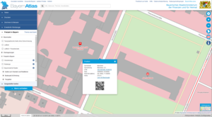
UT_GeoRef_1_1.png |
来自BayernAtlas的TUM入口屏幕截图 |
UT_GeoRef_1_2.jpg |
地理参考图元的示意图表示 |
IFC-SPF source
ISO-10303-21;

/* ------- This file was produced manually for IFC Infra Extension Deployment project. --------- */
/* ------- The file should come with a README.md with supplementing info. ---------------------- */
/* ------- Stefan Jaud, stefan.jaud@tum.de, 2020.07.27. ---------------------------------------- */

HEADER;
FILE_DESCRIPTION (('ViewDefinition [Ifc4X3NotAssigned]'), '2;1');
FILE_NAME ('UT_GeoRef_1.ifc', '2020-07-27T12:00:00', ('Stefan Jaud'), ('bSI Infra Extension Deployment project'), 'manual text editing', 'SublimeText 3.0', 'GitHub pull request');
FILE_SCHEMA (('IFC4X3_RC2'));
ENDSEC;

DATA;

/* ------- UT ProjectSetup_1 ------------------------------------------------------------------- */
#1 = IFCDIMENSIONALEXPONENTS(0, 0, 0, 0, 0, 0, 0);
#2 = IFCDIRECTION((1., 0., 0.));
#3 = IFCDIRECTION((0., 1., 0.));
#4 = IFCDIRECTION((0., 0., 1.));
#5 = IFCCARTESIANPOINT((0., 0., 0.));
#16 = IFCPROJECT('2DAvEupIz0HQr73cMaawtY', $, 'GeoRef_1', 'The bare minimum of an IFC file exchange with only georeferencing meta data.', $, $, $, (#28), #17);
#17 = IFCUNITASSIGNMENT((#18, #19, #20, #24, #25, #26, #27));
#18 = IFCSIUNIT(*, .LENGTHUNIT., $, .METRE.);
#19 = IFCSIUNIT(*, .AREAUNIT., $, .SQUARE_METRE.);
#20 = IFCSIUNIT(*, .VOLUMEUNIT., $, .CUBIC_METRE.);
#22 = IFCSIUNIT(*, .PLANEANGLEUNIT., $, .RADIAN.);
#23 = IFCMEASUREWITHUNIT(IFCPLANEANGLEMEASURE(0.017453292519943295), #22);
#24 = IFCCONVERSIONBASEDUNIT(#1, .PLANEANGLEUNIT., 'degree', #23);
#25 = IFCSIUNIT(*, .MASSUNIT., .KILO., .GRAM.);
#26 = IFCSIUNIT(*, .TIMEUNIT., $, .SECOND.);
#27 = IFCMONETARYUNIT('EUR');
#28 = IFCGEOMETRICREPRESENTATIONCONTEXT($, 'Model', 3, 1.E-6, #29, #54);
#29 = IFCAXIS2PLACEMENT3D(#5, #4, #2);

/* ------- UT GeoRef_1 ------------------------------------------------------------------------- */
/* ------- ProjectedCRS provides information about the underlying geodetic --------------------- */
/* ------- coordinate reference system --------------------------------------------------------- */
#30 = IFCPROJECTEDCRS('EPSG:5834', 'DB_REF / 3-degree Gauss-Kruger zone 4 (E-N) + DHHN92 height', 'EPSG:5684', 'EPSG:5783', 'Gauss-Kruger', '4', #18);
/* ------- MapConversion provides information about the global-to-local transformation --------- */
#31 = IFCMAPCONVERSION(#28, #30, 4468005., 5334600., 515., 1., 0., 1.);

/* ------- UT Tin_1 ---------------------------------------------------------------------------- */
/* ------- IfcSite is the top most element in the spatial structure ---------------------------- */
#32 = IFCSITE('27H$neCQf1NwtmczxBInPR', $, $, $, $, #33, #40, $, .ELEMENT., $, $, $, $, $);
/* ------- The IfcSite's placement is the top-most placement and uses the same ----------------- */
/* ------- IfcAxis2Placement as IfcGeometricRepresentationContext does ------------------------- */
#33 = IFCLOCALPLACEMENT($, #29);
/* ------- Project/Spatial structure ----------------------------------------------------------- */
#35 = IFCRELAGGREGATES('3Hu7f6BmT14B_XS9yS78Jr', $, $, $, #16, (#32));

/* ------- Simple representation of the construction site: ------------------------------------- */
/* ------- Square with side=1km centred at (0,0,0) (local coordinates) ------------------------- */
/* ------- or centred at (4468005., 5334600., 515.) (global coordinates) ----------------------- */
#40= IFCPRODUCTDEFINITIONSHAPE($,$,(#41));
#41= IFCSHAPEREPRESENTATION(#28,'Surface','Tessellation',(#42));
#42= IFCTRIANGULATEDFACESET(#43,$,.F.,((1,2,3),(1,3,4)),$);
#43= IFCCARTESIANPOINTLIST3D(((-500.,-500.,0.),(500.,-500.,0.),(500.,500.,0.),(-500.,500.,0.)),$);

/* ------ IfcSolidStratum represents the top most layer of terrain ----------------------------- */
#50 = IFCSOLIDSTRATUM('28H$neCQf1NwtmczxBInPR', $, $, $, $, #53, #40, $);
/* ------ Spatial inclusion in the project ----------------------------------------------------- */
#51 = IFCRELCONTAINEDINSPATIALSTRUCTURE('3Hu7f6BmT14B_XS9yS78Jq', $, $, $, (#50), #32);
/* ------ Placement is relative to that of IfcSite according to the spatial structure ---------- */
/* ------ The way it is modelled, there is no offset and no rotation. -------------------------- */
#52 = IFCAXIS2PLACEMENT3D(#5, #4, #2);
#53 = IFCLOCALPLACEMENT(#33, #52);

/* ------ TrueNorth of the geometric context must be a 2D vector ------------------------------- */
#54 = IFCDIRECTION((0.,1.));

ENDSEC;
##########################
QQ 3087438119

 浙公网安备 33010602011771号