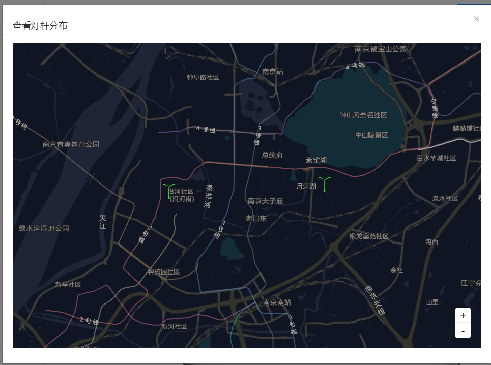
使用L7·蚂蚁地理空间数据可视化实现灯杆查看

  1 <template>
  2   <div v-if="showMapDialog">
  3     <el-dialog title="查看灯杆分布" :visible="visible" @close="closeDia">
  4       <div id="map"></div>
  5     </el-dialog>
  6   </div>
  7 </template>
  8
  9 <script>
 10 import { Scene, Marker, MarkerLayer, PointLayer, Popup } from "@antv/l7";
 11 import { GaodeMap } from "@antv/l7-maps";
 12 import locationImg from "@/modules/intelLamp/assets/image/icon-light.png";
 13 export default {
 14   props: {
 15     showMapDialog: {
 16       type: Boolean,
 17       default() {
 18         return false; // 帐号状态 true正常 false异常
 19       }
 20     },
 21     coordinateList: {
 22       type: Array,
 23       default() {
 24         return [];
 25       }
 26     }
 27   },
 28   data() {
 29     return {
 30       scene: null,
 31       visible: false,
 32       clusterMarkerLayer: null
 33     };
 34   },
 35   watch: {
 36     showMapDialog(val) {
 37       this.visible = val;
 38       if (this.visible) {
 39         this.$nextTick(() => {
 40           this.initMap();
 41         });
 42       }
 43     }
 44   },
 45   beforeDestroy() {
 46     if (this.scene) {
 47       this.scene.destroy();
 48     }
 49   },
 50   methods: {
 51     closeDia() {
 52       this.$emit("update:showMapDialog", false);
 53     },
 54     getBounds(
 55       nodes,
 56       defineKey = {
 57         x: "lng",
 58         y: "lat"
 59       }
 60     ) {
 61       let min_x, min_y, max_x, max_y;
 62       nodes.forEach(node => {
 63         min_x = min_x ? min_x : node[defineKey.x];
 64         min_x = min_x < node[defineKey.x] ? min_x : node[defineKey.x];
 65         min_y = min_y ? min_y : node[defineKey.y];
 66         min_y = min_y < node[defineKey.y] ? min_y : node[defineKey.y];
 67         max_x = max_x ? max_x : node[defineKey.x];
 68         max_x = max_x > node[defineKey.x] ? max_x : node[defineKey.x];
 69         max_y = max_y ? max_y : node[defineKey.y];
 70         max_y = max_y > node[defineKey.y] ? max_y : node[defineKey.y];
 71       });
 72       let offset_x = max_x - min_x;
 73       min_x = min_x - offset_x;
 74       max_x = max_x + offset_x;
 75       let offset_y = max_y - min_y;
 76       min_y = min_y - offset_y;
 77       max_y = max_y + offset_y;
 78
 79       return [
 80         [min_x, min_y],
 81         [max_x, max_y]
 82       ];
 83     },
 84     // 删除聚合图层
 85     removeClusterMarkerLayer() {
 86       if (this.clusterMarkerLayer) {
 87         this.clusterMarkerLayer.destroy();
 88         this.scene.removeMarkerLayer(this.clusterMarkerLayer);
 89       }
 90     },
 91     initMap() {
 92       this.scene = new Scene({
 93         id: "map",
 94         logoVisible: false, // 关闭L7的logo
 95         map: new GaodeMap({
 96           style: "dark",
 97           center: [118.788336, 32.022806],
 98           pitch: 0,
 99           zoom: 12,
100           token: "***********"
101         })
102       });
103       // 加载的AMap会挂载在全局的window对象上
104       this.scene.on("loaded", () => {
105         window.AMap.plugin(["AMap.ToolBar"], () => {
106           this.scene.map.addControl(new AMap.ToolBar());
107         });
108         // 添加 Marker 统一管理图层
109         if (this.clusterMarkerLayer) {
110           this.removeClusterMarkerLayer();
111         }
112         this.clusterMarkerLayer = new MarkerLayer();
113         for (let i = 0; i < this.coordinateList.length; i++) {
114           const el = document.createElement("label");
115           let popup = new Popup({
116             anchor: "top"
117           })
118             .setText(this.coordinateList[i].name)
119             .setLngLat({
120               lng: this.coordinateList[i].lng,
121               lat: this.coordinateList[i].lat
122             });
123           el.className = "labelclass";
124           el.style.background = `url(${locationImg}) no-repeat`;
125           el.style.width = `30px`;
126           el.style.height = `30px`;
127           el.style.backgroundSize = "100%";
128           const marker = new Marker({
129             element: el
130           })
131             .setLnglat({
132               lng: this.coordinateList[i].lng,
133               lat: this.coordinateList[i].lat
134             })
135             .setPopup(popup);
136           this.clusterMarkerLayer.addMarker(marker);
137         }
138         this.scene.addMarkerLayer(this.clusterMarkerLayer);
139         let bounds = this.getBounds(this.coordinateList);
140         this.scene.fitBounds(bounds);
141       });
142     }
143   }
144 };
145 </script>
146
147 <style scoped lang="scss">
148 #map {
149   position: relative;
150   height: 600px;
151 }
152 </style>
分类:
gis或3d


【推荐】国内首个AI IDE,深度理解中文开发场景,立即下载体验Trae
【推荐】编程新体验,更懂你的AI,立即体验豆包MarsCode编程助手
【推荐】抖音旗下AI助手豆包,你的智能百科全书,全免费不限次数
【推荐】轻量又高性能的 SSH 工具 IShell:AI 加持,快人一步
· 25岁的心里话
· 闲置电脑爆改个人服务器(超详细) #公网映射 #Vmware虚拟网络编辑器
· 基于 Docker 搭建 FRP 内网穿透开源项目(很简单哒)
· 零经验选手,Compose 一天开发一款小游戏!
· 一起来玩mcp_server_sqlite,让AI帮你做增删改查!!
2023-04-11 el-table在flex布局下宽度不能自适应的解决方法