cesium结合geoserver利用WFS服务实现图层新增(附源码下载)
前言
cesium 官网的api文档介绍地址cesium官网api,里面详细的介绍 cesium 各个类的介绍,还有就是在线例子:cesium 官网在线例子,这个也是学习 cesium 的好素材。
内容概览
1.cesium结合geoserver利用WFS服务实现图层新增功能
2.源代码demo下载
效果图如下:
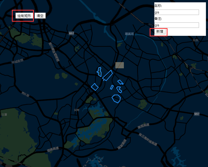
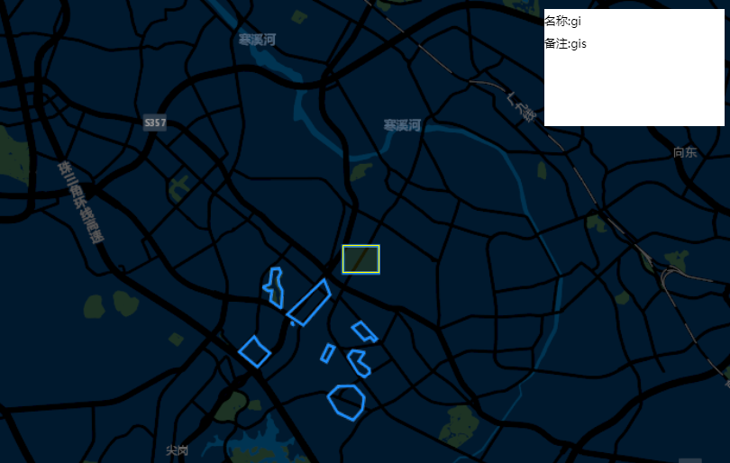
本篇主要是cesium通过调用geoserver发布的地图服务WFS来达到图层新增记录的目的。与GeoServer的WFS进行基于Rest交互关键就在于请求参数,值得注意的是这些请求最好采用POST方法发送。查询可以采用json,但增加,删除,修改都只能采用XML形式Transaction
-
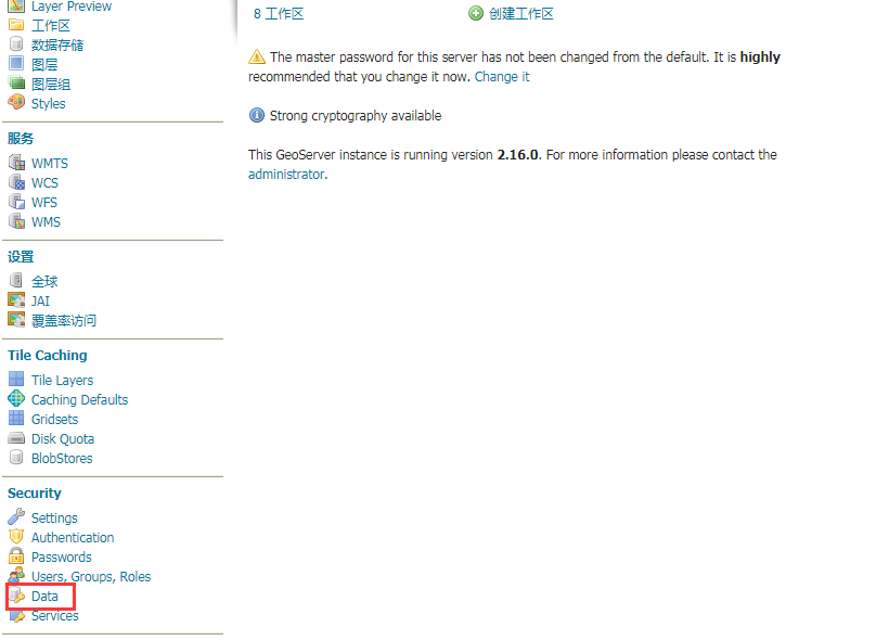
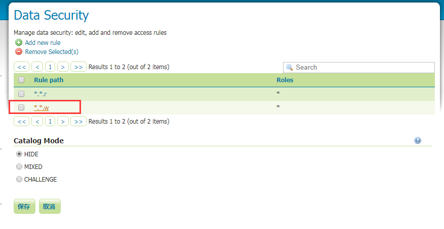
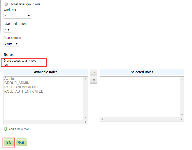
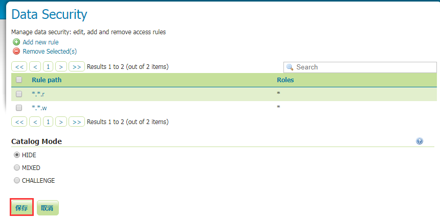
geoserver默认WFS服务是没有编辑操作权限的,所以需要在geoserver设置权限,允许编辑操作才行,截图如下:
-
部分核心代码:
//绘制geojson图层样式
var geoJsonStyle = {
stroke: Cesium.Color.YELLOW,
strokeWidth: 3,
fill: Cesium.Color.YELLOW.withAlpha(0.1)
};
var geoserverUrl = 'http://localhost:8080/geoserver/WebGIS';
var image_Source = new Cesium.UrlTemplateImageryProvider({
//url: 'http://mt0.google.cn/vt/lyrs=t,r&hl=zh-CN&gl=cn&x={x}&y={y}&z={z}',
//url: 'https://server.arcgisonline.com/arcgis/rest/services/World_Imagery/MapServer/tile/{z}/{y}/{x}',
url: "http://map.geoq.cn/ArcGIS/rest/services/ChinaOnlineStreetPurplishBlue/MapServer/tile/{z}/{y}/{x}",
//tilingScheme : new Cesium.GeographicTilingScheme(),
credit: ''
});
var viewer = new Cesium.Viewer('map', {
geocoder: false,
homeButton: false,
sceneModePicker: false,
fullscreenButton: false,
vrButton: false,
baseLayerPicker: false,
infoBox: false,
selectionIndicator: false,
animation: false,
timeline: false,
shouldAnimate: true,
navigationHelpButton: false,
navigationInstructionsInitiallyVisible: false,
imageryProvider: image_Source
});

//加载geoserver wms服务
var wms = new Cesium.WebMapServiceImageryProvider({
url: geoserverUrl+'/wms',
layers: 'WebGIS:testLayer',
parameters: {
service : 'WMS',
format: 'image/png',
transparent: true,
}
});
viewer.imageryLayers.addImageryProvider(wms);


viewer._cesiumWidget._creditContainer.style.display = "none";
viewer.scene.globe.enableLighting = false;
//viewer.scene.globe.depthTestAgainstTerrain = true;
viewer.scene.globe.showGroundAtmosphere = false;

viewer.camera.flyTo({
destination : Cesium.Cartesian3.fromDegrees(113.90271877, 22.95186415,30000.0)
});


var handler = new Cesium.ScreenSpaceEventHandler(viewer.scene.canvas);
var ellipsoid = viewer.scene.globe.ellipsoid;
handler.setInputAction(function (movement) {
//通过指定的椭球或者地图对应的坐标系,将鼠标的二维坐标转换为对应椭球体三维坐标
cartesian = viewer.camera.pickEllipsoid(movement.position, ellipsoid);
if (cartesian) {
//将笛卡尔坐标转换为地理坐标
var cartographic = ellipsoid.cartesianToCartographic(cartesian);
//将弧度转为度的十进制度表示
var longitudeString = Cesium.Math.toDegrees(cartographic.longitude);
var latitudeString = Cesium.Math.toDegrees(cartographic.latitude);
var point = longitudeString + ',' + latitudeString;
queryByPoint(point,'testLayer',callbackLastQueryWFSService);
}
}, Cesium.ScreenSpaceEventType.LEFT_CLICK);


var drawTool = new DrawTool({
viewer: viewer,
hasEdit: false
});


//绘制矩形
$("#rect_btn").click(function(){
//clearMap()
if (!drawTool) return;
drawTool.startDraw({
type: "rectangle",
style: {
heightReference: Cesium.HeightReference.CLAMP_TO_GROUND,
//material:Cesium.Color.WHITE
material:Cesium.Color.fromRgba(0x67ADDFFF)
},
success: function (evt) {
//console.log('evt',evt);
var leftup = evt.leftup;
var rightdown = evt.rightdown;
//世界坐标转地理坐标(弧度)
var leftupcartographic = viewer.scene.globe.ellipsoid.cartesianToCartographic(leftup);
var rightdowncartographic = viewer.scene.globe.ellipsoid.cartesianToCartographic(rightdown);
//console.log('leftupcartographic',leftupcartographic);
//地理坐标(弧度)转经纬度坐标
var leftuppoint = [leftupcartographic.longitude / Math.PI * 180, leftupcartographic.latitude / Math.PI * 180];
console.log('leftuppoint',leftuppoint);
var rightdownpoint = [rightdowncartographic.longitude / Math.PI * 180, rightdowncartographic.latitude / Math.PI * 180];
console.log('rightdown',rightdown);
var extent = [leftuppoint[0].toFixed(6),leftuppoint[1].toFixed(6),rightdownpoint[0].toFixed(6),rightdownpoint[1].toFixed(6)];
var polygon = null;
if(extent && extent.length>0){
//构造polygon
polygon = '';
polygon += extent[0] + ',' + extent[1] + ' ' ;
polygon += extent[2] + ',' + extent[1] + ' ' ;
polygon += extent[2] + ',' + extent[3] + ' ' ;
polygon += extent[0] + ',' + extent[3] + ' ' ;
polygon += extent[0] + ',' + extent[1] + ' ' ;
}
console.log('polygon',polygon);
if(polygon){
var content = '<span>名称:</span><input type="text" id="estate_num" /></br><span>备注:</span><input type="text" id="holder_nam" /></br><button type="button" id="addBtn">新增</button>';
$("#infowindow").show();
$("#infowindow").empty();
$("#infowindow").append(content);
$("#addBtn").click(function(){
console.log('点击事件响应');
addLayers(polygon,$("#estate_num").val(),$("#holder_nam").val(),callbackAddLayersWFSService);
});
}
}
});
});
- 图层新增函数
/*图层新增
*@method addLayers
*@param polygon 图形
*@param fieldValue1 字段1值
*@param fieldValue2 字段2值
*@return callback
*/
function addLayers(polygon,fieldValue1,fieldValue2, callback){
var xml = '<wfs:Transaction service="WFS" version="1.0.0" xmlns:opengis="http://webgis.com" xmlns:wfs="http://www.opengis.net/wfs" xmlns:ogc="http://www.opengis.net/ogc" xmlns:gml="http://www.opengis.net/gml" xmlns:xsi="http://www.w3.org/2001/XMLSchema-instance" xsi:schemaLocation="http://www.opengis.net/wfs http://schemas.opengis.net/wfs/1.0.0/WFS-basic.xsd">';
……
更多详情见下面链接文章:
文章提供源码,对本专栏感兴趣的话,可以关注一波
GIS之家作品店铺:GIS之家作品店铺
GIS之家源码咨询:GIS之家webgis入门开发系列demo源代码咨询
扫码关注GIS之家微信公众号,回复“gis”可免费获取地图数据以及arcgis系列安装包等资源
GIS之家源码咨询:GIS之家webgis入门开发系列demo源代码咨询
扫码关注GIS之家微信公众号,回复“gis”可免费获取地图数据以及arcgis系列安装包等资源


