ENVI 5.2光谱指数工具(Spectral Indices)
1、新增指数列表
-
Difference Vegetation Index 差异植被指数
-
Green Ratio Vegetation Index 绿度比值植被指数
-
Green Vegetation Index 绿度植被指数
-
Leaf Area Index 叶面积指数
-
Modified Chlorophyll Absorption Ratio Index
改进叶绿素吸收比值指数 -
Modified Chlorophyll Absorption Ratio Index - Improved
改进叶绿素吸收比值指数(增强) -
Modified Non-Linear Index
改进非线性指数 -
Modified Simple Ratio
改进简单比值指数 -
Modified Triangular Vegetation Index
改进三角植被指数 -
Modified Triangular Vegetation Index - Improved
改进三角植被指数(增强) -
Non-Linear Index 非线性指数
-
Normalized Multi-band Drought Index 归一化多波段干旱指数
-
Optimized Soil Adjusted Vegetation Index 最佳土壤调整植被指数
-
Red Green Ratio Index 红绿波段比值指数
-
Soil Adjusted Vegetation Index 土壤调整植被指数
-
Simple Ratio 单一比值指数
-
Transformed Chlorophyll Absorption Reflectance Index 转换叶绿素吸收反射比指数
-
Triangular Vegetation Index 三角植被指数
-
Visible Atmospherically Resistant Index 可视化气压阻抗指数
2、特征指数
-
Burn Area Index 燃烧面积指数
-
Clay Minerals Ratio 黏土矿物比值指数
-
Ferrous Minerals Ratio 铁矿比值指数
-
Iron Oxide Ratio 氧化铁比值指数
-
Normalized Burn Ratio 归一化燃烧比值指数
-
Normalized Difference Built-Up Index 归一化建筑物指数
-
Normalized Difference Snow Index 归一化雪盖指数
-
WorldView Built-Up Index WV 建筑物指数
-
WorldView New Iron Index WV 含铁指数
-
WorldView Non-Homogenous Feature Difference WV 均匀性特征差异指数
-
WorldView Soil Index WV 土壤指数
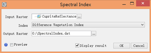
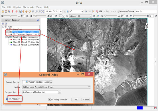
3、ENVI 5.2波谱指数计算
利用
-
在Toolbox选择
Band Algebra > Spectral Index。 -
双击Spectral Index.弹出对话框,在对话框中选择输入的影像文件以及计算用的植被指数。注意:输入的影像文件必须包含有中心波长元文件;
-
选择一种需要计算的指数。并非所有的输入影像都可以计算ENVI提供的指数计算,在不能满足实际应用时可采用ENVIQuerySpectralIndices
Task编写计算脚本,从而计算所需要的指数文件。 -
选择输出文件路径以及名称。

4、ENVI QuerySpectralIndices API
; Start the applicatione = ENVI(); Open an input fileFile = Filepath('qb_boulder_msi', Subdir=['data'], $Root_Dir=e.Root_Dir)Raster = e.OpenRaster(File); Process a spatial subsetSubset = ENVISubsetRaster(Raster, Sub_Rect=[600,200,799,399]); Get the task from the catalog of ENVITasksTask = ENVITask('QuerySpectralIndices'); Define inputsTask.INPUT_RASTER = Subset; Run the taskTask.Execute; Get the task from the catalog of ENVITasksTask2 = ENVITask('SpectralIndices'); Define inputsTask2.INPUT_RASTER = SubsetTask2.INDEX = Task.AVAILABLE_INDICES; Run the taskTask2.Execute; Get the data collectionDataColl = e.Data; Add the output to the data collectionDataColl.Add, Task2.OUTPUT_RASTER; Display the resultView1 = e.GetView()Layer1 = View1.CreateLayer(Task2.OUTPUT_RASTER); Print the available indices to the; ENVI command lineTask.AVAILABLE_INDICES

【推荐】国内首个AI IDE,深度理解中文开发场景,立即下载体验Trae
【推荐】编程新体验,更懂你的AI,立即体验豆包MarsCode编程助手
【推荐】抖音旗下AI助手豆包,你的智能百科全书,全免费不限次数
【推荐】轻量又高性能的 SSH 工具 IShell:AI 加持,快人一步
· 震惊!C++程序真的从main开始吗?99%的程序员都答错了
· 别再用vector<bool>了!Google高级工程师:这可能是STL最大的设计失误
· 单元测试从入门到精通
· 【硬核科普】Trae如何「偷看」你的代码?零基础破解AI编程运行原理
· 上周热点回顾(3.3-3.9)