用d3制作一个基于GeoJSON的中国地图
基础知识
地图数据
数据格式有两种:GeoJSON,TopoJSON。其中,GeoJSON是描述地理信息的一种基本格式,TopoJSON是作者制定的格式。我主要了解GeoJSON。
获取数据
可自行百度
中国的数据chain.geo.json放在附录里面
示例
{
	"type": "FeatureCollection",
	"features": [
        {
			"type": "Feature",
			"id": "shang_hai",
			"properties": {
				"name": "上海",
				"cp": [121.4648, 31.2891],
				"childNum": 19
			},
			"geometry": {
				"type": "Polygon",
				"coordinates": [[[120.9375, 31.0254],[121.2012, 31.4648],
				[121.377, 31.5088],[121.1133, 31.7285],[121.2012, 31.8604],[121.9922, 31.5967],
				[121.9043, 31.1572],[121.9922, 30.8057],[121.2891, 30.6738],[120.9375, 31.0254]
					]
				]
			}
		}, {
			"type": "Feature",
			"id": "xiang_gang",
			"properties": {
				"name": "香港",
				"cp": [114.2578, 22.3242],
				"childNum": 1
			},
			"geometry": {
				"type": "Polygon",
				"coordinates": [.....]
			}
		},
		......
		]
		"srcSize": {
		"left": 243.4766,
		"top": 36.4307,
		"width": 61.6113,
		"height": 35.4638
	}
}
GeoJSON数据解释
它是用于描述地理空间信息的数据格式
- FeatureCollection:特征集合
- type:GeoJSON对象都有type属性,type的值有多种
- Feature:是type的值之一,Feature特征对象必须包含变量geometry,properties
- geometry:几何体
- properties:值可以是任意JSON对象或null
- Polygon:面
所以china.geo.json文件里,有一个对象,该对象的type值为特征集合FeatureCollection,其成员Feature的每一项描述一个省的地理信息,特征对象properties里面包含该省的名称,id号。geometry包含该省的地理信息。
地图制作
在一个矩形区域中,划伤中国大陆和港澳台,再在矩形的右下角添加一个小框,里面绘制南海诸岛。南海岛屿需要单独制作。
基础图像
<!DOCTYPE html>
<html>
	<head>
		<meta charset="utf-8">
		<title>中国地图</title>
		<script src="http://d3js.org/d3.v3.min.js"></script>
	</head>
	<body>
		<svg></svg>
	</body>
	<script>
		var width = 1000, height = 700;
		//1.定义投影和生成器
		//定义地图投影
		var projection=d3.geo.mercator()
		.center([107,31]) //地图中心位置,107是经度,31是纬度
		.scale(600) //设置缩放量
		.translate([width/2,height/2]); // 设置平移量

		//定义地理路径生成器,使每一个坐标都会先调用此投影,才产生路径值
		var path=d3.geo.path()
		.projection(projection);// 设定投影

		//3.请求china.geo.json数据,添加<path>,每个path用于绘制一个省的路径


		//请求china.geo.json
		d3.json("china.geo.json",function(err,root){
			if(err){
				alert('数据请求失败');
			}
			console.log(root);
			//创建svg


			var svg = d3.select("body")
			        .append("svg")
			        .attr("width", width)
			        .attr("height", height);

			var groups=svg.append("g");

			groups.selectAll("path")
			.data(root.features) // 绑定数据
			.enter()
			.append("path")
			.style("fill",'#404466')
			.attr("d",path);//使用路径生成器
		})


	</script>
</html>
访问本地json文件产生跨域问题
在浏览器打开页面时,可能会有跨域问题,网上有很多解决方法,主要是使json文件和页面在同一个域内。我使用的是phpstudy来解决这个问题。
效果:

移入某省显示其他颜色
加入两个事件:mouseover和mouseout
groups.selectAll("path")
			.data(root.features) // 绑定数据
			.enter()
			.append("path")
			.on('mouseover',function(d,i){

				d3.select(this)
				.style('fill','#2CD8FF')

			})
			.on('mouseout',function(d,i){
				d3.select(this)
				.style('fill', '#404466')
			})
			.style("fill",'#404466')//填充内部颜色
			.attr("d",path)//使用路径生成器
还可以在这两个事件中改变边框颜色

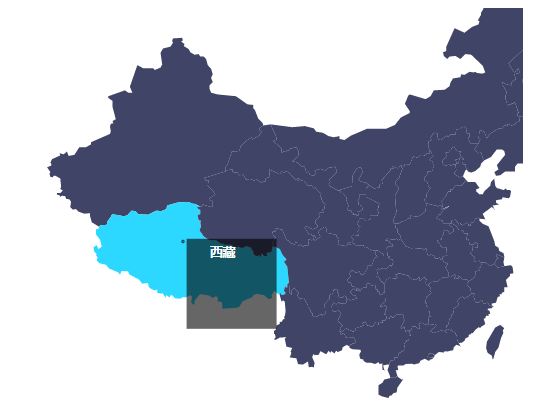
做鼠标文字跟随
想要有文字可以跟随鼠标移动,需要获取鼠标位置。为了方便使用,我们选用offsetX,offsetY,获取方法mouseXY()。
然后根据这两个位置绘制一个方框,里面填入相应的省份方法createFangkuang()。
还需要有三个事件:
- mouseover:鼠标移入,创建跟随方框
- mousemove:鼠标移动,删除上一个方框,根据新的鼠标位置创建新方框。
- mouseout:鼠标移除,删除方框
代码:
.fangkuang{
			width: 100px;
			height: 100px;
			padding: 5px;

			opacity: 0.6;
			border:1px solid #fff;
			border-radius: 5px;

		}

		.......

        //返回当前鼠标位置
		function mouseXY(e){
			var e=e||window.event;
			return { "x": e.offsetX, "y": e.offsetY };
		}

		//移除方框
		function fangkuangRemove()
		{
			d3.select("#fangkuang1").remove();
			d3.select("#fangkuang2").remove();
		}
		//创建方框和文字
		function createFangkuang(svg,d)
		{

			let XY=mouseXY(event);
			svg.append("rect")
			        .attr("id", "fangkuang1")
			        .attr("x", XY.x)
			        .attr("y",XY.y)
					.attr("class","fangkuang")
		//创建显示tooltip文本
		svg.append("text")
			        .attr("id", "fangkuang2")
			        .attr("x", XY.x+40)
			        .attr("y",XY.y+20)
			        .attr("text-anchor", "middle")
			        .attr("font-family", "sans-serif")
			        .attr("font-size", "14px")
			        .attr("font-weight", "bold")
			        .attr("fill", "#fff")
			        .text(d.properties.name);
		}
	......

	groups.selectAll("path")
			.data(root.features) // 绑定数据
			.enter()
			.append("path")
			.on('mouseover',function(d,i){
				d3.select(this)
				.style('fill','#2CD8FF');
				console.log('ss');
				createFangkuang(svg,d);
			})
			.on('mousemove',function(d,i){
				fangkuangRemove();
				createFangkuang(svg,d);
			})
			.on('mouseout',function(d,i){
				d3.select(this)
				.style('fill', '#404466');
				fangkuangRemove();
			})
			.style("fill",'#404466')//填充内部颜色
			.attr("d",path)//使用路径生成器
效果:

产生方框不停闪动的问题及解决办法
在查看效果时那个跟随方框不停闪动,效果很不好。根据观察和测试,发现它不断的触发mouseover事件,然而按照逻辑应该是将鼠标放在一个新的省份时才会触发它。
思考了一下事件冒泡的可能性:
- 可是这里没有出现父子级都有相同事件的情况,所以这种情况排除。
- 又想会不会是在移动的过程中鼠标指向的元素可能不是
,而变成了它的父节点svg或是移动到了rect,text内,导致鼠标暂时离开path,造成不断触发了mouseover,mouseout事件。经过检查,发现确实是这样,在向方框的方向移到是,鼠标移到了rect,text内,造成闪动。
解决方法:
- 将offsetX改为clientX,这样不会产生闪动的问题,但是clientX是鼠标到浏览器窗口的左上角,要想鼠标跟随,需要计算,这样不方便。
- 将方框放到离鼠标有一段距离的地方,保持距离,让鼠标在移动时不会移动到方框内。
- 有一个css样式:pointer-events:none;元素不再是鼠标事件的目标,鼠标不再监听当前层而去监听下面的层中的元素。
看情况可作出适当选择。
代码
<!DOCTYPE html>
<html>
	<head>
		<meta charset="utf-8">
		<title>中国地图</title>
		<script src="http://d3js.org/d3.v3.min.js"></script>
	</head>
	<style>
		.fangkuang{
			width: 100px;
			height: 100px;
			padding: 5px;

			opacity: 0.6;
			border:1px solid #fff;
			border-radius: 5px;

		}
		#fangkuang1{
			pointer-events: none;
		}
		#fangkuang2{
			pointer-events: none;
		}

	</style>
	<body>
		<svg></svg>
	</body>
	<script>

		var width = 960, height = 700;
		//1.定义投影和生成器
		//定义地图投影
		var projection=d3.geo.mercator()
		.center([107,31]) //地图中心位置,107是经度,31是纬度
		.scale(600) //设置缩放量
		.translate([width/2,height/2]); // 设置平移量

		//定义地理路径生成器,使每一个坐标都会先调用此投影,才产生路径值
		var path=d3.geo.path()
		.projection(projection);// 设定投影

		//3.请求china.geo.json数据,添加<path>,每个path用于绘制一个省的路径
		/**
		 * 获取鼠标位置
		 * @param {Object} e 当前的元素对象
		 */
		function mouseXY(e){
			var e=e||window.event;
			return { "x": e.offsetX, "y": e.offsetY };
		}

		/**
		 * 删除文字和方框
		 */
		function fangkuangRemove()
		{
			d3.select("#fangkuang1").remove();
			d3.select("#fangkuang2").remove();
		}
		/**
		 * 创建方框和框内文字
		 * @param {Object} svg
		 * @param {Object} d
		 */
		function createFangkuang(svg,d)
		{

			let XY=mouseXY(event);
			svg.append("rect")
			        .attr("id", "fangkuang1")
			        .attr("x", XY.x)
			        .attr("y",XY.y)
					.attr("class","fangkuang")
			//创建显示tooltip文本
			svg.append("text")
			        .attr("id", "fangkuang2")
			        .attr("x", XY.x+40)
			        .attr("y",XY.y+20)
			        .attr("text-anchor", "middle")
			        .attr("font-family", "sans-serif")
			        .attr("font-size", "14px")
			        .attr("font-weight", "bold")
			        .attr("fill", "#fff")
			        .text(d.properties.name);
		}
		//请求china.geo.json
		d3.json("http://localhost/china.geo.json",function(err,root){
			if(err){
				alert('数据请求失败');
			}
			console.log(root);
			//创建svg
			var svg = d3.select("body")
			        .append("svg")
			        .attr("width", width)
			        .attr("height", height);

			var groups=svg.append("g");

			groups.selectAll("path")
			.data(root.features) // 绑定数据
			.enter()
			.append("path")
			.on('mouseover',function(d,i){
				d3.select(this)
				.style('fill','#2CD8FF');
				console.log('ss');
				createFangkuang(svg,d);
			})
			.on('mousemove',function(d,i){
				fangkuangRemove();
				createFangkuang(svg,d);
			})
			.on('mouseout',function(d,i){
				d3.select(this)
				.style('fill', '#404466');
				fangkuangRemove();
			})
			.style("fill",'#404466')//填充内部颜色
			.attr("d",path)//使用路径生成器

		})
	</script>
</html>

附录
chain.geo.json:
https://github.com/ELLENXX/d3-GeoJSON-.git

