


Three Standard Geocoding Methods
refer to : http://www.directionsmag.com/article.php?article_id=670&trv=1&trv=1
In order to geocode data, it must contain information about location such as a street address, a postal code (or at least part of it), or a name of an area, e.g.county, census subdivision, etc.Geocoding is about adding x, y coordinates to point locations represented by these pieces of information.Three main methods of geocoding are available:
- by street address,
- by postal code; and
- by boundary.
Geocoding is performed using a reference layer.In Canada, the reference layers could be a street network file, a Postal Code Conversion File (PCCF), a Forward Sortation Area (FSA) file or any other boundary file.These layers can be purchased from Statistics Canada or other data providers.These same types of reference files are available for many other countries as well.Various ways of geocoding pinpoint records on a map with different levels of accuracy.The most accurate of these three methods is geocoding based on a street address.
Geocoding by street address
Address geocoding
involves matching addresses in a table to be geocoded to the street
names and address ranges in the street network file.Geocoding software
reads the first record in the file.It first matches the street name in
both - table to be geocoded and a reference table, which is accompanied
by a map.Once the street name is matched, all address ranges for this
street are examined in order to determine the street segment where the
particular address is found, on the odd or even number side of the
street.This part of the geocoding process is known as address
matching.Since the coordinates of the street segment endpoints are in
the reference layer, as well as the range of street numbers for this
segment, it is possible for the software to interpolate the coordinates
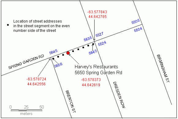
of the address.In the example below the table to be geocoded (Table 1)
consists of a few restaurants and their addresses.Table 2 is an example
of a reference attribute table, with the fields specific to a
particular address style (U.S.streets in this case).The address of the
Harvey's Restaurants (marked with a red arrow) is found in the second
record in the reference table, on the even number side of the street
(FromLeft, ToLeft).Interpolated addresses are distributed evenly along
a street segment as illustrated in Figure 1.The 5650 Spring Garden Rd
address is the sixth point from east (symbolized on a map with a red
dot).Most likely it is not a true location of this restaurant.Street
address geocoding produces only an approximation of this restaurant's
true location.
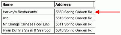
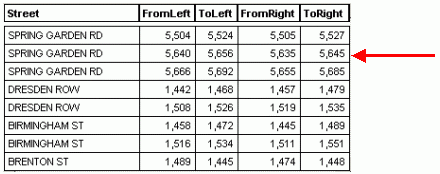
Table 2.Sample records from the attribute table for a reference layer.
Address geocoding results in the same accuracy in urban and rural
areas, as illustrated in Figures 2 and 3.In rural areas in Canada,
however, address geocoding cannot often be completed, because address
ranges are not available for small towns and other small
communities.This is improving every year, as street network data
providers release new versions of street network files.
