[1079] QGIS tools to python code
Steps:
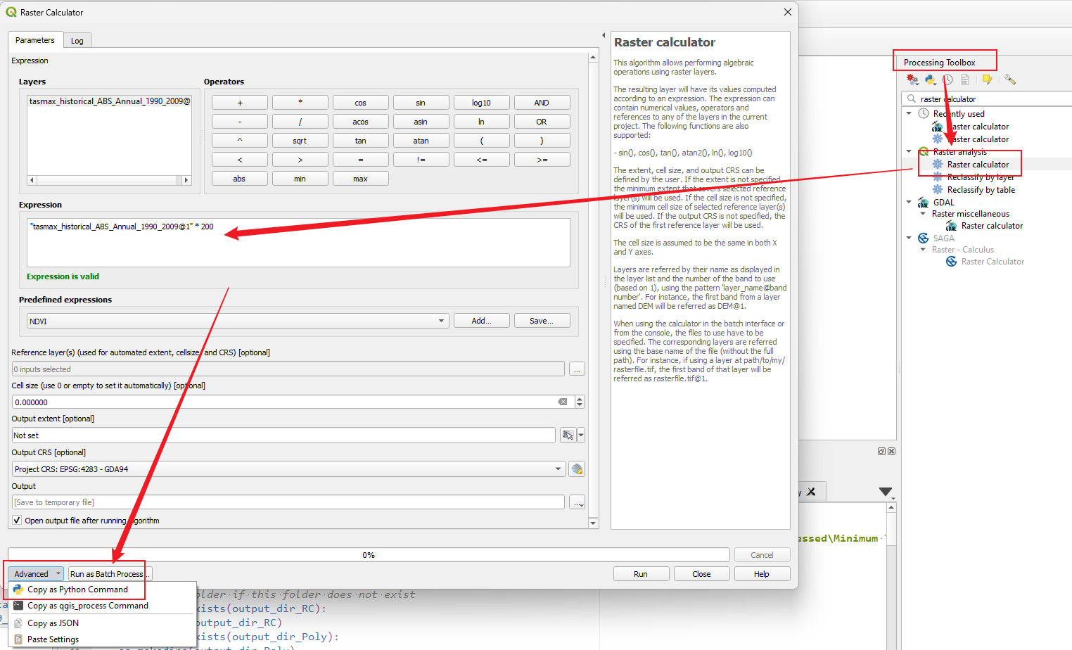
- Open the
Processing Toolboxin QGIS. - Search for the desired tool, such as the
Raster Calculator. - Set the parameters for the selected tool according to your requirments.
- Click on
Advanced, and convert the tool to Python code.

Examples: Raster Calculator -> Polygonize
The following script needs to be executed using QGIS's built-in Python interpreter.
import os, math

input_dir = r"..\Data_to_be_processed\Minimum Temperature\Projections\SSP3_7.0\Absolute"
output_dir_RC = os.path.join(input_dir, "RasterCalculator")
output_dir_Poly = os.path.join(input_dir, "Polygonize")

# create a new folder if this folder does not exist
if not os.path.exists(output_dir_RC):
    os.makedirs(output_dir_RC)
if not os.path.exists(output_dir_Poly):
    os.makedirs(output_dir_Poly)

def raster_calculator_func(input_fp, output_fp, operator, weight_number):
    file_name = os.path.basename(input_fp).split('.')[0]
    processing.run(
        "qgis:rastercalculator",
        {
            'EXPRESSION':f' ( "{file_name}@1" - {weight_number / 2} ) {operator} {weight_number}', # replace the file name, operator and weight number
            'LAYERS':[input_fp], # input file path
            'CELLSIZE':0,
            'EXTENT':None,
            'CRS':QgsCoordinateReferenceSystem('EPSG:4283'),
            'OUTPUT':output_fp})

def polygonize_func(input_fp, output_fp):
    processing.run(
        "gdal:polygonize",
        {
            'INPUT':input_fp,
            'BAND':1,
            'FIELD':'DN',
            'EIGHT_CONNECTEDNESS':False,
            'EXTRA':'',
            'OUTPUT':output_fp})

for fn in os.listdir(input_dir):
    if fn.endswith(".tif"):
        input_fp = os.path.join(input_dir, fn)
        output_fp_RC = os.path.join(output_dir_RC, fn)

        raster_calculator_func(input_fp, output_fp_RC, '/', 3)

        output_fp_Poly = os.path.join(output_dir_Poly, fn.replace("tif", "shp"))

        polygonize_func(output_fp_RC, output_fp_Poly)

        print("Complete the raster calculator of", fn)
        print()

