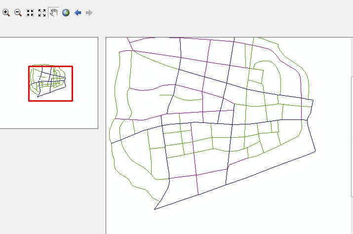
鹰眼的实现
分析:主图更新地图或改变显示范围,鸟瞰图随之发生变化;点击鸟瞰图,主图移动到相应的范围进行显示;鸟瞰图上面有一个红色的框。
实现思路:
1.要添加两个MapControl控件,其中axMapControl1为主图,而axMapControl2为鸟瞰图。
2.axMapControl1的MapControl控件,OnExtentUpdated,OnMapReplaced
3. axMapControl2的MapControl控件,OnMouseDown

        private void axMapControl1_OnExtentUpdated(object sender, ESRI.ArcGIS.Controls.IMapControlEvents2_OnExtentUpdatedEvent e)
        {
            //先获取新的范围
            IEnvelope pEnvelope = e.newEnvelope as IEnvelope;
            //clear map2's contents
            IGraphicsContainer pContainter = axMapControl2.ActiveView.GraphicsContainer;
            pContainter.DeleteAllElements();
            //绘制一个矩形框
            IRectangleElement rect = new RectangleElement() as IRectangleElement;
            IElement pElement = rect as IElement;
            pElement.Geometry = pEnvelope;

            //
            IRgbColor color = new RgbColor() as IRgbColor;
            color.Red = 255;
            color.Green = 0;
            color.Blue = 0;
            color.Transparency = 255;
            //
            ILineSymbol line = new SimpleLineSymbol() as ILineSymbol;
            line.Width = 2;
            line.Color = color;
            //
            color.Transparency = 0;
            //
            IFillSymbol fill = new SimpleFillSymbol();
            fill.Color = color;
            fill.Outline = line;
            //
            IFillShapeElement shapeElement = pElement as IFillShapeElement;
            shapeElement.Symbol = fill;
            //
            pContainter.AddElement(shapeElement as IElement,0);
            axMapControl2.ActiveView.Refresh();

        }

        private void Form1_Load(object sender, EventArgs e)
        {
            axMapControl1.ClearLayers();
            axMapControl1.ActiveView.Refresh();
            OpenFileDialog open = new OpenFileDialog();
            string filename = string.Empty;
            if (open.ShowDialog() == DialogResult.OK)
            {
                filename = open.FileName;
            }
            axMapControl1.LoadMxFile(filename);
            //axMapControl2.LoadMxFile(filename);
            axMapControl1.ActiveView.Refresh();
           // axMapControl2.ActiveView.Refresh();
        }

        private void axMapControl1_OnMapReplaced(object sender, ESRI.ArcGIS.Controls.IMapControlEvents2_OnMapReplacedEvent e)
        {
            for (int i = 0; i < axMapControl1.Map.LayerCount - 1; i++)
            {
                axMapControl2.AddLayer(axMapControl1.get_Layer(i));
            }
            axMapControl2.Extent = axMapControl1.Extent;
            axMapControl2.Refresh();
        }

        private void axMapControl2_OnMouseDown(object sender, ESRI.ArcGIS.Controls.IMapControlEvents2_OnMouseDownEvent e)
        {
            if (e.button == 1)
            {
                IPoint point = new ESRI.ArcGIS.Geometry.Point();
                point.X = e.mapX;
                point.Y = e.mapY;

                axMapControl1.CenterAt(point);
                axMapControl1.ActiveView.Refresh();
            }
        }


