Cesium模型贴地问题(八)
2023-01-12
1.sampleTerrainMostDetailed
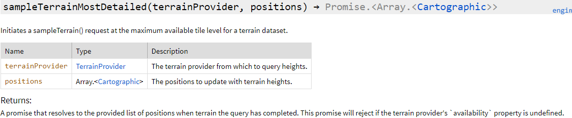
根据提供的terrainPrivider和点的弧度坐标计算出当前点的高度信息。
      var p = new Cesium.Cartographic.fromCartesian(new Cesium.Cartesian3.fromDegrees(103.8603, 30.704));
      let promise = Cesium.sampleTerrainMostDetailed(this.viewer.terrainProvider, [p])
      Promise.resolve(promise).then(function(updatedPositions) {
        console.log(`updatedPositions为:${updatedPositions}`);
      });
updatePositions为:(1.8127041971090665, 0.535885893532339, 495.32088938674565)
获得了高度就可以去调整模型的位置了
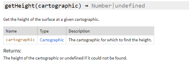
在Globe里还有geiHeight方法获得高度
2.heightReference属性
      var entity6 = this.viewer.entities.add({
        id:6,
        position:new Cesium.Cartesian3.fromDegrees(103.8603, 30.704,0),
        //设置朝向和翻滚角度
        orientation:orientation,
        model:{
          uri:"../../../static/3DModel/higokumaru__honkai_impact_3rd/scene.gltf",
          show:true,
          scale: 5.0 ,
          silhouetteColor : Cesium.Color.YELLOW,
          silhouetteSize : 0,
          colorBlendMode:Cesium.ColorBlendMode.MIX,
          colorBlendAmount: 0,
          heightReference: Cesium.HeightReference.CLAMP_TO_GROUND
        }
      })
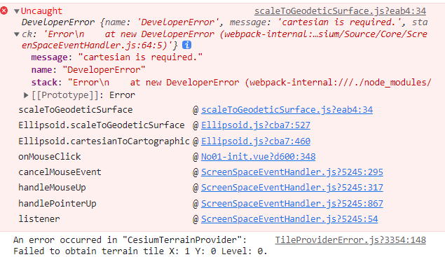
这样的前提是需要地形先加载好,不然的话模型会出现在地心
这种情况就是模型加载好了地形没加载好,找不到椭球就没法计算高度
3.3dtile矩阵变换
    var tileset = new Cesium.Cesium3DTileset({
      url: "../../../static/3DModel/sicauOSM/tileset.json",
    });
    this.viewer.scene.primitives.add(tileset);
    console.log(tileset);

    //3dtile加载完成后执行,进行位置变化
    tileset.readyPromise.then(function(tileset) {

    //高度偏差,向上是正数,向下是负数
    var heightOffset = 500.0;

    //计算tileset的绑定范围
    var boundingSphere = tileset.boundingSphere;

    //计算中心点位置
    /**
     * fromCartesian 方法是用经纬度和高度定义一个位置
     * A position defined by longitude, latitude, and height.
     */
    var cartographic = Cesium.Cartographic.fromCartesian(boundingSphere.center);

    //计算中心点位置的地表坐标
    /**
     * Cartesian3 是一个3D点 笛卡尔坐标
     * Cartesian2 是屏幕坐标
     * cartographic 是椭球坐标
     * fromRadians 方法 Returns a Cartesian3 position from longitude and latitude values given in radians(弧度).
     * @param longitude
     * @param latitude
     * @param height
     * 因为建筑模型没他所在高度信息,所以填0
     */
    var surface = Cesium.Cartesian3.fromRadians(cartographic.longitude, cartographic.latitude, 0.0);

    //偏移后的坐标,也就是中心点本应在的高度(海拔)
    var offset = Cesium.Cartesian3.fromRadians(cartographic.longitude, cartographic.latitude, heightOffset);

    /**
     * subtract 方法 Computes the componentwise difference of two Cartesians.
     * 计算两个笛卡尔坐标的成分差异
     * @param 就是两个要计算的坐标
     * @param 第三个参数是要保存的结果
     */
    var translation = Cesium.Cartesian3.subtract(offset, surface, new Cesium.Cartesian3());

    //tileset.modelMatrix转换
    /**
     * Creates a Matrix4 instance from a Cartesian3 representing the translation.
     * @param {Cartesian3} translation - The upper right portion of the matrix representing the translation.
     * @param {    Matrix4} result - The object in which the result will be stored, if undefined a new instance will be created.
     * Cesium中使用Matrix4作为处理线性变换和位移变换的仿射矩阵
     * 三维空间的转换矩阵通常是3x3的就可以
     * 但是为了同时满足位移的需要增加了一个维度使用4x4的矩阵
     */
    tileset.modelMatrix = Cesium.Matrix4.fromTranslation(translation);


    /**
     * 定位到3dtiles的位置,也就是让摄像头对准这个区域
     * viewBoundingSphere 方法
     * Sets the camera so that the current view contains the provided bounding sphere.
     * @param boundingSphere - The bounding sphere to view, in world coordinates.
     * @param offset  - The offset from the target in the local east-north-up reference frame centered at the target.
     */
    this.viewer.camera.viewBoundingSphere(tileset.boundingSphere, new Cesium.HeadingPitchRange(0, -20, 0));

    });
cesium中经常用到矩阵变换,基础要打好