Redis实现附近的人/物/地点
一、 实现方式
- MySQL + 外接正方形
- MySQL + Geohash
- Redis + Geohash
二、 具体实现
MySQL + 外接正方形
实现思路
查找附近500米的人,就是以当前坐标点为圆心,以500米为半径画圆,找出圆内的人。
理论上可以直接计算数据库所有点与圆心的距离,与500米比较。但计算地球上两点距离公式复杂,一旦数据库数据过多,计算起来就更麻烦了。
我们可以通过外接正方形的方式来解决这个问题。这样一来,计算量骤减。[注:设定下图圆心在北半球,东半球]
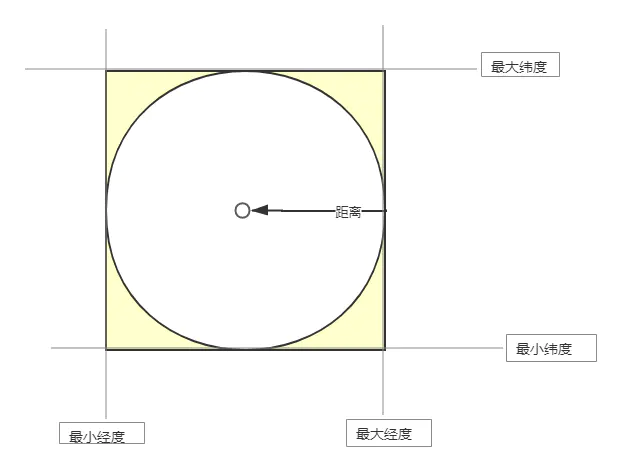
实现步骤
- 计算外切正方形最大最小经纬度
- 查询在正方形范围内的数据
- 过滤得到圆周内的点,即用正方形范围内的点-黄色区域的点(距离超过给定范围500米)
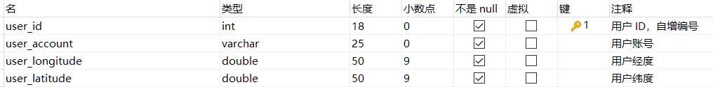
数据库表结构
代码实现
获取外切正方形最大最小经纬度有两种方法,可以自己实现,也可用开源库实现。
1. 自己实现getGpsRange方法
此方法用到了半矢量公式,以下计算推导过程可参考根据给定点的经纬度和特定距离取范围类的数据
/**
 * 获取附近x米的人
 *
 * @param distance 距离范围 单位km
 * @param userLng  当前经度
 * @param userLat  当前纬度
 * @return
 */
public List<User> nearBySearch1(double distance, double userLng, double userLat) {
    //1 获取外切正方形最大最小经纬度
    double[] point = getGpsRange(userLng, userLat, distance);
    //2 获取位置在正方形内的所有用户
    // 查询数据库操作,这里用mybatis plus实现
    List<User> users = list(Wrappers.<User>lambdaQuery().ge(User::getUserLongitude, point[0]).lt(User::getUserLongitude, point[1]).ge(User::getUserLatitude, point[2]).lt(User::getUserLatitude, point[3]));
    //3 过滤掉超过指定距离的用户
    users = users.stream().filter(a -> getDistance(a.getUserLongitude(), a.getUserLatitude(), userLng, userLat) <= distance)
            .collect(Collectors.toList());
    return users;
}

/**
 * 查询出某个范围内的最大经纬度和最小经纬度
 * 自己计算
 *
 * @param longitude 当前位置经度
 * @param latitude  当前位置纬度
 * @param rangeDis  距离范围,单位km
 * @return
 */
public static double[] getGpsRange(double longitude, double latitude, double rangeDis) {
    //半矢量公式,与圆心在同纬度上,且在圆周上的点到圆点的经度差
    double dlng = 2 * Math.asin(Math.sin(rangeDis / (2 * EARTH_RADIUS)) / Math.cos(latitude * Math.PI / 180));
    //弧度转为角度
    dlng = dlng * 180 / Math.PI;

    //半矢量公式,与圆心在同经度上,且在圆周上的点到圆点的纬度差
    //弧度转为角度
    double dlat = rangeDis / EARTH_RADIUS;
    dlat = dlat * 180 / Math.PI;

    double minlng = longitude - dlng;
    double maxlng = longitude + dlng;
    double minlat = latitude - dlat;
    double maxlat = latitude + dlat;
    return new double[]{minlng, maxlng, minlat, maxlat};
}

/**
 * 根据地球上任意两点的经纬度计算两点间的距离(半矢量公式),返回距离单位:km
 *
 * @param longitude1 坐标1 经度
 * @param latitude1  坐标1 纬度
 * @param longitude2 坐标2 经度
 * @param latitude2  坐标2 纬度
 * @return 返回km
 */
public static double getDistance(double longitude1, double latitude1, double longitude2, double latitude2) {
    double radLat1 = Math.toDegrees(latitude1);
    double radLat2 = Math.toDegrees(latitude2);
    double a = radLat1 - radLat2;
    double b = Math.toDegrees(longitude1) - Math.toDegrees(longitude2);
    double distance = 2 * Math.asin(Math.sqrt(Math.pow(Math.sin(a / 2), 2) +
            Math.cos(radLat1) * Math.cos(radLat2) * Math.pow(Math.sin(b / 2), 2)));
    distance = distance * EARTH_RADIUS;
    distance = Math.round(distance * 10000) / 10000.0;
    return distance;
}
2. 开源库计算外接正方形坐标范围
<dependency>
    <groupId>com.spatial4j</groupId>
    <artifactId>spatial4j</artifactId>
    <version>0.5</version>
</dependency>
private SpatialContext spatialContext = SpatialContext.GEO;

/**
 * 获取附近x米的人
 *
 * @param distance 距离范围 单位km
 * @param userLng  当前经度
 * @param userLat  当前纬度
 * @return
 */
public List<User> nearBySearch(double distance, double userLng, double userLat) {
    //1 获取外切正方形最大最小经纬度
    Rectangle rectangle = getRectangle(distance, userLng, userLat);
    //2.获取位置在正方形内的所有用户
    // 查询数据库操作,这里用mybatis plus实现
    List<User> users = list(Wrappers.<User>lambdaQuery().ge(User::getUserLongitude, rectangle.getMinX()).lt(User::getUserLongitude, rectangle.getMaxX()).ge(User::getUserLatitude, rectangle.getMinY()).lt(User::getUserLatitude, rectangle.getMaxY()));
    //3.剔除半径超过指定距离的多余用户
    users = users.stream().filter(a -> getDistance(a.getUserLongitude(), a.getUserLatitude(), userLng, userLat) <= distance)
            .collect(Collectors.toList());
    return users;
}

/**
 * 利用开源库计算外接正方形坐标
 *
 * @param distance
 * @param userLng  当前经度
 * @param userLat  当前纬度
 * @return
 */
private Rectangle getRectangle(double distance, double userLng, double userLat) {
    return spatialContext.getDistCalc()
            .calcBoxByDistFromPt(spatialContext.makePoint(userLng, userLat),
                    distance * DistanceUtils.KM_TO_DEG, spatialContext, null);
}

/***
 * 球面中,两点间的距离(第三方库方法)
 *
 * @param longitude 经度1
 * @param latitude  纬度1
 * @param userLng   经度2
 * @param userLat   纬度2
 * @return 返回距离,单位km
 */
public double getDistance(Double longitude, Double latitude, double userLng, double userLat) {
    return spatialContext.calcDistance(spatialContext.makePoint(userLng, userLat),
            spatialContext.makePoint(longitude, latitude)) * DistanceUtils.DEG_TO_KM;
}
Geohash算法
在介绍后面两种方法之前,我们先来了解下Geohash算法。
Geohash算法思想
将地球球面沿着180°经线分开,平铺到平面上。
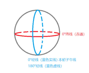
0°经线和0°纬线将此平面划分为四部分。设定西经为负,南纬为负,地球上的经度范围就是[-180°,180°],纬度范围就是[-90°,90°]。
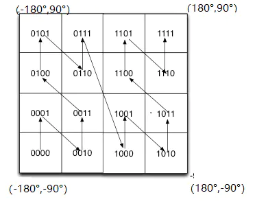
如果纬度范围[-90°, 0°)用二进制0代表,(0°, 90°]用二进制1代表,经度范围[-180°, 0°)用二进制0代表,(0°, 180°]用二进制1代表,那么划分出的四部分用二进制表示为:

Geohash算法就是基于这种思想,不断递归对半划分,划分的次数越多,区域越多,区域面积越小。
Geohash算法编码经纬度
1. 将经纬度变成二进制
以点(118.818747,32.074497)为例。
纬度的范围是(-90,90),以其中间值0将此范围划分为两个区间(-90,0)和(0,90),若给定的纬度在左区间(-90,0),则为0;若给定的纬度在右区间(0,90),则为1;纬度32.074497在右区间,因此为1。
再将(0,90)这个区间以中间值划分为左右区间,按照以上方法判定为1还是0。
依此方法,可得到纬度的二进制表示,如下表:
| 纬度范围 | 划分的左区间 | 划分的右区间 | 纬度32.074497的二进制表示 |
|---|---|---|---|
| (-90,90) | (-90,0) | (0,90) | 1 |
| (0,90) | (0,45) | (45,90) | 0 |
| (0,45) | (0,22.5) | (22.5,45) | 1 |
| (22.5,45) | (22.5,33.75) | (33.75,45) | 0 |
| (22.5,33.75) | (22.5,28.125) | (28.125,33.75) | 1 |
| …… | …… | …… | …… |
划分10次后,得到的纬度二进制表示为10101 10110
同样的方法,可得到划分9次后经度二进制表示为110101
2. 将经纬度合并
合并方法:经度占偶数位,纬度占奇数位
经纬度合并结果为 11100 11001 11000 10110
3. 按照Base32进行编码
将2的结果用Base32编码得到字符串wtsq。也就是说点(118.818747,32.074497)可用wtsq表示。
Geohash扩展
-
GeoHash字符串越长,表示的位置越精确,字符串长度越长代表在距离上的误差越小。
具体的不同精度的距离误差可参考下表:
-
GeoHash值表示的并不是一个点,而是一个矩形区域。
-
Geohash比直接用经纬度的高效很多,而且使用者可以发布地址编码,既能表明自己所在区域,又不至于暴露自己的精确坐标,有助于隐私保护。
-
距离越近的坐标,转换后的Geohash字符串越相似,例如:

MySQL + Geohash
实现思路
- 添加新用户时计算该用户的Geohash字符串,并存储到用户表中。
- 当要查询某个点附近指定距离的用户信息时,通过比对Geohash误差表确定需要的Geohash字符串精度。
- 计算获得当前坐标的Geohash字符串,并查询与当前字符串前缀相同的数据。
- 如果Geohash字符串的精度远大于给定的距离范围时,查询出的结果集中必然存在在范围之外的数据。
- 计算两点之间距离,对于超出距离的数据进行剔除。
数据库表结构

代码实现
<dependency>
    <groupId>com.spatial4j</groupId>
    <artifactId>spatial4j</artifactId>
    <version>0.5</version>
</dependency>
private SpatialContext spatialContext = SpatialContext.GEO;

    /**
 * 获取附近指定范围的人
 *
 * @param distance 距离范围 单位km
 * @param len      geoHash的精度
 * @param userLng  当前用户的经度
 * @param userLat  当前用户的纬度
 * @return
 */
public List<User> nearBySearch2(double distance, int len, double userLng, double userLat) {
    //1.根据要求的范围,确定geoHash码的精度,获取到当前用户坐标的geoHash码
    String geoHashCode = GeohashUtils.encodeLatLon(userLat, userLng, len);
    //2.匹配指定精度的geoHash码
    //查询数据库操作 mybatis plus实现
    List<User> users = list(Wrappers.<User>lambdaQuery().likeRight(User::getGeohash, geoHashCode));
    //3.过滤超出距离的
    users = users.stream()
            .filter(a -> getDistance1(a.getUserLongitude(), a.getUserLatitude(), userLng, userLat) <= distance)
            .collect(Collectors.toList());
    return users;
}

/***
 * 球面中,两点间的距离(第三方库方法)
 *
 * @param longitude 经度1
 * @param latitude  纬度1
 * @param userLng   经度2
 * @param userLat   纬度2
 * @return 返回距离,单位km
 */
public double getDistance(Double longitude, Double latitude, double userLng, double userLat) {
    return spatialContext.calcDistance(spatialContext.makePoint(userLng, userLat),
            spatialContext.makePoint(longitude, latitude)) * DistanceUtils.DEG_TO_KM;
}

/**
 * 向数据库添加数据
 *
 * @param user 用户对象
 * @return
 */
public boolean save(User user) {
    //默认精度12位
    String geoHashCode = GeohashUtils.encodeLatLon(user.getUserLatitude(), user.getUserLongitude());
    //插入数据库操作 mybatis plus实现
    super.save(user.setGeohash(geoHashCode));
}
边界问题优化
Geohash算法提高了效率,但在实际应用场景中存在一些问题。首先就是边界问题。
如图,如果当前在红点位置,区域内还有一个黄点。相邻区域内的绿点明显离红点更近。但因为黄点的编码和红点一样,最终找到的将是黄点。
要解决这个问题,除了要找到当前区域内的点,还要要再查找周边8个区域内的点,看哪个离自己更近。
这里提供了求解当前区域周围8个区域的思路:Geohash求当前区域周围8个区域编码的一种思路
由此优化代码为:
<dependency>
    <groupId>com.spatial4j</groupId>
    <artifactId>spatial4j</artifactId>
    <version>0.5</version>
</dependency>

<dependency>
    <groupId>ch.hsr</groupId>
    <artifactId>geohash</artifactId>
    <version>1.0.10</version>
</dependency>
private SpatialContext spatialContext = SpatialContext.GEO;

/**
 * 获取附近x米的人,geohash区域+8个周围区域
 *
 * @param distance 距离范围 单位km
 * @param len      geoHash的精度
 * @param userLng  当前经度
 * @param userLat  当前纬度
 * @return json
 */
public List<User> nearBySearch4(double distance, int len, double userLng, double userLat) {

    //1 根据要求的范围,确定geoHash码的精度,获取到当前用户坐标的geoHash码
    GeoHash geoHash = GeoHash.withCharacterPrecision(userLat, userLng, len);
    //2 获取到用户周边8个方位的geoHash码
    GeoHash[] adjacent = geoHash.getAdjacent();
    //查询数据库操作 mybatis plus实现
    QueryWrapper<User> queryWrapper = new QueryWrapper<User>().likeRight("user_geohash", geoHash.toBase32());
    Stream.of(adjacent).forEach(a -> queryWrapper.or().likeRight("user_geohash", a.toBase32()));
    //匹配指定精度的geoHash码
    List<User> users = list(queryWrapper);
    //3 过滤超出距离的
    users = users.stream()
            .filter(a -> getDistance(a.getUserLongitude(), a.getUserLatitude(), userLng, userLat) <= distance)
            .collect(Collectors.toList());
    return users;
}

/***
 * 球面中,两点间的距离(第三方库方法)
 *
 * @param longitude 经度1
 * @param latitude  纬度1
 * @param userLng   经度2
 * @param userLat   纬度2
 * @return 返回距离,单位km
 */
public double getDistance(Double longitude, Double latitude, double userLng, double userLat) {
    return spatialContext.calcDistance(spatialContext.makePoint(userLng, userLat),
            spatialContext.makePoint(longitude, latitude)) * DistanceUtils.DEG_TO_KM;
}
Redis + Geohash
基于前两种方案,我们可以发现此功能属于读多写少的情况,如果使用Redis来实现附近的人,想必效率会大大提高。
自Redis 3.2开始,Redis基于Geohash和有序集合Zset提供了地理位置相关功能。
关于Redis提供的geohash操作命令介绍可移步:Redis 到底是怎么实现“附近的人”这个功能的呢?
实现思路
- 用GEOADD方法添加用户坐标信息到redis,redis会将经纬度参数值转换为52位的Geohash码,
- Redis以Geohash码为score,将其他信息以Zset有序集合存入key中
- 通过调用GEORADIUS命令,获取指定坐标点某一范围内的数据
- 因Geohash存在精度误差,剔除超过指定距离的数据
代码实现
@Service
public class NearbyService {

    @Autowired
    private RedisTemplate redisTemplate;

    private static final String LOCATION_KEY = "LOCATION";

    /**
     * 新增定位点信息
     * @param name 定位点名称
     * @param longitude 经度坐标
     * @param latitude 维度坐标
     * @return
     */
    public boolean save(String name, double longitude, double latitude) {
        Long flag = redisTemplate.opsForGeo().add(LOCATION_KEY, new RedisGeoCommands.GeoLocation<>(
                name, new Point(longitude, latitude)));
        return flag != null && flag > 0;
    }

    /**
     * 移除定位点信息
     * @param name 定位点名称
     * @param longitude 经度坐标
     * @param latitude 维度坐标
     * @return
     */
    public boolean remove(String name, double longitude, double latitude) {
        Long flag = redisTemplate.opsForGeo().remove(LOCATION_KEY, new RedisGeoCommands.GeoLocation<>(
                name, new Point(longitude, latitude)));
        return flag != null && flag > 0;
    }

    /**
     * 检索获取附近信息
     * @param distance 距离
     * @param longitude 经度坐标
     * @param latitude 维度坐标
     * @return
     */
    public List<NearBy> nearbySearch(double distance, double longitude, double latitude) {
        // GEORADIUS获取附近范围内的信息
        GeoResults<RedisGeoCommands.GeoLocation<Object>> result =
                redisTemplate.opsForGeo().radius(LOCATION_KEY,
                        new Circle(new Point(longitude, latitude), new Distance(distance, Metrics.KILOMETERS)),
                        RedisGeoCommands.GeoRadiusCommandArgs.newGeoRadiusArgs()
                                .includeDistance()
                                .includeCoordinates()
                                .sortAscending());
        // 获取到的附近范围数据结果
        List<GeoResult<RedisGeoCommands.GeoLocation<Object>>> content = result.getContent();
        // 封装返回
        return content.stream().map(item ->
                new NearBy(item.getContent().getName().toString(), item.getDistance().getValue(),
                        item.getContent().getPoint().getX(), item.getContent().getPoint().getY())
        ).collect(Collectors.toList());
    }
}
总结
| 方案 | 优势 | 缺点 |
|---|---|---|
| MySQL + 外接正方形 | 逻辑清晰,实现简单,支持多条件筛选 | 效率较低,不适合大数据量,不支持按距离排序 |
| MySQL + Geohash | 借助索引有效提高效率,支持多条件筛选 | 不支持按距离排序,存在数据库瓶颈 |
| Redis + Geohash | 效率高,集成便捷,支持距离排序 | 不适合复杂对象存储,不支持多条件查询 |
