VNP14
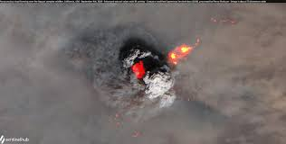 哪里火了喂?!
VNP14
以下关于VNP14"活跃火"产品的介绍,信息来源:https://lpdaac.usgs.gov/documents/427/VNP14_User_Guide_V1.pdf。
总体介绍
Land Science Investigator-led Processing System (SIPS),是NASA处理、生产和评估Suomi NPP-VIIRS陆地产品的系统。产品可能包括土地覆盖、雪覆盖、植被属性、水文属性、温度、反射率、反照率和火灾等。Land SIPS中集成所选产品的近实时算法,可在三小时内处理和交付这些产品,并通过NASA的Land Atmosphere Near real-time Capability for EOS(LANCE)系统分发。
VNP14基本上延续了EOS/MODIS活跃火产品制作的算法。
VNP14IMG (NASA Land-SIPS VIIRS 375 m 活跃火产品) 是基于I波段制作出来的(但是吧,这些波段当初设计的主要目标不是为了检测活跃火,而且吧,I4波段比较容易有像元饱和的问题),目前仍是一个试验(experimental) 。
饱和像素是指在图像或数字传感器中已达到可记录光强度的最大容量的像素。一旦一个像素达到饱和,它就无法准确地记录光强度的变化,并由传感器或相机分配一个固定的最大值。在红外传感器的情况下,饱和值通常是传感器的名义饱和温度,即传感器可以测量的最高温度。
VNP14IMG产品中的饱和像素通常有以下几种情况:1. 典型的像素饱和状态,这种像素被分配为名义饱和温度367 K。2. 当火灾信号大大超过通道I4的动态范围时,像素值将“折叠”并显示异常低的温度(🤔这是什么操作?反正用户手册里是这么写的)。不过这种情况,可以通过长波红外通道(I5)数据来协同验证。3. 是更具挑战性的情况:在机载数据聚合期间,达到饱和的本机像素与其他非饱和像素混合在一起,导致一级辐射信息受损。目前,在输入的一级数据中没有可用的质量标志来指示这些异常情况。
然后,用户手册中说:Nighttime detection. This is the period during which the VNP14IMG product is particularly responsive to heat sources thereby favoring plume detection. 夜间探测。这个时段,VNP14IMG产品对热源特别敏感,因此有利于烟团探测(烟羽检测)[感觉后面会用到,先标记一下⭐]。
产品架构
-
Level 2 (swath data, 幅宽数据),投影与输入L1数据类似,没有进行数据重采样或其他校正。
-
Level 3 (tiled data, 平铺数据集),使用预定的投影类型(如正弦投影)和固定像素大小(如500米)进行空间重采样和时间聚合(如8天数据堆栈)操作。
-
Level 4 (gridded data, 格网数据集),进行空间重采样从而获得符合气候模拟网格(CMG)产品(如0.25°×0.25°格网数据)。格网数据制作过程中会根据云遮蔽情况和采样频率(随纬度的不同发生变化)进行校正。
根据数据处理级别和处理环境,产品命名不同。目前的产品包括:VNP14 (Level 2), VNP14IMG (Level 2)和VNP14A1 (Level 3)活跃火灾数据集。
VNP14IMG 8位火灾掩膜数据集

欲知操作详情,请见Algorithm Theoretical Basis Document (ATBD)文件:https://viirsland.gsfc.nasa.gov/PDF/VIIRS_activefire_375m_ATBD.pdf
VNP14火灾掩膜数据


VNP14 ATBD文件:https://viirsland.gsfc.nasa.gov/PDF/VIIRS_activefire_750m_ATBD.pdf
中等分辨率传感器
AVHRR(Advanced Very High Resolution Radiometer)、MODIS(Moderate Resolution Imaging Spectroradiometer)和VIIRS(Visible Infrared Imaging Radiometer Suite)均是传感器,空间分辨率在百米级别。三个传感器首次搭载卫星分别在:AVHRR (1978年), MODIS (1999年), VIIRS (2011年);星下点空间分辨率分别约为1km, 250m/500m/1km, 375m/750m。
AVHRR
AVHRR (Advanced Very High Resolution Radiometer)传感器已经发展了三代:AVHRR/1只有4个原始波段(可见光+TIR);AVHRR/2在1的基础上增加1热红外波段(11.5μm-12.5μm);AVHRR/3在2的基础上增加1中红外波段(1.58μm-1.64μm),1998年首次搭载在NOAA-15上。
AVHRR的星下点分辨率为1.1km。由于扫描角大,图像边缘部分变形较大,实际上最有用的部分在±15°范围内(15°处地面分辨率为1.5km),这个范围的成象周期为6天。搭载在极轨环境卫星 (POES, polar orbiting Environmental Satellites) NOAA (National Oceanic and Atmospheric Administration)系列以及欧洲的MetOp卫星上。
基于该传感器数据制作的产品主要有:USGS制作的AVHRR NDVI composites和Global Land Cover Characterization(GLCC)[1]
首批1km全球土地覆被产品数据(IGBP-DISCover, UMD Land Cover classification)。
AVHRR波段信息[2]
| AVHRR/1 wavelength(μm) | AVHRR/2 wavelength(μm) | AVHRR/3 wavelength(μm) |
|---|---|---|
| 0.58 - 0.68 | 0.58 - 0.68 | 0.58 - 0.68 |
| 0.725 - 1.10 | 0.725 - 1.10 | 0.725 - 1.00 |
| 3.55 - 3.93 | 3.55 - 3.93 | 1.58 - 1.64 |
| 10.50 - 11.50 | 10.3 - 11.3 | 3.55 - 3.93 |
| 11.5 - 12.5 | 10.3 - 11.3 | |
| 11.5 - 12.5 |
| Band | Name | Spectral Range (μm) | Applications |
|---|---|---|---|
| Band 1 | Red | 0.58-0.68 | Urban, vegetation, snow/ice, daytime clouds |
| Band 2 | Near IR | 0.725-1.00 | Vegetation, land/water boundaries, snow/ice, flooding |
| Band 3A | Mid IR | 1.58-1.64 | Vegetation, snow/ice detection, dust monitoring |
| Band 3B | Thermal | 3.55-3.93 | Surface temperature, wildfire detection, nighttime clouds, volcanic eruptions |
| Band 4 | Thermal | 10.30-11.30 | Surface temperature, wildfire detection, nighttime clouds, volcanic eruptions |
| Band 5 | Thermal | 11.5-12.50 | Sea surface temperature, water vapor path radiance |
AVHRR搭载卫星一览表[3]
| Satellite name | Launch date | Service start | Service end |
|---|---|---|---|
| TIROS-N | 13 October 1978 | 19 October 1978 | 30 January 1980 |
| NOAA-6 | 27 June 1979 | 27 June 1979 | 16 November 1986 |
| NOAA-7 | 23 June 1981 | 24 August 1981 | 7 June 1986 |
| NOAA-8 | 28 March 1983 | 3 May 1983 | 31 October 1985 |
| NOAA-9 | 12 December 1984 | 25 February 1985 | 11 May 1994 |
| NOAA-10 | 17 September 1986 | 17 November 1986 | 17 September 1991 |
| NOAA-11 | 24 September 1988 | 8 November 1988 | 13 September 1994 |
| NOAA-12 | 13 May 1991 | 14 May 1991 | 15 December 1994 |
| NOAA-14 | 30 December 1994 | 30 December 1994 | 23 May 2007 |
| NOAA-15 | 13 May 1998 | 13 May 1998 | present |
| NOAA-16 | 21 September 2000 | 21 September 2000 | 9 June 2014 |
| NOAA-17 | 24 June 2002 | 24 June 2002 | 10 April 2013 |
| NOAA-18 | 20 May 2005 | 30 August 2005 | present |
| NOAA-19 | 6 February 2009 | 2 June 2009 | present |
| Metop-A | 19 October 2006 | 20 June 2007 | 15 November 2021 |
| Metop-B | 17 September 2012 | 24 April 2013 | present |
| Metop-C | 7 November 2018 | 3 July 2019 | present |
主要观测任务:
- 云盖(Cloud cover)
- 云光学深度(Cloud optical depth)
- 云顶高(Cloud top height)
- 云最高温度(Cloud top temperature)
- 云类型(Cloud type)
- 叶面积指数(LAI)
- 归一化差异植被指数(NDVI)
- 海面温度(Sea surface temperature)
- 海冰盖(Sea-ice cover)
次要观测任务:
- 气溶胶火山灰总柱(Aerosol volcanic ash Total Column)
- 生物质(Biomass)
- 云下降有效半径(Cloud drop effective radius)
- 云冰有效半径(Cloud ice effective radius)
- 综合水蒸气(IWV)
- 土地表面温度(Land surface temperature)
- 雪覆盖(Snow cover)
可能观测:
- 气溶胶火山灰(Aerosol volcanic ash)
- 地面的向下短波辐照度(Downward short-wave irradiance at Earth surface)
- 火分子盖(Fire fractional cover)
- 火辐射能力(Fire radiative power)
- 火温度(Fire temperature)
- 短波云反射(Short-wave cloud reflectance)
- 土壤水分(Soil moisture at surface)
- TOA的向上短波辐照(Upward short-wave irradiance at TOA)
- 风(水平)(Wind (horizontal))
MODIS
MODIS (Moderate Resolution Imaging Spectroradiometer)有20个Reflective Solar Bands (RSB, No. 1-19, 26),16个Thermal Emissive Bands (TEB, No.20-25, 27-36),共36个波段。1999年搭载在Terra上,2002年搭载在Aqua上。
MODIS的产品系列就不过多介绍了,详见MODIS Web (nasa.gov)。
MODIS波段信息[4]
| Band | Wavelength(μm) | Primary use | Resolution(m) |
|---|---|---|---|
| 1 | 0.620–0.670 | Land/cloud/aerosols boundaries | 250 |
| 2 | 0.841–0.876 | 250 | |
| 3 | 0.459–0.479 | Land/cloud/aerosols properties | 500 |
| 4 | 0.545–0.565 | 500 | |
| 5 | 1.230–1.250 | 500 | |
| 6 | 1.628–1.652 | 500 | |
| 7 | 2.105–2.155 | 500 | |
| 8 | 0.405–0.420 | Ocean color/phytoplankton/biogeochemistry | 1000 |
| 9 | 0.438–0.448 | 1000 | |
| 10 | 0.483–0.493 | 1000 | |
| 11 | 0.526–0.536 | 1000 | |
| 12 | 0.546–0.556 | 1000 | |
| 13 | 0.662–0.672 | 1000 | |
| 14 | 0.673–0.683 | 1000 | |
| 15 | 0.743–0.753 | 1000 | |
| 16 | 0.862–0.877 | 1000 | |
| 17 | 0.890–0.920 | Atmospheric water vapor | 1000 |
| 18 | 0.931–0.941 | 1000 | |
| 19 | 0.915–0.965 | 1000 | |
| 20 | 3.660–3.840 | Surface/cloud temperature | 1000 |
| 21 | 3.929–3.989 | 1000 | |
| 22 | 3.929–3.989 | 1000 | |
| 23 | 4.020–4.080 | 1000 | |
| 24 | 4.433–4.498 | Atmospheric temperature | 1000 |
| 25 | 4.482–4.549 | 1000 | |
| 26 | 1.360–1.390 | Cirrus clouds water vapor | 1000 |
| 27 | 6.535–6.895 | 1000 | |
| 28 | 7.175–7.475 | 1000 | |
| 29 | 8.400–8.700 | Cloud properties | 1000 |
| 30 | 9.580–9.880 | Ozone | 1000 |
| 31 | 10.780–11.280 | Surface/cloud temperature | 1000 |
| 32 | 11.770–12.270 | 1000 | |
| 33 | 13.185–13.485 | Cloud top altitude | 1000 |
| 34 | 13.485–13.785 | 1000 | |
| 35 | 13.785–14.085 | 1000 | |
| 36 | 14.085–14.385 | 1000 |
VIIRS
VIIRS (Visible Infrared Imaging Radiometer Suite)主要有两类波段:5个I波段(imaging bands,星下点空间分辨率375m)和16个M波段(moderate-resolution bands,星下点空间分辨率750m);外加一个DNB波段,总共22个波段。该传感器搭载在Suomi-NPP和NOAA-20上。
基于这个Suomi-NPP VIIRS的数据产品吧,我找了一个链接,LP DAAC - Search (usgs.gov)。
VIIRS波段信息[5]
| Band | Wavelength(μm) | Description | Resolution(m) |
|---|---|---|---|
| I1 | 0.6 - 0.68 | Visible/Reflective | 375 |
| I2 | 0.85 - 0.88 | Near Infrared | 375 |
| I3 | 1.58 - 1.64 | Shortwave Infrared | 375 |
| I4 | 3.55 - 3.93 | Medium-wave Infrared | 375 |
| I5 | 10.5 - 12.4 | Longwave Infrared | 375 |
| M1 | 0.402 - 0.422 | Visible/Reflective | 750 |
| M2 | 0.436 - 0.454 | Visible/Reflective | 750 |
| M3 | 0.478 - 0.488 | Visible/Reflective | 750 |
| M4 | 0.545 - 0.565 | Visible/Reflective | 750 |
| M5 | 0.662 - 0.682 | Near Infrared | 750 |
| M6 | 0.739 - 0.754 | Near Infrared | 750 |
| M7 | 0.846 - 0.885 | Shortwave Infrared | 750 |
| M8 | 1.23 - 1.25 | Shortwave Infrared | 750 |
| M9 | 1.371 - 1.386 | Shortwave Infrared | 750 |
| M10 | 1.58 - 1.64 | Shortwave Infrared | 750 |
| M11 | 2.23 - 2.28 | Medium-wave Infrared | 750 |
| M12 | 3.61 - 3.79 | Medium-wave Infrared | 750 |
| M13 | 3.97 - 4.13 | Longwave Infrared | 750 |
| M14 | 8.4 - 8.7 | Longwave Infrared | 750 |
| M15 | 10.26 - 11.26 | Longwave Infrared | 750 |
| M16 | 11.54 - 12.49 | Day/Night | 750 |
| DNB | 0.5 - 0.9 | Visible/Reflective | 750 |
参考资料:
[1]USGS EROS Archive - Land Cover Products - Global Land Cover Characterization (GLCC) Background | U.S. Geological Survey

 浙公网安备 33010602011771号