

WMTS,Web地图瓦片服务(Web Map Tile Service)当前版本是1.0.0。WMTS标准定义了一些操作,这些操作允许用户访问瓦片地图。WMTS可能是OGC首个支持RESTful访问的服务标准。
参考:https://baike.baidu.com/item/WMTS/1091367?fr=ge_ala
ArcGIS Server10.1之服务新特性(WMTS1.0.0)
ArcGIS Server10 1正式支持OGC的WMTS1.0.0版本标准,那么如何使用WMTS服务呢?
一:发布标准的动态服务并且生成缓存,这个过程在这里就不再赘述
二:查看WMTS服务信息,如此一来就意味着只要生成地图缓存服务自动就支持WMTS服务。获取描述信息地址如下: http://myserver:6080/arcgis/rest/services/servername/MapServer/wmts
三:获取请求切片
方式一(KVP): http://192.168.1.229:6080/arcgis/rest/services/instest/MapServer/WMTS?SERVICE=WMTS&VERSION=1.0.0&REQUEST=GetTile&LAYER=instest&STYLE=default&FORMAT=image/png&serviceMode=KVP&TILEMATRIXSET=in&TILEMATRIX=1&TILEROW=153&TILECOL=205
方式二(RESTful): http://192.168.1.229:6080/arcgis/rest/services/instest/MapServer/WMTS/tile/1.0.0/instest/default/nativeTileMatrixSet/1/153/205.png
此处有几个参数需要说明如下:
LAYER:实际上就是我们发布的服务的服务名称;
serviceMode:WMTS服务的方式包含KVP、RESTful方式
TILEMATRIXSET:实际为地图像素单位,arcgisserver提供了default028mm(屏幕一像素代表0.28毫米)、nativeTileMatrixSet(一英寸96像素),实际经过测试可以随意输入一个不存在的值出图还是正常,应该会有自动默认值。
四:获取切片图片 信息
如果需要在客户端使用,arcgis server FLEX 、JavaScript都提供了相应的WMTS图层来显示地图服务,相关信息可查看对应的API。(发布了以后必须调用相应接口才能显示)
参考:https://blog.51cto.com/u_15127579/4767080
WMTS Overview
SuperMap iServer provides WMTS (Web Map Tile Service), which complies with WMTS implementing specifications, OGC(Open Geospatial Consortium) making. WMTS is a standard of the caching technology that OGC proposes, that is, the cache in the server is cut into a map of certain sizes of tiles, only providing the service of a single tile pre-defined to the client, putting more data processing operations such as layers overlaying and others on the client, thus to ease the pressure of data processing on GIS server, to improve the user experience.
The WMTS services of SuperMap iServer provide the map tiles based on the following aspects:
SuperMap iServer now supports the following WMTS version:
Tile matrix set
WMTS uses a tile matrix set to show the map split, as shown in Figure 1. A tile is a matrix image containing geographic data, a map to be cut into multiple tiles according to a fixed scale, forming a tile matrix, a tile matrix set composed of one or more tile matrices. Different tile matrix has different resolution, each tile matrix using a tile matrix identifier (generally the number of the tile matrix, the layer with the lowest resolution to be Layer 0, upward increasing successively) to identify.
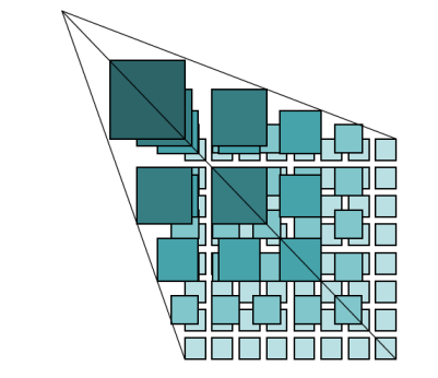
Figure 1 tile matrix set
In figure 2, each tile matrix has
- its tile size as a scale;
- its width(TileWidth) and its height(TileHeight) defined by the number of pixels, that is, its tile size. The tile size SuperMap iServer now provides is 256*256;
- the upper left corner coordinate of bounding box(TileMatrixminX, TileMatrixmaxY);
- the width and the height of a matrix(MatrixWidth, MatrixHeight) defined by a tile as a unit, such as the number of tiles.
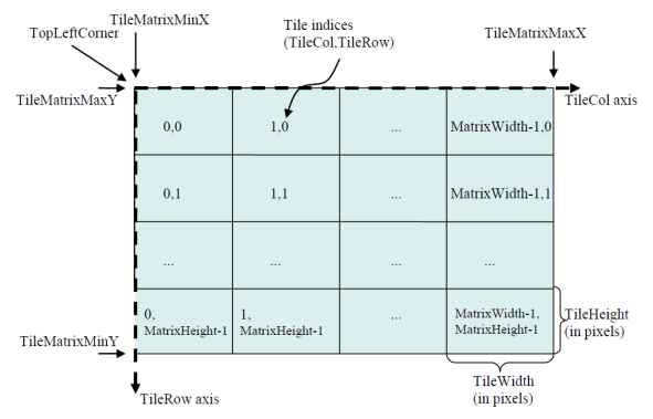
Figure 2 Tile matrix
Each tile in the tile matrix is identified by the row number and the column number of each tile(TileRow, TileCol), the row number and the column number being counted from the upper left tile in tile matrix, (0, 0) as the beginning row number and the beginning column number, successively to the right increase and down increase, as shown in Figure 2.
Scale
The server of WMTS only provides the service of limited number of coordinates and scales, in order to improve the interoperability between the client and the server, WMTS proposing a concept of well-known scale set. The well-known scale set is an agreement among the servers, composed of a public coordinate reference system and a group of public well-known scale sets. The definition of well-known scale set is only an agreement mechanism, not necessary in respect of the interoperability in the technology.
Please refer to Coordinate reference system supported by iServer OGC services for more information.
SuperMap iServer WMTS server provides tile data that based on scale collection and refer to wellKnownScaleSets. Please refer to WellknownScale for more contents about universal scale collection.
Scale=1:Ground resolution (a)*Screen resolution (pixel/inch)/0.0254 (m/inch)
This method can be simplified for: Scale=0.0254/(a*dpi).
The ground resolution (a) is to the actual distance of a pixel,the unit is meter. The screen resolution (dpi) is to the number of pixels every inch screen of the length contains and general default is 96 dpi, namely, each inch has 96 pixels. 0.0254 (m/inch) means the unit conversion between the meter and inch.
For the WMTS 1.0.0 standard service, the resolution is defined by the pixel size (0.28mm=0.00028m). It converts into screen resolution, namely, the pixel number in every inch is: 1inch/(0.00028m/0.0254(m/inch))=0.0254/0.00028≈90.714.
The default screen resolution to output maps of SuperMap iServer is 96, which is defined by electronic map data specification. It is different with that in WMTS 1.0.0. When using local caches (such as MBTiles) to publish WMTS services, it may be different. So SuperMap iServer provides wmts-china interface instance. This interface adopts the map scale defined in electronic map data specification and a common screen resolution 96.
TopLeftCorner
In WMTS, TopLeftCorner is the character sequence that describes the upper-left coordinates of TileMatrixSet; which is made up of X and Y. In the geographic coordinate system, that the longitude is before the latitude does not conform to the international practice. Although there is no standard to stipulate thst the latitude should be in front of longitude, in general, latitude is in front of longitude.
In the WMTS services provided by SuperMap iServer, the TopLeftCorner of geographic coordinate system is "Y X"; The TopLeftCorner of projected coordinate system, custom coordinate and plane-coordinate system is "X Y".
Table 1 TopLeftCorner order of common coordinate system
| Coordinate System | 4326 | 3857 | 4490
(National geodetic coordinate system) |
EPSG:0 (Custom coordinate system) |
Plane-coordinate System |
| TopLeftCorner Coordinate Order | YX | XY | YX | XY | XY |
See
Please refer to: WMTS relevant specifications of OGC(Open Geospatial Consortium), http://www.opengeospatial.org.
参考:https://heilongjiang.tianditu.gov.cn/iportal/help/html/en/API/WMTS/wmts_introduce.htm


【推荐】国内首个AI IDE,深度理解中文开发场景,立即下载体验Trae
【推荐】编程新体验,更懂你的AI,立即体验豆包MarsCode编程助手
【推荐】抖音旗下AI助手豆包,你的智能百科全书,全免费不限次数
【推荐】轻量又高性能的 SSH 工具 IShell:AI 加持,快人一步
· 分享4款.NET开源、免费、实用的商城系统
· 全程不用写代码,我用AI程序员写了一个飞机大战
· MongoDB 8.0这个新功能碉堡了,比商业数据库还牛
· 白话解读 Dapr 1.15:你的「微服务管家」又秀新绝活了
· 上周热点回顾(2.24-3.2)
2018-02-21 Kernel的意义
2016-02-21 Android真机调试试验