使用openLayer在地图上添加标注
因为在实际的项目中要用到这个功能,找了好久才得以实现,代码来自:https://www.jianshu.com/p/4af2a52a0fc6
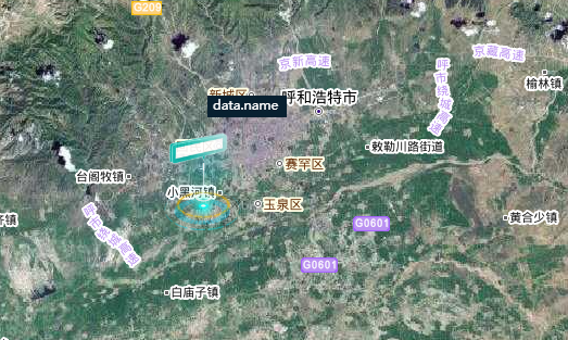
效果如下;
需要引入的类
//添加标注所用到的类
import Vectors from 'ol/layer/Vector.js'
import { WMTS, Vector } from 'ol/source.js'
import Feature from 'ol/Feature'
import OlGeomPoint from 'ol/geom/Point'
import OlStyleStyle from 'ol/style/Style'
import OlStyleIcon from 'ol/style/Icon'
import Text from 'ol/style/Text'
import Fill from 'ol/style/Fill'
添加标注所用到的函数
      /*创建矢量标注
 *@param{object}  data  标注的数据
*/
createLabel() {
    // 初始化标签要素
    let feature = new Feature({
        geometry: new OlGeomPoint(fromLonLat([111.65, 40.82])),             // 标签位置
        name: "data.name",                                  // 标注显示的文字
        img: require('./../assets/index/selected.png'),      // 标注显示的logo图片
    })
    feature.setId(1)             // 设置ID
    feature.setStyle(this.createLabelStyle(feature))          // 设置标注样式
    let source = new Vector({})            // 初始化矢量数据源
    source.addFeature(feature)          // 将标签要素添加至矢量数据源
    let layer = new Vectors({               // 创建矢量图层
        source: source
    })
    this.map.addLayer(layer)              // 将矢量图层添加至地图
},

/*创建标注样式
 *@param{object}  feature  标注要素
 *@return {object} 返回创建的标注样式对象
*/
createLabelStyle(feature) {
    //返回一个样式
    return new OlStyleStyle({
        //图标样式
        image: new OlStyleIcon({
            anchor: [10, 18],      //设置图标偏移
            scale: 0.6,      // 图标缩小显示
            anchorOrigin: 'top-right',     //标注样式的起点位置
            anchorXUnits: 'pixels',    //X方向单位:分数
            anchorYUnits: 'pixels',     //Y方向单位:像素
            offsetOrigin: 'bottom-left',   //偏移起点位置的方向
            opacity: 0.9,    //透明度
            src: feature.get('img')     //图片路径
        }),
        //文本样式
        text: new Text({
        textAlign: 'center',     //对齐方式
        textBaseline: 'middle',    //文本基线
        font: 'normal 12px 微软雅黑',     //字体样式
        text: feature.get('name'),    //文本内容
        offsetY: -25,    // Y轴偏置
        fill: new Fill({        //填充样式
        color: '#ffffff'
        }),
        backgroundFill: new Fill({      // 填充背景
        color:"#082030",
        }),
        padding: [2, 5, 2, 5],
    }),
       // 设置层级
    zIndex: 199
});
}
我的完整代码:地图引用的是天地图中的卫星图遗迹对应的标注图层,在使用时需要输入一个你自己申请的提啊你图密钥
<template>
  <div id="map" class="map"></div>
</template>
<script>
//引用地图过程中用到的类
import MapInit from '../components/tianditu/Mapinit.js';
import Map from 'ol/Map'
import View from 'ol/View'
import TileLayer from 'ol/layer/Tile'
import OSM from 'ol/source/OSM'
import XYZ from 'ol/source/XYZ'
import {fromLonLat} from 'ol/proj.js';
import GroupLayer from "ol/layer/Group";

//添加标注所用到的类
import Vectors from 'ol/layer/Vector.js'
import { WMTS, Vector } from 'ol/source.js'
import Feature from 'ol/Feature'
import OlGeomPoint from 'ol/geom/Point'
import OlStyleStyle from 'ol/style/Style'
import OlStyleIcon from 'ol/style/Icon'
import Text from 'ol/style/Text'
import Fill from 'ol/style/Fill'


export default {
  data() {
    return {
        map: null,
        baseLayer1:null,
        view: null,
        map_ter:null,
    };
  },
  methods: {
      initMap(){

          //天地图卫星底图
        var sourceSatellite = new XYZ({
          url: 'http://t3.tianditu.com/DataServer?T=img_w&tk=你的密钥&x={x}&y={y}&l={z}'
        });
        var tileSatellite = new TileLayer({
          id: "tileSatellite",
          title: "天地图卫星底图",
          layerName: "baseMap",
          source: sourceSatellite
        });
        //天地图卫星底图标注图层
        var sourceSatelliteMark = new XYZ({
          url: "http://t4.tianditu.com/DataServer?T=cva_w&tk=你的密钥&x={x}&y={y}&l={z}"
        })
        var satelliteMark = new TileLayer({
          id: "satelliteMark",
          title: "天地图卫星底图标注图层",
          layerName: "baseMap",
          source: sourceSatelliteMark
        });
        this.baseLayer1 = new GroupLayer({
          layers: [tileSatellite, satelliteMark],
          visible: true
        })

        this.view = new View({
          //初始位置(呼市)
          // center: transform([111.65, 40.82], "EPSG:4326", "EPSG:3857"),
          center: fromLonLat([111.65, 40.82]),
          projection: 'EPSG:3857',
          zoom: 10                                            //加载地图的层级
        })
        this.map = new Map({
          target: 'map',
          view: this.view,
          layers: [this.baseLayer1]
        });


        //调用方法创建标签
       this.createLabel();


      },

      /*创建矢量标注
 *@param{object}  data  标注的数据
*/
createLabel() {
    // 初始化标签要素
    let feature = new Feature({
        geometry: new OlGeomPoint(fromLonLat([111.65, 40.82])),             // 标签位置
        name: "data.name",                                  // 标注显示的文字
        img: require('./../assets/index/selected.png'),      // 标注显示的logo图片
    })
    feature.setId(1)             // 设置ID
    feature.setStyle(this.createLabelStyle(feature))          // 设置标注样式
    let source = new Vector({})            // 初始化矢量数据源
    source.addFeature(feature)          // 将标签要素添加至矢量数据源
    let layer = new Vectors({               // 创建矢量图层
        source: source
    })
    this.map.addLayer(layer)              // 将矢量图层添加至地图
},

/*创建标注样式
 *@param{object}  feature  标注要素
 *@return {object} 返回创建的标注样式对象
*/
createLabelStyle(feature) {
    //返回一个样式
    return new OlStyleStyle({
        //图标样式
        image: new OlStyleIcon({
            anchor: [10, 18],      //设置图标偏移
            scale: 0.6,      // 图标缩小显示
            anchorOrigin: 'top-right',     //标注样式的起点位置
            anchorXUnits: 'pixels',    //X方向单位:分数
            anchorYUnits: 'pixels',     //Y方向单位:像素
            offsetOrigin: 'bottom-left',   //偏移起点位置的方向
            opacity: 0.9,    //透明度
            src: feature.get('img')     //图片路径
        }),
        //文本样式
        text: new Text({
        textAlign: 'center',     //对齐方式
        textBaseline: 'middle',    //文本基线
        font: 'normal 12px 微软雅黑',     //字体样式
        text: feature.get('name'),    //文本内容
        offsetY: -25,    // Y轴偏置
        fill: new Fill({        //填充样式
        color: '#ffffff'
        }),
        backgroundFill: new Fill({      // 填充背景
        color:"#082030",
        }),
        padding: [2, 5, 2, 5],
    }),
       // 设置层级
    zIndex: 199
});
}

  },
  mounted() {
      this.initMap();
  },
};
</script>

<style scoped>
#map {
  width: 100%;
  height: 800px;
}
</style>