我在写自己的WorldWind插件时,遇到很大挫折,上周六本来想写个简单的画线的插件,费了九牛二虎之力终于画出了,如何以动画效果画出线的问题没解决。Direct3D中画线本来是个简单的事,画到球面上也不难,但是实践告诉我:我前期学习WW,又犯了眼高手低的毛病!改动人家写好的插件代码容易,但要把插件的整个流程都自己写,就没想象的简单啦,写代码不严谨的小问题就不说了,我周六画线的主要问题是Direct3D编程都浮在表面,连PrimitiveType中各类型的基元数和顶点的关系没搞清楚。(如想了解请参看:http://www.cnblogs.com/wuhenke/archive/2009/12/27/1633411.html红色部分)
自己在画线上体验,让我决定先学习Measure插件。另外,我一直想做个类似VE插件,支持加载ArcGIS切图方式的影像,自己想了很久,有几个主要困惑没解决:投影方式不同如何处理、只要部分影像(如何计算行列数)、切图的中心问题(VE影像是全球的,切图中心经纬度为(0°,0°))等等。所以,前段WW实践,让我很受打击,博客就没心情更新啦!虽然理论和实践还有很大的距离,但是总结还是很重要的!
上面都是题外话了,开始说说Measure插件吧!总体感觉Measure插件很强大,如果能搞清楚,在球面上画点、线、面都不是难事啦。(前提:要有点DirectX编程基础)
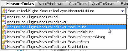
MeasureTool.cs中有两个大类:MeasureTool(插件类)和MeasureToolLayer(渲染对象类)。MeasureToolLayer类中又包含五个内部类:MeasureLine、MeasureMultiLine 、MeasurePropertiesDialog、 MeasureState 、SaveMultiLine(如下图)

MeasureTool作为插件类,需要实现Load() 和Unload()方法,不详说。Load()中注册了一些事件。
 加载代码
加载代码
{
layer = new MeasureToolLayer(
this,
ParentApplication.WorldWindow.DrawArgs );
//设置纹理路径
layer.TexturePath = Path.Combine(PluginDirectory,"Plugins\\Measure");
ParentApplication.WorldWindow.CurrentWorld.RenderableObjects.Add(layer);
menuItem = new MenuItem("Measure\tM");
menuItem.Click += new EventHandler(menuItemClicked);
ParentApplication.ToolsMenu.MenuItems.Add( menuItem );
// Subscribe events 注册了事件
ParentApplication.WorldWindow.MouseMove += new MouseEventHandler(layer.MouseMove);
ParentApplication.WorldWindow.MouseDown += new MouseEventHandler(layer.MouseDown);
ParentApplication.WorldWindow.MouseUp += new MouseEventHandler(layer.MouseUp);
ParentApplication.WorldWindow.KeyUp +=new KeyEventHandler(layer.KeyUp);
}
MeasureToolLayer作为渲染对象类,是WW插件实现的重点。必须重载的方法Initialize()、Update()、Render()和PerformSelectionAction(DrawArgs drawArgs)。
我们先分别看看MeasureToolLayer的五个内部类。
public enum MeasureState
{
Idle,
Measuring,
Complete
}
MeasureState是个枚举类型,存放Measure的当前状态的(空闲、测量中、完成)。

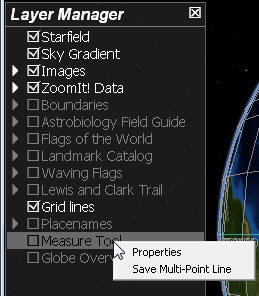
从上图中,我们可看到MeasurePropertiesDialog和 SaveMultiLine类。
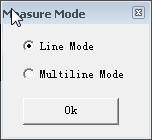
 MeasurePropertiesDialog继承自Form,主要是设置画线的类型:单线、多条线。
 设置MeasureMode代码
{
if (lineModeButton.Checked == true)
World.Settings.MeasureMode = MeasureMode.Single;
else
World.Settings.MeasureMode = MeasureMode.Multi;
this.Close();
}
SaveMultiLine类基础自Form。主要实现将画出的多线,保存为KML或Shp格式。
 保存代码
保存代码
{
// Heh.
SaveFileDialog chooser = new SaveFileDialog();
chooser.DefaultExt = "*.csv";
chooser.Filter = "kml files (*.kml)|*.kml|Shape files (*.shp)|*.shp";
chooser.Title = "Save Multiline";
chooser.ShowDialog(MainApplication.ActiveForm);
String filename = chooser.FileName;
Console.WriteLine(filename);
try
{
if(filename.EndsWith(".kml"))
{
StreamWriter writer = new StreamWriter(filename);
string kml = writeKML();
writer.WriteLine(kml);
writer.Close();
}
//need to be able to save to a network a shapefile accessible
if(filename.EndsWith(".shp"))
{
writeShape(filename);
}
}
catch(Exception ex)
{
MessageBox.Show(ex.Message);
}
}
输出KML文件代码;
 KML代码
KML代码
{
//construct XML to send
XmlDocument doc = new XmlDocument();
XmlNode kmlnode = doc.CreateElement("kml");
XmlNode node = doc.CreateElement("Placemark");
XmlNode name = doc.CreateElement("name");
name.InnerText = "New Measurement";
node.AppendChild(name);
XmlNode desc = doc.CreateElement("description");
string description = "New Measurement";
desc.InnerXml = description;
node.AppendChild(desc);
XmlNode polygon = doc.CreateElement("Polygon");
string request = "<outerBoundaryIs><LinearRing><coordinates>";
foreach(MeasureLine line in m_multiline)
{
Double lat = line.StartLatitude.Degrees;
Double lon = line.StartLongitude.Degrees;
request += lon+","+lat+",100\n";
}
request += "</coordinates></LinearRing></outerBoundaryIs>";
polygon.InnerXml= request;
node.AppendChild(polygon);
kmlnode.AppendChild(node);
doc.AppendChild(kmlnode);
return doc.OuterXml;
}
保存为SHP格式文件代码
 保存为Shap代码
{
IntPtr shphandle = ShapeLib.SHPCreate(filename,ShapeLib.ShapeType.PolyLine);
double[] lat = new double[m_multiline.Count];
double[] lon = new double[m_multiline.Count];
int i=0;
foreach(MeasureLine line in m_multiline)
{
lat[i] = line.StartLatitude.Degrees;
lon[i] = line.StartLongitude.Degrees;
i++;
}
ShapeLib.SHPObject poly = ShapeLib.SHPCreateSimpleObject(ShapeLib.ShapeType.Polygon,m_multiline.Count,lon,lat,null);
ShapeLib.SHPWriteObject(shphandle,0,poly);
ShapeLib.SHPDestroyObject(poly);
ShapeLib.SHPClose(shphandle);
}
上面是右键菜单的两个功能,如果实现添加右键菜单呢??很简单,MeasureToolLayer类只要重载RenderObject类的BuildContextMenu(ContextMenu menu)方法。示例代码如下:
 添加右键菜单代码
/// Fills the context menu with menu items specific to the layer.
/// </summary>
public override void BuildContextMenu(ContextMenu menu)
{
menu.MenuItems.Add("Properties", new System.EventHandler(OnPropertiesClick));
menu.MenuItems.Add("Save Multi-Point Line", new System.EventHandler(saveLine));
}
OnPropertiesClick和saveLine就是用来调用两个窗体类的。
MeasureMultiLine继承自ArrayList,主要是存放MeasureLine的集合。
{
//添加线
public void addLine(MeasureLine line)
{
Add(line);
}
//删除最后一条线
public void deleteLine()
{
RemoveAt(Count-1);
}
//计算集合中线的总长度,我们关注如何计算单条线的长度。
public double getLength()
{
double sum = 0.0;
foreach(MeasureLine line in this)
sum += line.Linear;
return sum;
}
public void Render(DrawArgs drawArgs)
{
foreach(MeasureLine line in this)
{
try
{
line.Render(drawArgs);
}
catch
{}
}
}
}
MeasureLine继承自ListViewItem,是该Measure插件的关键部分,主要是对线对象的计算和部分渲染。这里面知识点比较重要,很多可以被我们借鉴重用。其中用到的重要方法Calculate() 和Render(),还有一些没用到的方法(这里暂不分析)。
{
Angle angularDistance = World.ApproxAngularDistance( startLatitude, startLongitude, endLatitude, endLongitude );
Linear = angularDistance.Radians * world.EquatorialRadius;
//每两度一个点(下面计算不是好理解,但是我们可以借鉴的重点)
int samples = (int)(angularDistance.Radians*30); // 1 point for every 2 degrees.
if(samples<2)
samples = 2;
//构建点集合(线中取samples个点)
LinearTrackLine = new CustomVertex.PositionColored[samples];
for(int i=0;i<LinearTrackLine.Length;i++)
LinearTrackLine[i].Color = World.Settings.MeasureLineLinearColorXml;;
Angle lat,lon=Angle.Zero;
for(int i=0; i<samples; i++)
{
float t = (float)i / (samples-1);
World.IntermediateGCPoint(t, startLatitude, startLongitude, endLatitude, endLongitude, angularDistance, out lat, out lon );
double elevation = 0;
if(useTerrain)
elevation = world.TerrainAccessor.GetElevationAt(lat.Degrees,lon.Degrees,1024);
//将球面坐标,转为笛卡尔三维坐标(左手坐标系)
Vector3 subSegmentXyz = MathEngine.SphericalToCartesian(lat, lon,
world.EquatorialRadius + elevation * World.Settings.VerticalExaggeration );
LinearTrackLine[i].X = subSegmentXyz.X;
LinearTrackLine[i].Y = subSegmentXyz.Y;
LinearTrackLine[i].Z = subSegmentXyz.Z;
}
//计算两点连线的中点坐标(重点)
WorldXyzMid = world.IntermediateGCPoint(0.5f, startLatitude, startLongitude, endLatitude, endLongitude, angularDistance );
}
Render()方法:
{
// Draw the measure line + ends
Vector3 referenceCenter = new Vector3(
(float)drawArgs.WorldCamera.ReferenceCenter.X,
(float)drawArgs.WorldCamera.ReferenceCenter.Y,
(float)drawArgs.WorldCamera.ReferenceCenter.Z);
//将球体放在啥位置上!(我的理解)
drawArgs.device.Transform.World = Matrix.Translation(
-referenceCenter
);
if(World.Settings.MeasureShowGroundTrack && IsGroundTrackValid)
drawArgs.device.DrawUserPrimitives(PrimitiveType.LineStrip, GroundTrackLine.Length-1, GroundTrackLine);
drawArgs.device.DrawUserPrimitives(PrimitiveType.LineStrip, LinearTrackLine.Length-1, LinearTrackLine);
drawArgs.device.Transform.World = drawArgs.WorldCamera.WorldMatrix;
//判断一个点是否可见(方法重要)
if(!drawArgs.WorldCamera.ViewFrustum.ContainsPoint(WorldXyzMid))
// Label is invisible
return;
Vector3 labelXy = drawArgs.WorldCamera.Project(WorldXyzMid - referenceCenter);
string label ="";//= Text;
if( groundTrack>0)
label += FormatDistance(groundTrack) + Units;
else
label += FormatDistance(linearDistance) + Units;
drawArgs.defaultDrawingFont.DrawText(null, label, (int)labelXy.X, (int)labelXy.Y, World.Settings.MeasureLineLinearColor );
}
上面代码画出的线和长度,在任何缩放级别下都是可见的,不是太好。下面是我借鉴VE插件代码,实现了缩放级别控制,在一定级别下才显示线的长度。
public int GetZoomLevelByTrueViewRange(double trueViewRange)
{
int maxLevel = 3; //视角范围为45度
int minLevel = 19;
int numLevels = minLevel - maxLevel + 1;
int retLevel = maxLevel;
for (int i = 0; i < numLevels; i++)
{
retLevel = i + maxLevel;
double viewAngle = 180;
for (int j = 0; j < i; j++)
{
viewAngle = viewAngle / 2.0;
}
if (trueViewRange >= viewAngle)
{
break;
}
}
return retLevel;
}
然后,在上面的Render()里添加控制条件 if (GetZoomLevelByTrueViewRange(drawArgs.WorldCamera.TrueViewRange.Degrees) > 4) ,来控制长度的显示。
 添加层次控制
{
// Draw the measure line + ends
Vector3 referenceCenter = new Vector3(
(float)drawArgs.WorldCamera.ReferenceCenter.X,
(float)drawArgs.WorldCamera.ReferenceCenter.Y,
(float)drawArgs.WorldCamera.ReferenceCenter.Z);
drawArgs.device.Transform.World = Matrix.Translation(
-referenceCenter
);
if(World.Settings.MeasureShowGroundTrack && IsGroundTrackValid)
drawArgs.device.DrawUserPrimitives(PrimitiveType.LineStrip, GroundTrackLine.Length-1, GroundTrackLine);
drawArgs.device.DrawUserPrimitives(PrimitiveType.LineStrip, LinearTrackLine.Length-1, LinearTrackLine);
drawArgs.device.Transform.World = drawArgs.WorldCamera.WorldMatrix;
if (GetZoomLevelByTrueViewRange(drawArgs.WorldCamera.TrueViewRange.Degrees) > 4)
{
if(!drawArgs.WorldCamera.ViewFrustum.ContainsPoint(WorldXyzMid))
// Label is invisible
return;
Vector3 labelXy = drawArgs.WorldCamera.Project(WorldXyzMid - referenceCenter);
string label ="";//= Text;
if( groundTrack>0)
label += FormatDistance(groundTrack) + Units;
else
label += FormatDistance(linearDistance) + Units;
drawArgs.defaultDrawingFont.DrawText(null, label, (int)labelXy.X, (int)labelXy.Y, World.Settings.MeasureLineLinearColor );
}
}
下面我们看一下MeasureToolLayer类。
 代码
代码
{
if(!isOn)
return;
// Turn off light
if (World.Settings.EnableSunShading) drawArgs.device.RenderState.Lighting = false;
// Check that textures are initialised
if(!isInitialized)
Initialize(drawArgs);
if(DrawArgs.MouseCursor == CursorType.Arrow)
// Use our cursor when the mouse isn't over other elements requiring different cursor
//使用自己的鼠标类型(可以借鉴学习)
if(State == MeasureState.Idle)
return;
//稍后分析
if (!CalculateRectPlacement(drawArgs))
return;
if(Distance < 0.01)
return;
Device device = drawArgs.device;
device.RenderState.ZBufferEnable = false;
device.TextureState[0].ColorOperation = TextureOperation.Disable;
device.VertexFormat = CustomVertex.PositionColored.Format;
// Draw the measure line + ends
/*
device.DrawUserPrimitives(PrimitiveType.LineStrip, measureLine.Length-1, measureLine);
device.DrawUserPrimitives(PrimitiveType.LineStrip, startPoint.Length-1, startPoint);
device.DrawUserPrimitives(PrimitiveType.LineList, endPoint.Length>>1, endPoint);
*/
//绘制线集合
multiline.Render(drawArgs);
// Draw the info rect
device.TextureState[0].ColorOperation = TextureOperation.SelectArg1;
device.SetTexture(0,m_texture);
device.VertexFormat = CustomVertex.TransformedColoredTextured.Format;
device.DrawUserPrimitives(PrimitiveType.TriangleStrip, 2, rect);
device.TextureState[0].ColorOperation = TextureOperation.Disable;
//绘制连接线(三个点)
device.DrawUserPrimitives(PrimitiveType.LineStrip, 2, rectLineConnection);
device.DrawUserPrimitives(PrimitiveType.LineStrip, rectFrame.Length-1, rectFrame);
drawArgs.defaultDrawingFont.DrawText(null, labelText, labelTextRect, DrawTextFormat.None, 0xff << 24);
device.RenderState.ZBufferEnable = true;
if (World.Settings.EnableSunShading) drawArgs.device.RenderState.Lighting = true;
}
光标问题
DrawArgs.cs中CursorType中所有光标类型。
/// <summary>
/// Mouse cursor
/// </summary>
public enum CursorType
{
Arrow = 0,
Hand,
Cross,
Measure,
SizeWE,
SizeNS,
SizeNESW,
SizeNWSE
}
更新光标方法340行
 更新光标代码
{
if(lastCursor == mouseCursor)
return;
switch( mouseCursor )
{
case CursorType.Hand:
parent.Cursor = System.Windows.Forms.Cursors.Hand;
break;
case CursorType.Cross:
parent.Cursor = System.Windows.Forms.Cursors.Cross;
break;
case CursorType.Measure:
if(measureCursor == null)
measureCursor = ImageHelper.LoadCursor("measure.cur");
parent.Cursor = measureCursor;
break;
case CursorType.SizeWE:
parent.Cursor = System.Windows.Forms.Cursors.SizeWE;
break;
case CursorType.SizeNS:
parent.Cursor = System.Windows.Forms.Cursors.SizeNS;
break;
case CursorType.SizeNESW:
parent.Cursor = System.Windows.Forms.Cursors.SizeNESW;
break;
case CursorType.SizeNWSE:
parent.Cursor = System.Windows.Forms.Cursors.SizeNWSE;
break;
default:
parent.Cursor = System.Windows.Forms.Cursors.Arrow;
break;
}
lastCursor = mouseCursor;
}
在重点处绘制矩形,原来是绘制圆圈的,其实可以在球上任意点绘制多边形的。

关键代码为:
 代码
代码
{
if(!drawArgs.WorldCamera.ViewFrustum.ContainsPoint(position))
return;
// Draw the circle - TODO: if the circle doesn't have to always face the user it can be pre-calculated
Vector3 referenceCenter = new Vector3(
(float)drawArgs.WorldCamera.ReferenceCenter.X,
(float)drawArgs.WorldCamera.ReferenceCenter.Y,
(float)drawArgs.WorldCamera.ReferenceCenter.Z);
Vector3 startXy = drawArgs.WorldCamera.Project(position - referenceCenter);
float circleRadius = 8;
for(int i=0;i<circle.Length;i++)
{
float angle = (float)(i*2*Math.PI/(circle.Length-1));
circle[i].X = (float)(startXy.X +Math.Sin(angle)*circleRadius );
circle[i].Y = (float)(startXy.Y +Math.Cos(angle)*circleRadius) ;
circle[i].Color = World.Settings.MeasureLineLinearColorXml;;
}
drawArgs.device.VertexFormat = CustomVertex.TransformedColored.Format;
drawArgs.device.Transform.World = Matrix.Translation(
-referenceCenter
);
//这里我有个疑惑:为啥要是TransformedColored而不是PositionColored?为什么PrimitiveType必须为线形(如:LineStrip)而不能是TrangileList??TrangileList是不会出现结果的!
drawArgs.device.DrawUserPrimitives(PrimitiveType.LineStrip, circle.Length-1, circle);
// drawArgs.device.DrawUserPrimitives(PrimitiveType.TriangleList, 1, circle);
drawArgs.device.Transform.World = drawArgs.WorldCamera.WorldMatrix;
drawArgs.device.VertexFormat = CustomVertex.PositionColored.Format;
}
我们最后来看一下CalculateRectPlacement()方法
{
int labelLinePoint = FindAnchorPoint();
if(labelLinePoint < 0)
{
// Measure line is not visible
return false;
}
Vector3 referenceCenter = new Vector3(
(float)drawArgs.WorldCamera.ReferenceCenter.X,
(float)drawArgs.WorldCamera.ReferenceCenter.Y,
(float)drawArgs.WorldCamera.ReferenceCenter.Z
);
Angle displayAngle = CalcAngle(labelLinePoint, referenceCenter);
if( Angle.IsNaN(displayAngle) )
return false;
const int leg1Len = 30;
const int leg2Len = 5;
Vector3 screenAnchor = m_drawArgs.WorldCamera.Project(
new Vector3(
measureLine[labelLinePoint].X,
measureLine[labelLinePoint].Y,
measureLine[labelLinePoint].Z ) - referenceCenter);
float x1 = (float)(screenAnchor.X + Math.Cos(displayAngle.Radians)*leg1Len);
float y1 = (float)(screenAnchor.Y + Math.Sin(displayAngle.Radians)*leg1Len);
float x2 = x1;
float y2 = y1;
// Find direction of 2nd leg.
int quadrant = (int)((displayAngle.Radians)/(Math.PI/2));
switch (quadrant % 4)
{
case 0:
case 3:
x2 += leg2Len;
break;
case 1:
case 2:
x2 -= leg2Len;
break;
}
// Calculate label box position / size
if (World.Settings.MeasureMode == MeasureMode.Multi)
{
Distance = multiline.getLength();
//labelText = Distance>=10000 ?
// string.Format( "Total Distance: {0:f1}km", Distance/1000 ) :
// string.Format( "Total Distance: {0:f1}m", Distance );
labelText = "Total Distance: " + ConvertUnits.GetDisplayString(Distance);
}
else
{
//labelText = Distance>=10000 ?
// string.Format( "Distance: {0:f1}km", Distance/1000 ) :
// string.Format( "Distance: {0:f1}m", Distance );
labelText = "Distance: " + ConvertUnits.GetDisplayString(Distance);
}
labelText += string.Format("\nBearing: {0:f1}", Azimuth.Degrees );
//获取绘制文本的外矩形
labelTextRect = m_drawArgs.defaultDrawingFont.MeasureString(null, labelText, DrawTextFormat.None, 0);
Rectangle tsize = labelTextRect;
const int xPad = 4;
const int yPad = 1;
tsize.Inflate( xPad, yPad );
labelTextRect.Offset(-tsize.Left, -tsize.Top);
tsize.Offset(-tsize.Left, -tsize.Top);
rectLineConnection[0].X = screenAnchor.X;
rectLineConnection[0].Y = screenAnchor.Y;
rectLineConnection[1].X = x1;
rectLineConnection[1].Y = y1;
rectLineConnection[2].X = x2;
rectLineConnection[2].Y = y2;
if(x2>x1)
{
labelTextRect.Offset((int)x2, 0);
tsize.Offset((int)x2, 0);
}
else
{
int xof = (int)(x2-tsize.Width);
labelTextRect.Offset(xof, 0);
tsize.Offset(xof, 0);
}
tsize.Offset(0, (int)(y2 - tsize.Height/2));
labelTextRect.Offset(0, (int)(y2 - tsize.Height/2));
rect[0].X = tsize.Left;
rect[0].Y = tsize.Top;
rect[1].X = rect[0].X;
rect[1].Y = tsize.Bottom;
rect[2].X = tsize.Right;
rect[2].Y = rect[0].Y;
rect[3].X = rect[2].X;
rect[3].Y = rect[1].Y;
rect[4].X = rect[0].X;
rect[4].Y = rect[1].Y;
rectFrame[0].X = tsize.Left;
rectFrame[0].Y = tsize.Top;
rectFrame[1].X = rectFrame[0].X;
rectFrame[1].Y = tsize.Bottom;
rectFrame[2].X = tsize.Right;
rectFrame[2].Y = rectFrame[1].Y;
rectFrame[3].X = rectFrame[2].X;
rectFrame[3].Y = rectFrame[0].Y;
rectFrame[4].X = rectFrame[0].X;
rectFrame[4].Y = rectFrame[0].Y;
// Cap at start of measure
Vector3 a = new Vector3(measureLine[0].X, measureLine[0].Y, measureLine[0].Z );
Vector3 b = new Vector3(measureLine[1].X, measureLine[1].Y, measureLine[1].Z );
Vector3 vCap = Vector3.Cross(a,b);
vCap.Normalize();
const int lineCapSize = 6;
vCap.Scale( (float)m_drawArgs.WorldCamera.Distance/750f*lineCapSize );
Vector3 worldXyzStart = new Vector3( measureLine[0].X, measureLine[0].Y, measureLine[0].Z );
Vector3 va = Vector3.Add( worldXyzStart, vCap );
Vector3 vb = Vector3.Add( worldXyzStart, -vCap );
startPoint[0].X = va.X;
startPoint[0].Y = va.Y;
startPoint[0].Z = va.Z;
startPoint[1].X = vb.X;
startPoint[1].Y = vb.Y;
startPoint[1].Z = vb.Z;
// Cap at end of measure
int last = measureLine.Length-1;
Vector3 worldXyzEnd = new Vector3(
measureLine[last].X,
measureLine[last].Y,
measureLine[last].Z );
int beforeLast = last-1;
vCap = new Vector3(
measureLine[beforeLast].X,
measureLine[beforeLast].Y,
measureLine[beforeLast].Z );
vCap.Subtract(worldXyzEnd);
vCap.Normalize();
vCap.Scale( (float)(m_drawArgs.WorldCamera.Distance/750f*lineCapSize) );
vb = va = Vector3.Add( worldXyzEnd , vCap );
const float arrowHeadAngle = 0.25f*(float)Math.PI;
va.TransformCoordinate( Matrix.RotationAxis( worldXyzEnd, (float)Math.PI+arrowHeadAngle ));
vb.TransformCoordinate( Matrix.RotationAxis( worldXyzEnd, arrowHeadAngle));
endPoint[0].X = va.X;
endPoint[0].Y = va.Y;
endPoint[0].Z = va.Z;
endPoint[1].X = vb.X;
endPoint[1].Y = vb.Y;
endPoint[1].Z = vb.Z;
Matrix rotate90 = Matrix.RotationAxis( worldXyzEnd, (float)Math.PI*0.5f );
va.TransformCoordinate( rotate90 );
vb.TransformCoordinate( rotate90 );
endPoint[2].X = va.X;
endPoint[2].Y = va.Y;
endPoint[2].Z = va.Z;
endPoint[3].X = vb.X;
endPoint[3].Y = vb.Y;
endPoint[3].Z = vb.Z;
return true;
}
选择可见点(该代码可被我们重用:判断球面上一点是否落在可见区域中)
{
Vector3 v = new Vector3( measureLine[linePoint].X, measureLine[linePoint].Y, measureLine[linePoint].Z );
return m_drawArgs.WorldCamera.ViewFrustum.ContainsPoint(v);
}


